 |
On-line Digital Images |
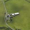
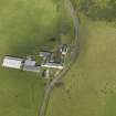
DP 066117 |
RCAHMS Aerial Photography Digital |
Oblique aerial view centred on the farmsteading, taken from the N. |
9/9/2009 |
Item Level |
|
 |
On-line Digital Images |
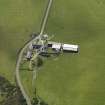
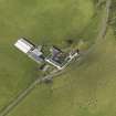
DP 066118 |
RCAHMS Aerial Photography Digital |
Oblique aerial view centred on the farmsteading, taken from the NNW. |
9/9/2009 |
Item Level |
|
 |
On-line Digital Images |
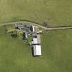
DP 066120 |
RCAHMS Aerial Photography Digital |
Oblique aerial view centred on the farmsteading, taken from the NW. |
9/9/2009 |
Item Level |
|
 |
On-line Digital Images |
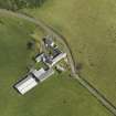
DP 066121 |
RCAHMS Aerial Photography Digital |
Oblique aerial view centred on the farmsteading, taken from the W. |
9/9/2009 |
Item Level |
|
 |
On-line Digital Images |
DP 066122 |
RCAHMS Aerial Photography Digital |
Oblique aerial view centred on the farmsteading, taken from the SW. |
9/9/2009 |
Item Level |
|
 |
On-line Digital Images |
DP 066123 |
RCAHMS Aerial Photography Digital |
Oblique aerial view centred on the farmsteading, taken from the SSE. |
9/9/2009 |
Item Level |
|
 |
On-line Digital Images |
DP 066124 |
RCAHMS Aerial Photography Digital |
Oblique aerial view centred on the farmsteading, taken from the SE. |
9/9/2009 |
Item Level |
|
 |
On-line Digital Images |
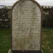
DP 081802 |
RCAHMS Field Survey Digital Photography |
View of gravestone dated 1859. |
31/3/2010 |
Item Level |
|
 |
On-line Digital Images |
SC 1202379 |
|
Lubas, extract from OS 25-inch map of 1869. |
1869 |
Item Level |
|
 |
On-line Digital Images |
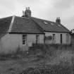
DP 081808 |
RCAHMS Field Survey Digital Photography |
Lubas farm house, taken from the NNE. |
21/7/2009 |
Item Level |
|
 |
On-line Digital Images |
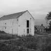
DP 081809 |
RCAHMS Field Survey Digital Photography |
Lubas barn, taken from the NE. |
21/7/2009 |
Item Level |
|
 |
On-line Digital Images |
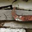
DP 081810 |
RCAHMS Field Survey Digital Photography |
Lubas, detail of sliding door hanger. |
21/7/2009 |
Item Level |
|
 |
On-line Digital Images |
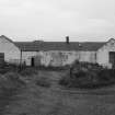
DP 081811 |
Records of the Royal Commission on the Ancient and Historical Monuments of Scotland (RCAHMS), Edinbu |
Lubas steading, taken from the S. |
21/7/2009 |
Item Level |
|
 |
On-line Digital Images |
DP 081812 |
RCAHMS Field Survey Digital Photography |
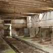
Lubas, interior of W range. |
21/7/2009 |
Item Level |
|
 |
On-line Digital Images |
DP 081813 |
RCAHMS Field Survey Digital Photography |
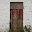
Lubas, detail of door opening in SE range. |
21/7/2009 |
Item Level |
|
|
Digital Files (Non-image) |
GV 004576 |
Records of the Royal Commission on the Ancient and Historical Monuments of Scotland (RCAHMS), Edinbu |
Map: Distribution of Pre-Improvement sites and activity. |
8/2010 |
Item Level |
|
 |
On-line Digital Images |
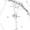
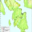
DP 097424 |
Records of the Royal Commission on the Ancient and Historical Monuments of Scotland (RCAHMS), Edinbu |
Map- Distribution of Pre-Improvement sites and activity. |
8/2010 |
Item Level |
|


