
Carnasserie Cottage


Castle (Medieval)(Possible), Dun (Prehistoric)(Possible)
Site Name Carnasserie Cottage
Classification Castle (Medieval)(Possible), Dun (Prehistoric)(Possible)
Canmore ID 22848
Site Number NM80SW 31
NGR NM 8392 0087
Datum OSGB36 - NGR
Permalink http://canmore.org.uk/site/22848


- Council Argyll And Bute
- Parish Kilmartin
- Former Region Strathclyde
- Former District Argyll And Bute
- Former County Argyll
NM80SW 31 8392 0087.
(NM 8392 0089) Enclosure (NR)
OS 1:10,000 map, (1974)
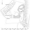
Situated on a low, rocky knoll, about 20 metres north of Carnassarie Castle are the remains of an enclosure - possibly a dun. Sub-oval on plan, it measures 18 metres N-S by 14 metres transversely within a wall 1.6 to 2.2 metres wide, best preserved on the south where inner and outer faces stand about 0.4 metres high, but do not appear to be coursed. Elsewhere, it is visible as a turf-covered scatter of stones. The entrance, about 0.6 metres wide, is in the SW. There are no internal features.
Surveyed at 1:2500 scale.
Visited by OS (R D) 12 October 1971.
Field Visit (September 1988)
...'Wall-footings and stony debris on the rocky knoll a few metres NE of the tower may represent the remains of a medieval dwelling on the site, traces of earlier walling possibly extending down the intervening ridge and being incorporated within the fabric of the NE angle of the tower itself' (p.215).
...'On the summit of a knoll 16m NNE of the castle there is an arc of walling, including a 6m-length of inner facework, around the SW edge of the summit-platform, and other traces of stony debris and short stretches of outer face along the rocky W edge. There are also slight traces of walling running down the spine of the ridge between the knoll and the NE angle of the castle, but none of the wall-foundations in this area bears visible evidence of lime mortar' (p.224).
RCAHMS 1992, visited September 1988
Excavation (May 2017 - June 2017)
NM 83900 00860 (NM80SW 31) An excavation undertaken, May – June 2017, uncovered what appear to be hearth derived occupation deposits within what is probably the remnants of a dun structure located to the N of the castle. The excavation also confirmed the presence of structures lying immediately to the W of the castle, these were perhaps initially castle
outbuildings, but remained occupied after the castle’s demise in 1685. The excavation also investigated some of the buildings belonging to the township of Carnassarie Beg, the dating evidence confirming the historical picture of a settlement occupied until the middle of the 19th century. The
excavation also showed that within the castle grounds both the castle outbuildings and those of Carnassarie Beg have been substantially affected by tree root damage. Another theme encountered during the excavation work were the topographical changes resulting from various campaigns of ‘landscaping’ within the castle grounds. which appear to
have removed any trace of buildings near the ‘garden’ gate and have significantly raised ground levels immediately to the N of the castle.
Archive: Kilmartin Museum. Report: NRHE and WoSAS SMR
Funder: Historic Environment Scotland, A’Cruach Community Fund
Roddy Regan – Kilmartin Museum
(Source: DES, Volume 18)

