
Caisteal Nan Con Duibh


Galleried Dun (Prehistoric)
Site Name Caisteal Nan Con Duibh
Classification Galleried Dun (Prehistoric)
Alternative Name(s) Mullach Dubh
Canmore ID 22744
Site Number NM80NW 22
NGR NM 8000 0762
Datum OSGB36 - NGR
Permalink http://canmore.org.uk/site/22744


- Council Argyll And Bute
- Parish Craignish
- Former Region Strathclyde
- Former District Argyll And Bute
- Former County Argyll
NM80NW 22 8000 0762.
(NM 8000 0763) Dun (NR)
OS 1:10,000 map, (1975)
'Caisteal nan Coin Duibh' (Campbell and Sandeman 1964) meaning 'Castle of the Black Dogs' is a heavily robbed dun standing on a low, narrow ridge of rock on the NW slopes of Mullach Dubh. The position is strong, with steep or precipitous drops on all sides except the SW where access is barred by a rock-bound gash some 20 yards from the entrance. The wall appears to have been from 12 to 14 feet thick, but can be measured now only on the west and NW. Elsewhere only a few footings from the outer face survive and from these it would seem that the dun originally measured about 68 feet overall north to south, and 58 feet east to west. Except where the footings extend down the slope as a kind of revetment on the SW, the outer face nowhere stands to more than three courses, and the inner face generally shows only one course. The entrance passage is in the SW. Most of its west side can be traced, including a door check, but the eastern side is ruined although its door check can still be identified. The name 'Caisteal nan Coin Duibh' traditionally comes from the Fingalian legend of a fight between Fingal's dog 'Bran' and 'For' the black dog of the Prince of Innse Orc, in which 'For' was killed, but given an honourable burial beneath a standing stone. (NM80NW 10).
A Graham 1950; M Campbell and M Sandeman 1964.
As described. Name confirmed.
Surveyed at 1:10 000 scale.
Visited by OS (R D) 27 February 1970.
Field Visit (April 1978)
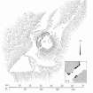
The remains of what is probably a galleried dun occupy the highest part of a rocky ridge aligned NE-SW about 1.2km NNE of Lunga House (Campbell and Sandeman 1964).
Oval on plan, the dun measures about 13m by 10m within a wall which varies from 3m to 4m in thickness. Considerable stretches of the outer face survive and on the N it rises to a height of 1.7m in ten rough courses; the inner face is less well preserved, but a long stretch is visible on the NW. There are traces of a gallery within the thickness of the wall on the NW; it was entered through a narrow passage, the S side-wall of which stands to a height of 0.4m in three courses. A second break in the line of the inner face, 2.5m to the NE, is either another entrance to the gallery or the entrance to a second chamber. Depressions in the thickness of the wall on the S may indicate the presence of yet another intramural feature. The entrance to the dun lies on the WSW; it measures about 1m in width at the outer end, 1.8m at the inner end, and is checked for a door 1m from the exterior. On the NE there is a short stretch of facing at right-angles to the line of the wall, and this may be a straight-joint similar to that at Castle Dounie (NM80NW 22) or one side of a postern gate. In the interior there are the remains of at least two-animal-pens and a modern rectilinear cairn. There is no trace of the midden-deposit noted by Campbell and Sandeman to the W of the dun, and the cairns and stretches of field-walling on the N flank of the ridge are of relatively recent date.
RCAHMS 1988, visited April 1978

