
Easdale, Slate Quarries


Slate Quarry(S) (Post Medieval)
Site Name Easdale, Slate Quarries
Classification Slate Quarry(S) (Post Medieval)
Alternative Name(s) Seil
Canmore ID 22614
Site Number NM71NW 2
NGR NM 7350 1710
NGR Description Centred NM 7350 1710
Datum OSGB36 - NGR
Permalink http://canmore.org.uk/site/22614


- Council Argyll And Bute
- Parish Kilbrandon And Kilchattan
- Former Region Strathclyde
- Former District Argyll And Bute
- Former County Argyll
NM71NW 2.00 centred 7350 1710
NM71NW 2.00 NM 73888 17099 Loading Jetty
For (associated) harbour (NM 739 171), see NM71NW 4.
Includes (former) island of Ellanbeich; listed as slate-quarries and workers' dwellings. (Full description given).
RCAHMS 1975, visited July 1971.
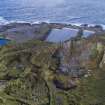
(Location cited as NM 735 173). 19th century. A series of flooded quarries with waste heaps. There are fragmentary ruins of various buildings.
J R Hume 1977.
This site has only been partially upgraded for SCRAN. For further information, please consult the Architecture Catalogues for Argyll and Bute District..
February 1998
Field Visit (July 1971)
Slate has been quarried at several sites on the islands of Nether Lorn, and remains of old workings with accompanying dwellings may be seen at Cullipool, Black Mill Bay and Toberonochy, Luing and Balvicar and Ardcaple, Seil. The most important quarries, however, were on the island of Easdale and the smaller island of Elalnbeich which, during the first half of the 19th century, became united to Seil by a causeway formed by the vast accumulation of quarry waste. (1)
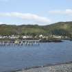
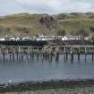
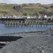
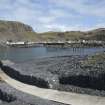
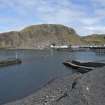
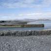
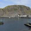
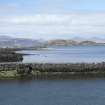
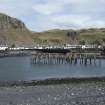
In contract with to the quarries at Ballachulish most of the good beds of slate at Easdale lay near or below ground level, and as more efficient pumps were introduced during the 19th century the workings were carried down to considerable depths. In 1869 the principal quarry at Ellanbeich (Ellenabeich) had a surface area of about 140m by 75m and a depth of some 50m. This quarry, which contained an elaborate system of railway tracks, was protected from the sea by a narrow wall of unquarried rock strengthened by a masonry wall, and when this was breached by a storm in November 1881 the entire quarry was flooded, (2) so that it now presents the appearance of a tidal basin. Most of the disused workings on Easdale Island, the oldest of which are two situated near the SE shore of the island, are also flooded. The only industrial building of importance is the ruinous engine house, probably of mid-19th century date, situated immediately east of Ellanbeich (Ellenabeich) quarry. This provided motive power for the railway system and also for the pumps in the quarry. The harbours of Ellanbeich and Easdale were built c.1826 (3) and both have jetties with vertically-set masonry. The NW quay at Easdale Island, incorporating a flight of steps, is particularly well preserved; the area to the NW is divided by rows of slate slabs, resembling headstones, into a series of compartments originally ten in all, for stacking graded loads of slates ready for shipping (around.NM7388 1709; see NRHE image AG/4851).
Most of the quarrier’s dwellings, both an Ellanbeich and on Easdale Island, are single-storeyed cottages of rubble masonry, harled and whitewashed having slate paving slabs at the street front and neatly slated roofs. The existing buildings probably date from the first quarter of the 19th century, and the internal layout corresponds closely with a survey plan of 1856. (4) Each cottage has two main rooms separated by a lobby and closet, the latter normally entered from the kitchen, the internal partitions are timber-framed with slate infilling. The main group of cottages at Ellanbeich is arranged as two back-to-back rows, each in blocks of five, four and four, separated by streets from a third row of dwelling son the WSW and a series of walled gardens of walled gardens on the ENE.
The arrangement of cottages in Easdale is less systematic than at Ellanbeich; some are grouped round three sides of a square, while other extend W and NW of the harbour. A considerable part of the island of Easdale is covered with an intricate network of dry-stone walls forming small closely-grouped enclosures. Similar enclosures formerly existed at Ellanbeich, and may be the remains of allotments used of the intensive potato-cultivation that was observed there in 1800. (5)
Quarrying operations at Easdale were at first conducted on an ad hoc basis, the necessary materials being gathered from the slate debris on the shore or quarried above water-level by the workmen engaged in particular building works. During the first half of the 18th century the quarries were greatly developed, with permanent crews of quarries preparing slates for shipment on vessels engaged in trade between the Clyde and the East Coast. (6)
When the management was taken over by the ’Marble and Slate Company of Netherlorn’ in 1745, eight crews of four men were employed, with an annual production of 500,000 slates. By 1771 the workforce had increased to thirteen crews at Easdale and five at Ellanbeich, and nineteen elsewhere on Seil and on Luing, and a production in 1795 of about 5 million slates. (7) At this period quarrying was restricted to the seams above low water level, although a system of outflow channels and sluices allowed these levels to be worked in all states of the tide.
In 1800 the quarries at Ellanbeich, which had apparently been worked down to low water level, were described as exhausted (8) but the introduction of soon after this of improved sources of power for pumping and for transport , including a windmill and steam engines, permitted work at Easdale and Ellanbeich to be carried down to great depths described above. Peak production was estimate in 1869 as about nine million slates, but this output was greatly reduced by the flooding of Ellanbeich quarry in 1881; the production at Easdale continued intermittently until c.1914. (9)
(1) The sound separating Ellanbeich from Seil is represented on a map of 1787 by G Langlands (NRS, RHP 975/1).
(2) Gillies, PH, Netherlorn, (1909), 16
(3) Bremner D, The Industries of Scotland (1869), 427
(4) ‘Ground Plan of present Quarriers Houses’ inset in unexecuted plan for the rebuilding of houses at Ellanbeich , 1856 (NRS, RHP 970/13)
(5) Leyden, Tour, 56
(6) Mackay, W The Letter Book of the Bailie John Steuart of Inverness 1715-1752, SHS (1915), Index, s.v. ‘Slate’
(7) NRS Breadalbane Collections, GD 112/18/nos. 21-4, 54-5, Marble Company Ledgers, Minute Books, Journals, passim; Stat Acct xiv (1795), 161-2
(8) Leyden, Tour, 56
(9) NSA, vii (Argyll) , 77-8; Gillies, PH, Netherlorn, (1909),10-16; Bremner D, The Industries of Scotland (1869), 425-8
RCAHMS 1975, visited July 1971
Note (September 2017)
500 Years of Slate and Spoil
When the first known references to an industrial site date from the mid-16th century, you don’t quite know what to expect upon arrival. Easdale Island, one of the Slate Islands about 15 miles south of Oban, does not disappoint as an impressive Industrial landscape.
Records show that as early as the 17th century some of the most prominent buildings of the day in Scotland – Cawdor Castle and Glasgow Cathedral amongst them - were roofed with Easdale Slate, as was Ardmaddy Castle, the nearby seat of the Campbells of Breadalbane. The Campbells, as the long-term owners of the Easdale, established quarrying across the Slate Isles and this reached its industrialised peak of 9,000,000 slates in the mid-18th century.
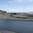
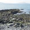
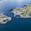
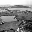
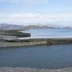
The topography and character of Easdale Island today is almost entirely the product of the slate quarrying industry, which has dominated the island for centuries. The island’s coastline has been nibbled, scarred and reshaped by surface quarrying - as have the sides of the large ridge-shaped hill in the centre. Seven enormous sunken quarry-holes, now flooded, dominate much of the island’s terrain, while the ground rises and falls in between amongst a network of spoil-heaps and flat plains made-up of discarded slate chips. Weaving amongst these are tramways that once moved the slate around the island. There are also patchworks of walled enclosures used as gardens for growing food. A village of cottages that once accommodated the workers and their families is gathered around the island’s harbour on the east side of the island at the point closest to the mainland.
Decline and renovation
In 1881 a huge storm seriously flooded and damaged the island’s working quarries to such an extent that the industry never properly recovered - although large-scale quarrying continued until 1911. In the course of several visits to record the industrial remains on the islands by means of measured drawings and photography, it has become clear that much of the landscape today is defined as much by the post-industrial legacy, as by the activities associated with the slate's extraction.
Ordnance Survey maps and aerial imagery allows us to trace how many of the slate-heaps and how much of the northern coastline of the island have been remodelled using the centuries of slate waste. The sea, too, has slowly broken down the man-made edges of some of the quarries that were once worked far below sea-level. It has also claimed parts of the island that were once given over to gardens and more slate waste. The population of the island once declined to a handful of people following the end of slate production. Since then the vast majority of the houses in the workers' village have been renovated and are now inhabited by a mix of permanent residents and holiday-makers enjoying the tranquillity of the tiny, car-free island. The community even hosts special events, such as the World Stone Skimming Championships, which takes place every year on one of the flooded quarries.
The industrial remains of Easdale continue to define the island's character, just as they have since the very earliest days of slate extraction.
Sources:
Easdale, Belnahua, Luing and Seil: The Islands that Roofed the World. Mary Withall, Revised Edition 2013 (Luath Press, Edinburgh)
See: http://portal.historicenvironment.scot/designation/SM10355
Iain Anderson - Architecture Survey and Recording Projects Manager
Note (25 February 2019)
A field survey was carried out of the west, north and east and south east portions of Easdale Island by Historic Environment Scotland (HES) on visits over the period 2015-2017. This is complex and ever changing quarried landscape.
See also:
NM71NW 2.00 EASDALE, INDUSTRIAL LANDSCAPE
NM71NW 2.01 EASDALE, SLATE LOADING JETTY, BREAKWATER
NM71NW 2.02 EASDALE, NORTH JETTY, SLATE SLABS
NM71NW 4 EASDALE, EASDALE HARBOUR
NM71NW 7 EASDALE, GENERAL
NM71NW 17 EASDALE, THE DRILL HALL
NM71NW 106 EASDALE, EILEAN AN UAN, Engine House
NM71NW 112 EASDALE, EAST QUARRY 1
NM71NW 113 EASDALE, EAST QUARRY 2
NM71NW 114 EASDALE, QUARRY ('Windmill Quarry')
NM71NW 115.00 EASDALE, QUARRY ('Hill Quarry')
NM71NW 115.01 EASDALE, QUARRY ('Hill Quarry'), STONE WORKING SITE
NM71NW 116 EASDALE, QUARRY
NM71NW 117 EASDALE, QUARRY
NM71NW 118.00 EASDALE, QUARRY
NM71NW 118.01 EASDALE, STRUCTURE
NM71NW 118.02 EASDALE, STRUCTURE
NM71NW 118.03 EASDALE, QUARRY RETAINING WALL
NM71NW 119 EASDALE, QUARRY
NM71NW 120 EASDALE, QUARRY ('Klondyke Quarry')
NM71NW 121 EASDALE, QUARRY
NM71NW 122 EASDALE, REMODELLED JETTIES
NM71NW 123 EASDALE, NORTH SPOIL, WALLS AND WORKINGS
NM71NW 124 EASDALE, CENTRAL SPOIL, WALLS AND WORKINGS
NM71NW 125 EASDALE, SOUTH WESTSPOIL, WALLS AND WORKINGS
NM71NW 126 EASDALE, SOUTH EAST SPOIL, WALLS AND WORKINGS
NM71NW 127 EASDALE, TRAMWAY ROUTES
NM71NW 128 EASDALE, QUARRY
NM71NW 129 EASDALE, QUARRY
NM71NW 130 EASDALE, COAL STORE/FORMER LOCOMOTIVE SHED
NM71NW 131.00 EASDALE, ENGINE HOUSE
NM71NW 131.01 EASDALE, POWDER MAGAZINE
NM71NW 132 EASDALE, INDUSTRIAL BUILDING
NM71NW 133 EASDALE, INDUSTRIAL BUILDING
NM71NW 134 EASDALE, CISTERN
NM71NW 135 EASDALE, GARDEN ENCLOSURE
NM71NW 136 EASDALE, POWDER MAGAZINE
NM71NW 141 EASDALE, BOILER HOUSE
NM71NW 142 EASDALE, MACHINERY PLINTH
NM71NW 143 EASDALE, PUMP HOUSE
NM71NW 144 EASDALE, BUILDING
NM71NW 145 EASDALE, EAST QUARRY 1, STRUCTURE
NM71NW 146 EASDALE, VOLUNTEER ARTILLERY BATTERY
NM71NW 147 EASDALE, NORTH EAST SPOIL, WALLS AND WORKINGS
Information from Survey and Recording Section, Heritage Directorate, HES, 25 February 2019.
Photographic Record (14 November 2023)
Images of Easdale taken during fieldwork, 2017.
Information from M McDonald, Heritage Recording Service, HES, 14/11/2023.

