|
Prints and Drawings |
AGD 586/1 |
Records of the Royal Commission on the Ancient and Historical Monuments of Scotland (RCAHMS), Edinbu |
Plan |
1972 |
Item Level |
|
|
Prints and Drawings |
AGD 586/2 |
Records of the Royal Commission on the Ancient and Historical Monuments of Scotland (RCAHMS), Edinbu |
PTS |
1972 |
Item Level |
|
|
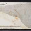
Prints and Drawings |
DC 26525 |
Audrey S Henshall |
Plan of chambered cairn (ARG 1) on graph paper |
1962 |
Item Level |
|
 |
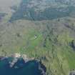
On-line Digital Images |
DP 076976 |
RCAHMS Aerial Photography Digital |
Oblique aerial view of Ockle point with Swordle Farm in the distance, taken from the NNW. |
1/6/2009 |
Item Level |
|
 |
On-line Digital Images |
DP 076977 |
RCAHMS Aerial Photography Digital |
Oblique aerial view of Ockle point with Swordle Farm in the distance, taken from the NW. |
1/6/2009 |
Item Level |
|
 |
On-line Digital Images |
DP 076978 |
RCAHMS Aerial Photography Digital |
Oblique aerial view of Swordle Farm, taken from the NNW. |
1/6/2009 |
Item Level |
|
|
Manuscripts |
MS 7355 |
Records of the Royal Commission on the Ancient and Historical Monuments of Scotland (RCAHMS), Edinbu |
J N G Ritchie Field notebook for Argyll II. |
1970 |
Item Level |
|
 |
On-line Digital Images |
SC 2382959 |
Records of the Ordnance Survey, Southampton, Hampshire, England |
Ardnamurchan, Cladh Aindreis, NM57SW 2, Ordnance Survey index card, page number 1, Recto |
c. 1958 |
Item Level |
|
 |
On-line Digital Images |
SC 2382960 |
Records of the Ordnance Survey, Southampton, Hampshire, England |
Ardnamurchan, Cladh Aindreis, NM57SW 2, Ordnance Survey index card, page number 2, Verso |
c. 1958 |
Item Level |
|
 |
On-line Digital Images |
SC 2382961 |
Records of the Ordnance Survey, Southampton, Hampshire, England |
Ardnamurchan, Cladh Aindreis, NM57SW 2, Ordnance Survey index card, Recto |
c. 1958 |
Item Level |
|
 |
On-line Digital Images |
SC 2382962 |
Records of the Ordnance Survey, Southampton, Hampshire, England |
Ardnamurchan, Cladh Aindreis, NM57SW 2, Ordnance Survey index card, Recto |
c. 1958 |
Item Level |
|
|
All Other |
551 166/1/1 |
Records of the Ordnance Survey, Southampton, Hampshire, England |
Archaeological site card index ('495' cards) |
1947 |
Sub-Group Level |
|


