
Ardnamurchan, Cladh Aindreis


Chambered Cairn (Neolithic), Cremation (Period Unassigned), Inhumation (Period Unassigned), Kerb Cairn (Prehistoric), Bead(S) (Jet)(Bronze Age)
Site Name Ardnamurchan, Cladh Aindreis
Classification Chambered Cairn (Neolithic), Cremation (Period Unassigned), Inhumation (Period Unassigned), Kerb Cairn (Prehistoric), Bead(S) (Jet)(Bronze Age)
Alternative Name(s) Allt Sordail; Swordle
Canmore ID 22360
Site Number NM57SW 2
NGR NM 5470 7076
Datum OSGB36 - NGR
Permalink http://canmore.org.uk/site/22360


- Council Highland
- Parish Ardnamurchan
- Former Region Highland
- Former District Lochaber
- Former County Argyll
NM57SW 2 5470 7076
(NM 5470 7076) Stone Cist found AD 1860 (NAT)
OS 1:10,000 map, (1974)
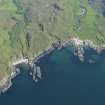
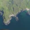
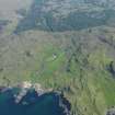
Chambered Cairn, Cladh Aindreis: This Clyde-type chambered cairn is situated on a terrace on the E bank of the Allt Sordail at a point some 500m N of Swordle. Aligned NW and SE, it measures about 47m in length, tapers in width from about 30m at its SE end to 6m at the NW end, and stands to a height of 0.5m. It has, however, not only been severely robbed to provide material for walls, but has also had field-gathered stones added to it, particularly at the SE end, and for these reasons its present shape is little guide to its original appearance.
At the SE end the remains of a chamber are visible, comprising two slabs of the S side, and of the N side and the end-slab. Aligned approximately E and W, the chamber has been rectangular on plan and has measured at least 3m by 0.8m. It has been divided into two compartments, but, although three stones of the inner compartment still survive, only one side-slab of the outer compartment is visible. The end-slab of the inner compartment stands to a height of 1.05m above the present floor-level of the chamber.
Sources: A S Henshall 1972, visited 1962; RCAHMS 1980, visited 1972.
This mutilated chambered cairn was in a similar condition when seen in 1970.
Surveyed at 1:2500.
Visited by OS (N K B) 12 June 1970.
Excavation (July 2006 - August 2006)
NM 547 707 A small-scale evaluative survey of Swordle Bay was undertaken during July and August 2006 by the Ardnamurchan Transitions Project, including detailed survey at the site of Cladh Aindreis, and excavation of the tomb forecourt, outside the scheduled area. This work was undertaken for two reasons: to assist in developing a detailed excavation strategy for future seasons and to provide a preliminary contribution towards the wider project aims of establishing the date, form and chronological sequence of the cairn and chamber. An additional objective was to begin to define the boundaries of the monument, its relation to other sites within a 2km radius, and to record the palaeoenvironmental setting of the site. At Cladh Aindreis, we removed all vegetation from the cairn and surrounding area, planned the cairn and photographed relevant parts of the structure. In the forecourt of the tomb, outside the scheduled area, we opened a trench (Trench 1) in which robbed material from the cairn was identified in the upper subsoils. Beneath these upper deposits we found a stained gravel surface into which two pits were cut. One was amorphous in shape, and possibly represented two pits. It disappeared into the trench edge towards the scheduled area, and so its extent was not established. Another was sub-oval and had been repeatedly recut and subjected to burning activity. A compact stained and humic layer at the base of this pit suggested that it may have been lined with turf or other organic matter. A sample of carbonised wood was recovered from this pit and has been sent away for radiocarbon dating. No diagnostic finds were noted within Trench 1, although a broken flint blade was found in the upper subsoils, with retouch on both sides of its proximal end. Large quantities of quartzite, both in chipped form and as river-rolled pebbles, were found within all contexts. Some tiny flint waste flakes possibly representing debitage were also found.
We opened another trench to the WNW of the cairn, on a lower terrace of the Swordle River. Here a small area of rig and furrow field system was observed to be respecting a discrete circular stone structure, which appeared to be artificially raised above the natural lay of the land on its western (river-facing) side. Excavation suggested that this was a small circular structure set into the beach gravels, and respected by the rig and furrow. However, only _ of the structure was revealed in an area that may have been subject to more recent robbing activity.
A report has been lodged with the NMRS and Highland SMR. The archive is intended for deposition in the NMRS.
Sponsor: The Prehistoric Society; the Council for British Archaeology Challenge Fund; the University of
Manchester Students as Partners Fund; the School of Historical Studies, University of Newcastle; the University of Manchester.
P Richardson and H Cobb 2006
Excavation (24 June 2007 - 8 July 2007)
NM 5470 7076 Three trenches were opened at the chambered tomb of Cladh Aindreis in Swordle Bay, as well as numerous test pits to the S of the cairn. Work took place from 24 June - 8 July 2007. Our work aimed to provide information about the sequence of tomb construction, and later robbing activity. We also hoped to explore further the relationship between the cairn itself and the activity in its forecourt, immediately S of the front of the cairn. Two small trenches in the centre of the cairn confirmed the badly robbed-out nature of the cairn and offered tantalising insights into the cairn sequence. A single piece of prehistoric pottery was found among tumbled cairn material. A trench at the front of the cairn revealed a large ditch, containing prehistoric
flints, c7m from the cairn's chamber. The ditch continued out of the both the E and W trench baulks and appeared to curve to the E. However, the full extent of this ditch was not revealed. A hearth uncovered in 2006 was fully excavated but no finds were present.
Funder: Manchester University, Newcastle University, Prehistoric Society, Royal Archaeological Institute, Glasgow Archaeological Society, CFA Archaeology Ltd, Council for British Archaeology Challenge Fund, University of Central Lancashire, The Russell Trust.
Excavation (23 August 2009 - 5 September 2009)
NM 5470 7076 Excavations at Cladh Aindreis chambered cairn began in 2006, focusing on the cairn’s structural sequence and landscape relationships. In 2009 Historic Scotland once again kindly granted permission for the excavation of three trenches and work took place from 23 August–5 September 2009.
Trench 1 was expanded into the forecourt of the cairn. Previous years’ excavations in Trench 1 have aimed to find the front of the cairn; however, no evidence of any structural cairn material has been recorded. Instead, the excavation has revealed packing material, which is thought to relate to the blocking of the cairn in its final phases of use in the Neolithic. The 2009 excavations confirmed this interpretation, with layers of earth and gravel, containing fragments of pottery and bone, blocking a curved façade, similar to many other Clyde cairns. Having helped to identify the ‘front’ of the monument in 2010 an extension to this trench will clarify its shape and investigate whether the chamber was accessible from this direction.
Trench 9 was opened immediately behind the chamber in the centre of the monument and aimed to determine if the cairn was constructed on a shell midden. However, while the intention was to excavate through cairn material, what appeared to be a possible ‘closed cist’ was encountered and excavations were stopped pending further consultation with Historic Scotland. Probable Neolithic pottery was also recovered from this trench.
Trench 4 was re-opened following the discovery of a possible entrance to a structure in 2008. The trench revealed a complex sequence of structures which are yet to be fully resolved. However, the results of the 2009 season appear to show that a kerbed cairn was built on the SW corner of the chambered cairn. Later, what appears to be a square cellular structure was built on top of the kerb cairn with a possible long cist inserted into the entrance of the cellular structure. A full dating and post-excavation programme is under
way which aims to resolve some of these issues. Further excavations are planned for 2010.
Archive: Highland SMR and RCAHMS (intended)
Funder: University of Manchester, McDonald Institute for Archaeological Research and CFA Archaeology Ltd
Hannah Cobb, Hèlèna Gray, Oliver Harris and Philip Richardson – University of Manchester/University of Cambridge and University of Newcastle
Excavation (15 August 2010 - 4 September 2010)
NM 5470 7076 Work undertaken 15 August–4 September 2010 consisted of the excavation of three trenches at Cladh Aindreis chambered tomb in Swordle Bay and two trenches at the post-medieval settlement of Coldstream Cottage to the N of the bay.
At Cladh Aindries, Trench 1 revealed both a recent ‘robber’ trench and in situ blocking at the front of the
cairn. In the gravel blocking small fragments of cremated bone were found together with fragments of unburnt bone. A fragmented crouched inhumation, probably from the Beaker period and a series of discrete concentrations of disarticulated but tightly packed remains, most likely dating to the Neolithic, were also discovered in what appears to be a damaged front chamber. This chamber was damaged in antiquity, probably after the stone box containing the Beaker burial was inserted, and the chambers of the cairn were blocked off to prevent further access, culminating in a capping of small stones.
In Trench 9 evidence of a cremation that preceded the monument, as well as bones from a circular cist were
recovered. It is hoped that these remains will provide a chronology for the site unparalleled in mainland Scotland. In Trench 4 the putative Bronze Age kerb cairn partially revealed in 2009 was fully exposed and planned. Excavations of the NW quadrant uncovered a central cist which included a burial and several beautiful jet beads, perhaps imported from Whitby in N Yorkshire. These are classic Early Bronze Age fusiform beads which probably started out life as part of a spacer plate necklace (Alison Sheridan pers. comm.). The cairn has been named Ricky’s Cairn, in honour of the local volunteer who first noticed it.
At Coldstream Cottage excavations of two trenches at a post medieval settlement site, believed to have been cleared prior to the middle of the 19th century, revealed a complex set of stone remains that may predate the expected remains. Further excavations in 2011 will help resolve this issue.
Archive: Highland Council Archaeology Unit, NMS and RCAHMS (intended)
Funder: Ardnamurchan Estate, University of Manchester, University of Newcastle, Prehistoric Society, Royal Archaeological Institute, Glasgow Archaeological Society, CFA Archaeology Ltd, Council for British Archaeology Challenge Fund, University of Central Lancashire, The Russell Trust and McDonald Institute of Archaeological Research
Oliver Harris, Hannah Cobb, Héléna Gray and Phil Richardson – University of Newcastle and University of Manchester
Excavation (10 July 2011 - 29 July 2011)
NM 54200 70500 Excavations in Ardnamurchan by the Ardnamurchan Transitions Project began in 2006 and the project has excavated sites from the Neolithic, Bronze Age, Iron Age and post-medieval periods as part of our attempt to characterise the changing forms of occupation within Swordle Bay on the peninsula's northern coast.
The 2011 season, which ran from 10–29 July, saw the excavation of a Viking boat burial. This consisted of a boat shaped cut, 5.1 x 1.5m, containing good evidence of the boat itself (in the shape of 150+ rivets 3Dimensionally recorded) and multiple grave goods including an axe, a sword, a spear, a shield boss, a bronze ring pin, a knife, a possible rim of a drinking horn (bronze), a ladle-like implement, a whetstone, Viking grass-tempered pottery and many other pieces of iron we have yet to identify. Although the body had mostly rotted away, we were fortunate that a few fragments of bone and two teeth survived, confirming the presence of the body in the grave at the time of burial. This was totally unexpected, as were looking to excavate what looked like a clearance cairn, close to the Neolithic tomb of Cladh Aindreis. A full conservation and post excavation process is now under way.
Excavations continued at Coldstream Cottage where small trenches in four structures were excavated. These excavations recorded evidence for the reuse and abandonment of all four structures. At least two kinds of structure were present, which seem to date from two separate periods of occupation, Structure 1 being earlier than 2 4. More analysis is needed but it certainly seems to be the remains of one of the Swordle townships that were cleared in the 1850s. The finds from here were almost exclusively post-medieval. Structure 1 contained two sherds of potentially medieval pottery.
Test pits were excavated along the outcrop at Dun Mhurchaidh in order to uncover evidence of use and dating material. The test pits recorded some evidence for metalworking, slag, lots of burning etc, but no associated structures, other than two possible stone platforms. A posthole containing animal bones at its base was found next to one of these platforms. Towards the possible entrance, a putative ditch was uncovered in a test pit, sealed by a major burning event. The finds included polishing/burnishing stones, slag, an amber bead and part of a shale bracelet.
A series of test pits were also excavated along a wave-cut platform forming part of the Swordle Valley. These test pits revealed only a few finds of post-medieval date, identified within either topsoil or hillwash deposits. In addition, a trench was excavated across two dry stone wall field boundaries, to examine their construction and identify any possible earlier structural and dating evidence.
Archive: Highland HER, NMS and RCAHMS (intended)
Funder: Ardnamurchan Estate, Manchester University, Newcastle University, Prehistoric Society, CFA Archaeology Ltd, British Academy and Leverhulme Trust
Manchester University and Leicester University, 2011
Excavation (20 July 2014 - 9 August 2014)
NM 5470 7076 The Ardnamurchan Transitions Project (ATP) is a long running research and community project exploring the archaeology of the Ardnamurchan Peninsula. While research into the archaeology of much of Western Scotland has been intensive over the last few decades, the Ardnamurchan Peninsula remains a relatively understudied area.
Consequently, little is known of key periods and transitions in lifeways, from hunting and gathering to farming, to the arrival of metalworking in the area, to the developments of the Iron Age, the coming of the Vikings and subsequent changes in lifeways in the medieval and post-medieval periods, including the Highland Clearances. As such, the ATP aims to investigate these key transformations in the area through a combination
of site specific excavation and wider survey work.
Since 2006 the project has focused on Swordle Bay on the N coast of the peninsula. To date we have excavated six sites from five different periods: Cladh Aindreis from the Neolithic (DES 2010); Ricky’s Cairn from the Bronze
Age (DES 2010); the Iron Age promontory fort of Dun Mhurchaidh (DES 2012); a 10th-century Viking boat burial (DES 2011) and the post-medieval settlements of Swordle Corrach and Swordle Huel (DES 2011, 2012, 2013). The extent of activity at Dun Mhurchaidh, and the sites of Ricky’s Cairn and the Viking boat burial were all unknown prior to our work in the area. Our work has also included an initial radiocarbon dating programme of these monuments, and an intensive walkover survey, which has identified a number of previously unrecorded sites, and a geophysical survey.
The 2014 season, which ran 20 July – 9 August 2014 focused on Cladh Aindreis and Ricky’s Cairn. Our work to date at Cladh Aindreis, and post-excavation analysis, has shown that previous assumptions that the cairn dated exclusively to the Neolithic, and that the cairn was an Early
Neolithic Clyde Cairn vastly understate the complexity of the site. Radiocarbon dates do put the construction of the monument in the Early Neolithic (3700 BC), which is typical of Clyde Cairns, but the morphology of the monument changed significantly over time, including the construction
of a Bronze Age kerbed cairn (Ricky’s Cairn) abutting Cladh Aindreis, and an intervention of some sort, which may have taken place during the Viking period, as suggested by a Viking bead found in a ‘robber’ trench, which was cutting the Neolithic chamber in the cairn. Our work in 2014 aimed to
investigate three key areas to further elucidate the sequence of construction and use of Cladh Aindreis and Ricky’s Cairn.
Three trenches were opened. The first was located over the visible chamber of Cladh Aindreis where the Viking bead had been found. A second trench was located over the unexcavated portion of the cist of Ricky’s Cairn. This was only partially excavated in 2010 due to the constraints of our scheduled monument consent at the time. We therefore
wanted to fully excavate the cist to better understand the nature of the funerary deposits and the treatment of the body. Finally, a large trench, in which we had permission to strip and map only, was opened over the ‘tail’ end of Cladh Aindreis to investigate the form of the deposits, and to establish if these are indicative of particular phases of construction.
Viking intervention at Cladh Aindreis: Disappointingly, this trench had been extensively robbed in the postmedieval period, as evidenced by modern material culture and extensive deposits of modern fence wire. The postmedieval cut itself cut the potential cut [175] associated with the Viking bead. All deposits, including those within the Neolithic chamber itself, were significantly disturbed and redeposited, and the multiple later interventions mean that understanding the sequence in this part of the chamber of Cladh Aindreis is impossible. However, this trench did yield
important information about the construction of the main chamber, demonstrating it was an integral part of the initial circular mound.
The Cist of Ricky’s Cairn: The cist was excavated in full. In 2010 four jet beads had been found in this cist, and a further bead was found in 2014. In 2010 disarticulated human remains had been found and the presence of one individual had been established in osteological post-excavation analysis. This was dated to 1700 cal BC by radiocarbon dating. Our excavations in 2014 found further disarticulated remains, which indicated
that a minimum of two individuals were interred in the cist as depositions of disarticulated remains. This is somewhat unusual for the Bronze Age, where single (and usually articulated) internments are often perceived to be the norm. It joins an increasing body of evidence for these kinds of
practices in the second millennium BC. Also of note is that the four stones making the sides of the cist were each from the different geological types within the Bay.
The Tail of Cladh Aindreis: The exercise of stripping and mapping this section of the monument raised more questions than it answered. Rather than revealing a straightforward and uniform tail of cairn material, it appears that several phases of construction (and reuse) are likely. The very end of the cairn is very likely Neolithic because we found this to be respected by a small (1.0 x 0.5m) robbed out, but typologically Bronze Age, cist on its E side, indicating the tail predated this. In this very end section a potential further chamber on a NE–SW alignment was noted, with large
limestone stones suggesting this may have similarities with the visible chamber at the front (SW) end of the cairn. In the central section, the cairn construction indicated a circular structure had been present with a central box hearth or further cist, suggesting further potential Bronze Age reuse.
However, our understanding of this phasing was limited both by the fact that we could only strip and map the monument (due to the limitations of our SMC), and also complicated by a further phase of reuse in which a potential medieval or post-medieval flue, and perhaps kiln, may have been
constructed within the monument itself. Without intrusive excavation it is impossible to confirm any of these potential structural elements or their specific phases.
Archive: RCAHMS and Highland HER (intended)
Funder: The University of Manchester, The University of Leicester, The University of Cambridge and Viking River Cruises
Hannah Cobb, Héléna Gray, Oliver Harris and Phil Richardson - Manchester University, Leicester University, Archaeology Scotland and CFA Archaeology Ltd
(Source: DES)

