
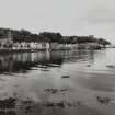
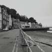
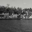
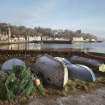
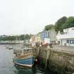
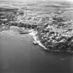
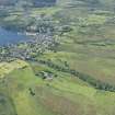
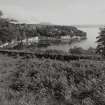
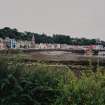
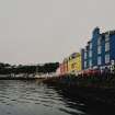
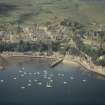
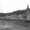
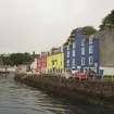
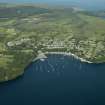
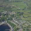
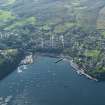
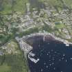
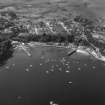
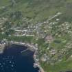
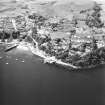
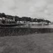
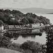
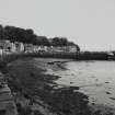
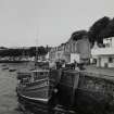
Mull, Tobermory


Burgh (Medieval), Town (Period Unassigned)
Site Name Mull, Tobermory
Classification Burgh (Medieval), Town (Period Unassigned)
Alternative Name(s) Tobar Mhoire
Canmore ID 22322
Site Number NM55NW 6
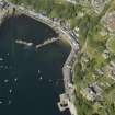
NGR NM 5053 5530
NGR Description Centred NM 5053 5530.
Datum OSGB36 - NGR
Permalink http://canmore.org.uk/site/22322


- Council Argyll And Bute
- Parish Kilninian And Kilmore
- Former Region Strathclyde
- Former District Argyll And Bute
- Former County Argyll
NM55NW 6 centred 5053 5530
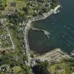
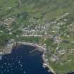
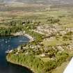
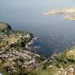
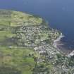
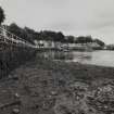
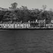
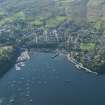
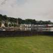
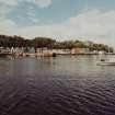
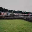
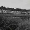
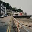
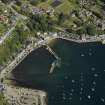
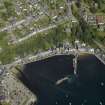
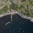
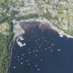
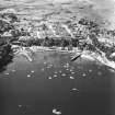
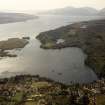
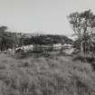
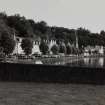
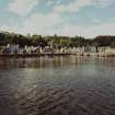
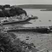
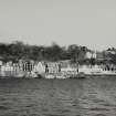
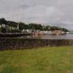
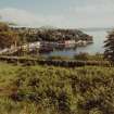
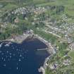
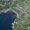
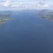
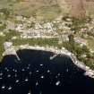
An agrarian settlement of Tobermory was located on high ground W of the medieval chapel and the well from which it took its name (NM55NW 2 and NM55NW 3 at NM 501 553), and about 450m from the NW shore of the bay.
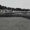
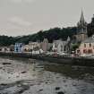
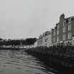
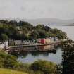
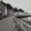
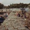
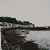
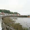
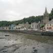
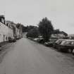
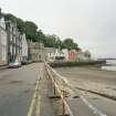
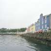
The development of the present town of Tobermory (which lies SE and E of the chapel) started in 1788. A full description of the later expansion of the town is given by the RCAHMS.
RCAHMS 1980, visited 1976.
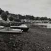
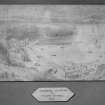
Mull, Tobermory, general.
SRO:
Sketch of the shore and the bank. Drawn in pen it illustrates the proposed position for the Custom House and for the Controller and Surveyor's Lodging. The positions of the previous [GD 9/4/294] sketches of cross-sections are marked. Submitted by James Maxwell.
1789 GD 9/4/296
Pen and pencil sketch of proposed buildings sent to James Maxwell.
N/D. GD 9/4/117.
Letter to the Duke of Argyll. It accompanied plans, papers and estimates for work at Tobermory and Ullapool. They are listed with their authors at the end of the letter which is from John Mackenzie.
1788 GD 9/4/87.
Robert Mylne's plans of the Custom House are to be considered at the business meeting of the British Fishery Society.
1789 GD 9/4/163.
1789 GD 9/4/163.
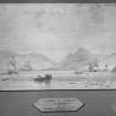
Sketch in pen and pencil of 'the Harbour of Tobermorrey' according to the design mentioned in the Society's advertisement.
ND GD 9/4/219.
Sketch in pen and pencil of 'the Harbour Tobermorrey' according to the design recommended by James Maxwell.
ND 9/4/217.
Robert Mylne's plans of the Custom House are to be considered at the business meeting of the British Society.
1789 GD 9/4/165.
Duke of Argyll's letter expresses the Society's opinion of Mr Mylne's and Mr Maxwell's sketches of proposed Customs House. Mr Maxwell's plan is less elegant and commodious but cheaper and wil probably be adopted.
1789 GD 9/4/251.
Sketch showing design for a port and village which has been projected and partly built at the British Society's station of Tobermory. Drawn by James Maxwell.
1790 GD 9/3/635.
Sketch in pen and wash of two cross sections of the bank at Tobermory. It illustrates the position of breast and buttress. Submitted by James Maxwell with a covering letter.
1789 GD 9/4/294.
1. Front elevation of the Inn. 2. Plan of garret floor. Executed in pen and colour wash by Mr Mylne, architect.
1790 GD 9/4/444.
James Maxwell's plan for the conversion of the House at Baliscate into a schoolroom is passed by Mr Telford and approved of by the British Society.
1794 GD 9/4/559.
Secretary's letter to the Duke of Argyll. It accompanied 7 packets of plans and estimates which included:
Robert Mylne's report and observations, Messrs Rogers and richardson's plans and estimates for Tobermory, and copies of Mr Morison's and Mr Mylne's plans, elevations and sections for Inn and Warehouse at Ullapool.
1788 GD 9/8/50.
The packets were as follows: [listed at end of letter to the Duke]
1. Report and observations on the plans and estimates by Robert Mylne [he prefers Mr Morison's plans for Ullapool's Inn and Warehouse to that of Tobermory].
2 & 3. 1st and 2nd parts of plans and estimates for Tobermory by Messrs Rogers and Richardson.
4. Estimates for Tobermory supposed by Mr Langlands.
5. Estimates from Oban and also minute of Mr Beaufoy's and Mr Coll's opinions on Mr Morison's plans.
6. Mr Udney's estimates for both Tobermory and Ullapool.
7. Copies of Mr Morison's and Mr Mylne's plans, elevations and sections for Inn and Warehouse at Ullapool.
Directors of British Society have approved Robert Mylne's plan of an Inn for Tobermory. The plan is sent to Thomas Telford so that he and James Maxwell may make alterations in the light of local circumstances.
1790 GD 9/8/166.
Plan, done in pen and wash of an inn. It shows a ground floor and upper storey and is drawn by Mr Mylne, architect.
1790 GD 9/4/441.
British Society orders a copy of Brook's 'Plan of the Society's Land at Tobermory', to be made for Dr Coventry. A copy of Mr Langland's plan of the village of Tobermory and of the garden is also required.
1793 GD 9/4/523.
[Dr Coventry was Professor of Agriculture at Edinburgh University]
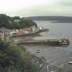
Survey and report concerning progress of the works at Tobermory. It was carried out by Thomas Telford and covers harbour, customs house, inn and storehouse.
1790 GD 9/3/551-574.
Ground plan of an inn followed by detailed estimates requested through Thomas Telford for the British Society. Original plan was that of Mr Maxwell and Telford's alteration are minor [ref. p559].
GD 9/3/568-571.
Sketch showing design for a port and village which has been projected and partly built at the British Fishery Society's station of Tobermory. Drawn by James Maxwell.
1790 GD 9/3/635.
Mull, Tobermory, Schoolhouse.
SRO:
Schoolhouse to be completed by James Nesbett. Finance for the purpose promised by the wealthier inhabitants because the British Society had been unable to sanction the expenditure.
1831 GD 9/18/280.
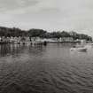
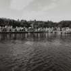
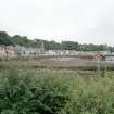
Photographic Record (1906)
Photographs taken during a visit by the Churches Commission in July 1906.
The photographs are available in PA 71.

