
Following the launch of trove.scot in February 2025 we are now planning the retiral of some of our webservices. Canmore will be switched off on 24th June 2025. Information about the closure can be found on the HES website: Retiral of HES web services | Historic Environment Scotland
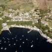
Mull, Tobermory, St Mary's Chapel And Burial-ground


Burial Ground (Period Unassigned), Chapel (Period Unassigned), Font (Period Unassigned)(Possible), Saddle Quern (Period Unassigned)
Site Name Mull, Tobermory, St Mary's Chapel And Burial-ground
Classification Burial Ground (Period Unassigned), Chapel (Period Unassigned), Font (Period Unassigned)(Possible), Saddle Quern (Period Unassigned)
Canmore ID 22318
Site Number NM55NW 2
NGR NM 5019 5532
Datum OSGB36 - NGR
Permalink http://canmore.org.uk/site/22318


- Council Argyll And Bute
- Parish Kilninian And Kilmore
- Former Region Strathclyde
- Former District Argyll And Bute
- Former County Argyll
NM55NW 2 5019 5532.
(NM 5019 5532) St Mary's Chapel (NR) (rems of)
OS 1:10,000 map, (1976)
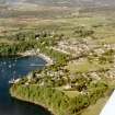
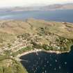
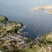
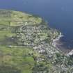
St Mary's Chapel, Tobermory: The fragmentary remains of this medieval chapel are situated within an extensive burial ground some 400m W of Tobermory Harbour. Although the earliest record is in a crown rental of 1509, it was stated in a similar document of 1542 that certain lands in Mull had belonged to the chapel of Our Lady 'from the time of its foundation, long ago'.
The only identifiable remains of the chapel are the lower courses of the E and N walls, some 0.9m in thickness, and a turf-covered mound marking the line of the S wall. The internal width was about 5.3m and the length from E to W was not less than 9.1m; the W end of the structure is overlain by later family burial-enclosures, and the position of the W gable cannot be ascertained. A saddle-quern, popularly identified as a font, is fixed on a modern base at the E end of the chapel.
Two late medieval tombstones lie within the chapel while part of another has been reused as a headstone some 20m N of the chapel. All (fully described by the RCAHMS) date approximately to between 1500 and 1600.
RCAHMS 1980, visited 1974.
The remains of St Mary's Chapel were in a similar condition to that described by the RCAHMS when seen in 1972.
Surveyed at 1:2500.
Visited by OS (D W R) 20 April 1972.
Field Visit (31 July 1942)
This site was included within the RCAHMS Emergency Survey (1942-3), an unpublished rescue project. Site descriptions, organised by county, vary from short notes to lengthy and full descriptions and are available to view online with contemporary sketches and photographs. The original typescripts, manuscripts, notebooks and photographs can also be consulted in the RCAHMS Search Room.
Information from RCAHMS (GFG) 10 December 2014.

