Pricing Change
New pricing for orders of material from this site will come into place shortly. Charges for supply of digital images, digitisation on demand, prints and licensing will be altered.
Killundine, Cill Fhionntain
Burial Ground (Post Medieval), Chapel (Medieval)
Site Name Killundine, Cill Fhionntain
Classification Burial Ground (Post Medieval), Chapel (Medieval)
Alternative Name(s) Cill Leuntaig; Killundine, Chapel
Canmore ID 22256
Site Number NM54NE 1
NGR NM 5795 4987
NGR Description NM 5795 4987 and NM 5790 4987
Datum OSGB36 - NGR
Permalink http://canmore.org.uk/site/22256
- Council Highland
- Parish Morvern
- Former Region Highland
- Former District Lochaber
- Former County Argyll
Field Visit (6 July 1943)
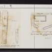
This site was included within the RCAHMS Emergency Survey (1942-3), an unpublished rescue project. Site descriptions, organised by county, vary from short notes to lengthy and full descriptions and are available to view online with contemporary sketches and photographs. The original typescripts, manuscripts, notebooks and photographs can also be consulted in the RCAHMS Search Room.
Information from RCAHMS (GFG) 10 December 2014.
Field Visit (9 June 1970)
When seen in 1970, the remains of the chapel were in a condition similar to that described by the RCAHMS.
The grave markers were found in 1970, at NM 5793 4987, inside the W corner of the burial ground (now disused) They were found prostrate beside the graveyard wall and were probably brought from elsewhere.
Surveyed at 1:10,000.
Visited by OS (R L) 9 June 1970.
Desk Based Assessment (1970)
NM54NE 1 5795 4987 and 5790 4987.
(NM 5790 4987) Chapel (NR) (rems of)
OS 1:10,000 map, (1976)
Cill Leuntaig (NR)
OS 6" map, Argyllshire, 2nd ed., (1900)
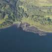
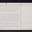
Chapel and Burial-ground, Killundine: The burial-ground at Killundine (at NM 5795 4988), which contains the 19th-century burial-enclosure of the family of Cheape of Killundine, is of recent origin. However, (at NM 5790 4987) on a low knoll some 30m to the W, there are the turf-covered remains of a rectangular building which measures about 7.6m from E to W by 3.0m transversely within 0.7 m walls standing to a maximum height of 0.8m. A gap at the centre of the S wall may mark the position of the entrance-doorway. This structure stands in the NW angle of a small D-shaped enclosure, defined on the N and W sloping ground, and on the E and S by a curving stony bank.
Although the name 'Cill Leuntaig' was applied to this site by the OS in the 19th century, its Gaelic name is 'Cill Fhionntain, the dedication being to St Fintan. The orientation and plan-form of the building described above suggest that it was a chapel, but in view of its elongated proportions it must be attributed to the medieval period, although the site was evidently in use at an earlier date.
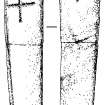
Two Early Christian grave-markers from the burial-ground are at present in the care of Mr Iain Thornber, Ardtornish. One, which is in two pieces, has been a roughly-shaped pillar measuring 1.43m high, 0.24m
in maximum width and 0.065m thick; it has an incised cross on both faces, the edges being plain. The other stone measures 0.64m high, 0.12m in maximum width and from 0.05m to 0.09m in thickness; the foot has been roughly trimmed to a point and there is an incised cross on one face only.
OS Name Book 1872; W J Watson 1926; I Thornber 1974; RCAHMS 1980.
Information from OS.
Field Visit (March 1974)
The burial-ground at Killundine, which contains the 19th-century burial-enclosure of the family of Cheape of Killundine, is of recent origin. On a low knoll some 30m to the W, however are the turf-covered remains of a rectangular building which measures about 7.6m from E to W by 3.0m transversely within 0.7m walls standing to a maximum height of 0.8m. A gap at the centre of the S wall may mark the position of the entrance-doorway. This structure stands in the NW angle of a small D-shaped enclosure, defined on the N and W by sloping ground, and on the E and S by a curving stone bank.
Although the name 'Cill Leuntaig' was applied to this site by the Ordnance Survey in the 19th century, its Gaelic name is 'Cill Fhionntain', the dedication being to St Fintan. The orientation and plan-form of the building described above suggest that it was a chapel, but in view of its elongated proportions it must be attributed to the medieval period, althought the site was evidently in use at an earlier date.
Visited by RCAHMS, May 1974


