
Pricing Change
New pricing for orders of material from this site will come into place shortly. Charges for supply of digital images, digitisation on demand, prints and licensing will be altered.
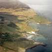
Eigg, Kildonnan


Font (Medieval)(Possible), Human Remains (Medieval), Basin (Stone)(Period Unassigned)
Site Name Eigg, Kildonnan
Classification Font (Medieval)(Possible), Human Remains (Medieval), Basin (Stone)(Period Unassigned)
Alternative Name(s) Kildonan
Canmore ID 22151
Site Number NM48NE 18
NGR NM 4883 8540
Datum OSGB36 - NGR
Permalink http://canmore.org.uk/site/22151


- Council Highland
- Parish Small Isles
- Former Region Highland
- Former District Lochaber
- Former County Inverness-shire
Note (1928)
NOTE.
In a contribution to the Proceedings of the Society of Antiquaries on March 11, 1878 (vol. xii., 577-597), mention is made of the following additional monuments:
(1) "Foundations of an island dwelling" in a small loch "lying high up on the shoulder of the Scuir of Eigg, known as Lochan na Mna Moire." The island is apparently that in Lochnam Ban Mora (O.S. 6-inch), the only loch here which has an island; it is inaccessible without a boat.
(2) A cairn, "some five or six hundred yards south from Kildonnan," which provided on excavation the articles in [RCAHMS 1928] No. 2 of list on p. lvi.
(3) A cairn "a few yards further south" with articles in No 3.
(4) Cairn, "Sithean or Sguman-nan-Cailleach," containing "two cists . . . made of flat stones set on edge and laid length wise." Stones of cairn removed to fill up a drain. Sithean na Cailleich on O.S. 6-inch lxxi
The O.S. map 6-inch lxxiii. notes a stone cist just north of Kildonnan Old Church ("Ruins of Chapel," cf. Proc. Soc. Ant. Scot., as above, pp. 584-6); the site of one stone cist found in 1861, and of another in 1864, in Galmisdale; the sites of two crosses (lxxi., lxxii.) and Tobar Challuim Chille ("Columba's Well") in Cleadale (lxxi).
RCAHMS 1928
Desk Based Assessment (12 January 1966)
NM48NE 18 4880 8542
(NM 4880 8542) Stone Cist (NR)
OS 6" map (1903)
Martin describes the finding of a "sepulchral urn" of stone, almost full of human bones, about 30 yds from St Donnan's Chapel. It was about 4' deep and the same broad, and covered by a thin flat stone. MacPherson, in 1878, refers to a stone basin (probably a font or piscina) situated c.60 yds N of the chapel lying just below ground surface, which when investigated, was found to contain mainly earth and a few human bones. This was c.3' across, but only 6" - 7" deep, which suggests it was either a different "urn" or that Martins's measurements were quite inaccurate.
An elderly local informant remembered that soon after 1818 this hollowed stone, and another also full of bones, had been dug up and removed to the edge of the field where they remained for some months exposed. In these circumstances, the find does not appear to be in its original position.
N MacPherson 1878; M Martin 1934.
Note (17 March 1972)
About 1' under the surface of the earth is a stone coffin generally supposed by the community at large to be the grave of St Donnan.
Name Book 1877.
Field Visit (9 May 1972)
No trace, and no local knowledge of the position of this "font".
Visited by OS (AA) 9 May 1972.

