
Eynhallow


Clearance Cairn (Post Medieval)(Possible), Farmstead (Medieval) - (Post Medieval)(Possible), Mound (Period Unknown)
Site Name Eynhallow
Classification Clearance Cairn (Post Medieval)(Possible), Farmstead (Medieval) - (Post Medieval)(Possible), Mound (Period Unknown)
Canmore ID 2182
Site Number HY32NE 30
NGR HY 3582 2887
Datum OSGB36 - NGR
Permalink http://canmore.org.uk/site/2182


- Council Orkney Islands
- Parish Rousay And Egilsay
- Former Region Orkney Islands Area
- Former District Orkney
- Former County Orkney
Desk Based Assessment (22 February 1971)
HY32NE 30 3582 2888.
HY 3585 2882. There is a kitchen-midden some 50yds. W of the chapel (HY32NE 2).
Information from OS (WDJ) 22 February 1971
Source: RCAHMS 1946, visited 1929.
Field Visit (16 October 1972)
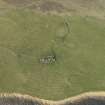
HY 3582 2888. The alleged midden consists of an amorphous turf-covered stony mound about 11.0m in diameter, which appears to be a field clearance heap probably contemporary with the rig and furrow cultivation around it. No midden material is visible.
Visited by OS (AA) 16 October 1972.
Field Visit (August 1982)
Eynhallow HY 3582 2888 HY32NE 30
On the hillside level with the monastery and some 60m NW of it is a shapeless, nettlegrown mound some 11m across. It has been claimed to be a kitchen-midden, but this cannot now be verified; the general appearance suggests a field-clearance and general rubbish heap.
RCAHMS 1982, visited August 1982
(RCAHMS 1946, ii, p. 234, No. 617; OR 774)
Ground Survey (25 April 2007 - 29 April 2007)
HY 36041 29076 A desk-based assessment and walkover survey of the island of Eynhallow was undertaken in April 2007. A total of 65 sites were recorded, ranging from post-medieval buildings to prehistoric structures. Of particular interest was the identification of a previously unrecorded burnt mound in the N of the island, several possible prehistoric burial mounds and a well preserved sequence of field dykes. Although further work is required to understand these boundaries, initial assessment suggests there is clear phasing and chronological depth to these features which may include potential prehistoric land divisions.
Report to be deposited with the Orkney SMR and RCAHMS.
Funder: Hunter Archaeological Trust, Viking Society for Northern Research, Orkney Archaeological Trust, Orkney College Geophysics Unit.
Field Visit (12 August 2015)
This grass-grown mound situated roughly 90m WNW of Eynhallow Church and surrounded by the remains of rig and furrow measures about 15m in diameter and stands about 1m high. Although it has been previously identified as a kitchen midden (RCAHMS 1946, 234) and a clearance cairn (OS 1972), the presence of stones beneath the surface and indications of walling suggest that this may be the site of West House, a small farmstead known from documentary sources (Moore and Thomas 2008, 17; Orkney Archive Reference D1/440/1).
Visited by RCAHMS (GFG) 12 August 2015

