 |
On-line Digital Images |
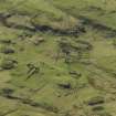
DP 027316 |
RCAHMS Aerial Photography Digital |
Oblique aerial view centred on the remains of the township and lazy beds, taken from the E. |
26/4/2007 |
Item Level |
|
 |
On-line Digital Images |
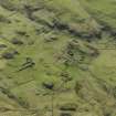
DP 027317 |
RCAHMS Aerial Photography Digital |
Oblique aerial view centred on the remains of the township and lazy beds, taken from the NE. |
26/4/2007 |
Item Level |
|
 |
On-line Digital Images |
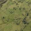
DP 027318 |
RCAHMS Aerial Photography Digital |
Oblique aerial view centred on the remains of the township and lazy beds, taken from the NNW. |
26/4/2007 |
Item Level |
|
 |
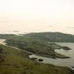
On-line Digital Images |
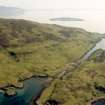
SC 1864399 |
Papers of James Sloan Bone, landscape historian, Inverness, Highland, Scotland |
Aerial view of Gometra and Ulva, off Isle of Mull, looking SW. |
1990 |
Item Level |
|
 |
On-line Digital Images |
SC 1864402 |
Papers of James Sloan Bone, landscape historian, Inverness, Highland, Scotland |
Aerial view of West Ulva and Gometra, Isle of Mull, looking SSW. |
1990 |
Item Level |
|
 |
On-line Digital Images |
SC 2381784 |
Records of the Ordnance Survey, Southampton, Hampshire, England |
Gometra, Bail' A' Chlaidh, NM34SE 7, Ordnance Survey index card, Recto |
c. 1958 |
Item Level |
|
|
All Other |
551 166/1/1 |
Records of the Ordnance Survey, Southampton, Hampshire, England |
Archaeological site card index ('495' cards) |
1947 |
Sub-Group Level |
|


