
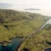
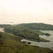
Gometra, Bail' A' Chlaidh


Lazy Beds (Post Medieval), Township (Period Unassigned)
Site Name Gometra, Bail' A' Chlaidh
Classification Lazy Beds (Post Medieval), Township (Period Unassigned)
Canmore ID 21819
Site Number NM34SE 7
NGR NM 3722 4096
NGR Description Centred on 3722 4096
Datum OSGB36 - NGR
Permalink http://canmore.org.uk/site/21819


- Council Argyll And Bute
- Parish Kilninian And Kilmore
- Former Region Strathclyde
- Former District Argyll And Bute
- Former County Argyll
NM34SE 7 centred on 3722 4096
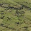
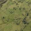
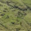
At least sixteen roofless buildings and associated enclosures. Deserted settlement visible on OS air photographs OS/71/337-762. Date of depopulation c. 1851. Name not known.
Visited by OS 15 May 1972
Crucks noted at NM 373 408. [May refer to one or more buildings within this group].
G Stell 1981
Recent fieldwork by the staff of the Strathclyde Joint Archaeology Service (funded by Strathclyde Regional Council and its constituent District Councils) has resulted in the discovery and recording of a number of new sites from the prehistoric period to the early modern era.
NM 3711 4059 Deserted buildings.
NM 3720 4097 Deserted buildings
Strathclyde Regional Council SMR 1995
A township comprising seventeen unroofed buildings, one of which is L-shaped, two enclosures and some field walls is depicted on the 1st edition of the OS 6-inch map (Argyllshire, Island of Mull 1881, sheet lxxxi). Sixteen unroofed buildings, one enclosure and some field walls are shown on the current edition of the OS 1:10000 map (1976).
Information from RCAHMS (SAH) 29 June 1998

