Pricing Change
New pricing for orders of material from this site will come into place shortly. Charges for supply of digital images, digitisation on demand, prints and licensing will be altered.
Iona, Cobhain Cuildich
Building (Post Medieval), Enclosure (Post Medieval), Hut (Period Unknown), Well (Period Unknown)(Possible)
Site Name Iona, Cobhain Cuildich
Classification Building (Post Medieval), Enclosure (Post Medieval), Hut (Period Unknown), Well (Period Unknown)(Possible)
Alternative Name(s) Tigh Nan Cuildich
Canmore ID 21632
Site Number NM22SE 24
NGR NM 27634 24903
Datum OSGB36 - NGR
Permalink http://canmore.org.uk/site/21632
- Council Argyll And Bute
- Parish Kilfinichen And Kilvickeon
- Former Region Strathclyde
- Former District Argyll And Bute
- Former County Argyll
NM22SE 24 27634 24903
(NM 2762 2492) Cobhain Cuildich (NR) (In ruins)
OS 6" map, Argyllshire, 2nd ed., (1900)
Tigh nan Cuildich (NR) (In ruins)
OS 6" map, Argyllshire, 1st ed., (1878)
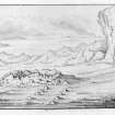
The foundation of a small oval building about 21' by 15' externally, with an entrance on the S.
The name on the OS 1st edition 6" map means "House of the Culdees" but Skene says it was known as "Cabhan Cuildeach" which means simply "the Culdee's Cell". The meaning of the name on the 2nd edition 6" is not known.
A road is supposed to have led from the Cathedral to this place. This so-called Hermit's Cell has been completely rebuilt at least once, though it may well be of Dark Ages origin (Thomas 1959).
"From the door of the house, a walk ascends to a small hillock, with the remains of a wall on each side of the walk which grows wider to the hillock. There are evident traces of the walls of the walk taking a circuit round and enclosing the hillock" (OSA 1795).
Culdees are mentioned as having been on Iona in 1164.
W F Skene 1875; Name Book 1878; C Thomas 1959; OSA 1795; D E Easson 1957; OS 6" map annotated by O G S Crawford, 1935.
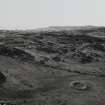
Cobhain Cuildich is as described. There is no evidence of the walk mentioned by Campbell (OSA 1795). A small enclosure, probably for stock, has been built against the rock face to the north.
Visited by OS (RD) 9 June 1972.
Field Visit (May 1979)
Cobhan Cùilteach, Iona (NM 276 249)
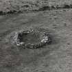
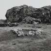
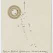
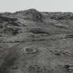
This name is now attached to the remains of a small hut, although it probably applied originally to the level area where it is situated, at the foot of Cnoc nam Bradhan and about 1 km NW of Iona Abbey. Only the stone footings of the hut survive (A on plan), and these are roughly oval on plan, measuring about 4.6m from NE to SW by 3.4m transversely within walls 0.9m in thickness. There is an entrance, probably of fairly recent origin, on the SW side, and faint traces of a track leading away to the SSE are identifiable.
About 30m N of the hut an irregular-shaped enclosure (B), measuring up to 25m by 12m internally, has been formed in the lee of a massive rock outcrop which itself serves as a wall on one side. On the remaining sides the enclosure is bounded by a wall of boulders, some of which are of considerable size; the entrance appears to have been situated on the NE side. Within the enclosure there may be seen a circular setting of stones 2m in external diameter, surrounding a reed-grown depression which may have been a well (C). Within the NW corner of the enclosure there are the remains of a rectangular building of fairly recent date (D).
A tradition had attached to this site before the end of the 18th century, when the parish minister reported ‘One place in I(ona) is still called the Culdee’s Cell. It is the foundation of a small circular house, upon a receding plain. From the door of the house a walk ascends to a small hillock. There are evident traces of the walls of the walk taking a circuit around and enclosing the hillock’ (1). The name ‘Culdee's Cell’, however, was a pseudo-learned translation, inspired by the current vogue for the Culdees, of the Gaelic name recorded in 1857 as ‘Cobhan Cuildich’, meaning ‘the remote hollow’ (2). Skene makes the plausible suggestion that this may have been the 'more remote place in the wilds' to which St Columba withdrew for prayer, and from which he could see the island of Tiree. In the absence of excavation, however, it is impossible to date the hut-circle, but the enclosure B is probably a sheep- or cattle-pen of no great antiquity.
RCAHMS 1982, visited May 1979.
(1) Stat. Acct. 14 (1795), 200
(2) Adamnan, Columba (Reeves), 421; PSAS 11 (1875-6), 337.
(3) Adomnan, Columba (Anderson), 480-3
Field Visit (April 1996 - May 1996)
Site recorded by AOC (Scotland) Ltd during an archaeological survey of the lands controlled by the National Trust for Scotland on Iona. This survey was conducted in late May and early April of 1996. The full report of this survey has been deposited with both the local SMR and the NMRS.
NM 2762 2490 Sheiling
NM 2761 2496 Enclosure and structure
Sponsor: National Trust for Scotland
T Rees 1996
Field Visit (April 1996 - May 1996)
This is a small enclosure or structure of boulder construction which now appears as a setting 1.5m broad and 0.75m high, enclosing an area, 4.6m by 3.4 m, sub-circular in plan with an opening to the south. There is a small 'alcove' in the interior, to the east of the entrance.
The boulders appear to overlie a sub-rectangular structure of similar proportions, although this may simply be the turf clad foundations of the rubble structure.
To the east is a pair of very slight parallel stone lines, running to the south-east. These stone lines run for 13.0m and are 3.0m apart at the structure and 2.5m apart at the furthest south-east point.
Cobhain Cuildich is commonly known as the ‘Hermit’s Cell' and has been attributed a twelfth century date because of a mistranslation of the Gaelic place-name as 'House of the Culdees'. An accurate translation is 'the remote hollow'. Local recollections suggest the structure is similar to circles which were used for milking cows. The stone walls running away are described as having flanked a trackway (OSA) which ran around a knoll.
(ION96 017)
Information from NTS (SCS) January 2016


