
Following the launch of trove.scot in February 2025 we are now planning the retiral of some of our webservices. Canmore will be switched off on 24th June 2025. Information about the closure can be found on the HES website: Retiral of HES web services | Historic Environment Scotland
Tormiston Mill


Lade (19th Century), Watermill (19th Century) (1884)
Site Name Tormiston Mill
Classification Lade (19th Century), Watermill (19th Century) (1884)
Alternative Name(s) Mill Of Tormiston; Stenness
Canmore ID 2150
Site Number HY31SW 60
NGR HY 31931 12553
Datum OSGB36 - NGR
Permalink http://canmore.org.uk/site/2150


- Council Orkney Islands
- Parish Stenness
- Former Region Orkney Islands Area
- Former District Orkney
- Former County Orkney
HY31SW 60.00 31931 12553
HY31SW 60.01 HY 3189 1252 Bridge
HY31SW 60.02 HY 3205 1264 Dam
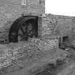
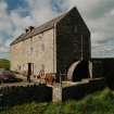
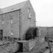
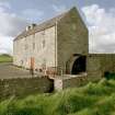
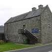
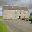
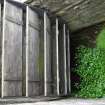
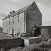
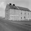
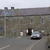
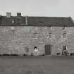
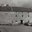
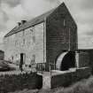
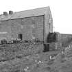
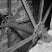
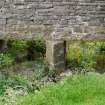
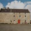
(Location cited as HY 319 125). Tormiston Mill, early to mid 19th century. A handsome three-storey rectangular range with a twin-vented kiln. The two pairs of stones were driven by an 8-spoke iron overshot wheel, 4ft (1.22m) wide by 14ft (4.27m) diameter. Now a craft shop and restaurant, with the wheel and machinery preserved. The lade is, unusually, carried on a beautifully-built stone aqueduct.
J R Hume 1977.
Publication Account (1977)
(Location cited as HY 319 125). Tormiston Mill, early to mid 19th century. A handsome three-storey rectangular range with a twin-vented kiln. The two pairs of stones were driven by an 8-spoke iron overshot wheel, 4ft (1.22m) wide by 14ft (4.27m) diameter. Now a craft shop and restaurant, with the wheel and machinery preserved. The lade is, unusually, carried on a beautifully-built stone aqueduct.
J R Hume 1977.
Publication Account (1996)
This elegant vertical-wheeled mill has been restored and adapted very successfully as a restaurant and craft shop, the use of natural wood and bare stone retaining an impression internally of the original three-storey mill. The external appearance is excellently preserved with an eightspoke iron water-wheel, more than 4m in diameter, with wooden buckets, and an unusual stone aqueduct carrying the water over the wheel. The wheel drove three pairs of millstones on the first floor, and the grain was stored in the top floor after having been dried in a kiln at the far end of the building. With the prehistoric tomb of Maes Howe across the road, this is a very attractive place to linger on a tour of Orkney's mainland monuments.
Information from ‘Exploring Scotland’s Heritage: Orkney’, (1996).
Note (30 July 2010)
Tormiston Mill is a good late example of a Scottish water powered grainn mill or the Orcadian type. It forms a visitor centre for the Maes Howe chambered cairn site and is managed by Historic Scotland.
Information from RCAHMS (MMD), 30 July 2010.
Photographic Record (30 July 2010)
Project (14 October 2014 - 23 October 2014)
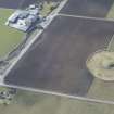
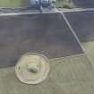
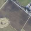
HY 31931 12553 A walkover and geophysical survey were undertaken, 14–23 October 2014, at Tormiston Mill in advance of potential development. Magnetometry and earth resistance survey were carried out in a pasture field to the E of the mill, while walkover survey was carried out both in the field and in an overgrown area to either side of Heddle Burn, adjacent to
the A965 road. A small area of GPR survey was conducted in the Tormiston Mill car park.
No extant features of archaeological significance were found in the pasture field during the walkover survey. Features recorded in the overgrown area are part of the mill complex, which is post-medieval in date.
Both the magnetometer and earth resistance surveys identified a small number of features of archaeological interest. The magnetometer data showed an area of rig and furrow cultivation across the W part of the survey area. A small cluster of curvilinear anomalies amidst the rig and
furrow may also be archaeological in origin. In the earth resistance results, an area of high resistance in the E area of the field could be archaeological in nature, but a geological origin is more likely. The GPR survey results appear to relate to modern intrusions, such as culverts or large services. An interface is visible in the data suggestive of made ground. Some areas of disturbance visible in the data below this made up ground may also be modern, but an archaeological origin cannot be ruled out.
Archive: RCAHMS (intended)
Funder: Historic Scotland
Rosalind Aitken and Thomas Desalle – ORCA
(Source: DES; OASIS ID: orkneyre1-195008)
Earth Resistance Survey (14 October 2014 - 23 October 2014)
HY 31931 12553 Resistance survey.
Archive: RCAHMS (intended)
Funder: Historic Scotland
Rosalind Aitken and Thomas Desalle – ORCA
(Source: DES; OASIS ID: orkneyre1-195008)
Magnetometry (14 October 2014 - 23 October 2014)
HY 31931 12553 Magnetometry survey.
Archive: RCAHMS (intended)
Funder: Historic Scotland
Rosalind Aitken and Thomas Desalle – ORCA
(Source: DES; OASIS ID: orkneyre1-195008)
Field Walking (22 March 2018 - 29 April 2018)
HY 31905 12680 – Tormiston Farm (Field 138), HY 31810 12385 – Tormiston Farm (Field 139), HY 32710 13020 – Lower Hobbister Farm (Field 140), HY 32400 12900 – Lower Hobbister Farm (Field 141), HY 32530 12840 – Lower Hobbister Farm (Field 142), HY 27480 14990 – Lyking Farm (Field 143), HY 27245 15030 – Lyking Farm (Field 144), HY 26990 15295 – Lyking Farm (Field 145), HY 32020 13150 – Moa Farm (Field 146), HY 26970 12820 – Seatter Farm (Field 147), HY 26960 13020 – Seatter Farm (Field 148), HY 31185 16015 – Maesquoy Farm (Field 149), HY 25725 12770 – Near Quholmslie (Field 150), HY 31060 16345 – Maesquoy Farm (Field 151), HY 30905 12105 – Tormiston Farm (Field 152), HY 27100 14975 – Lyking Farm (Field 153)
A third season of fieldwalking was undertaken, 22 March – 29 April 2018, within the Heart of Neolithic Orkney World Heritage Site Buffer Zone, West Mainland. Seventeen fields were walked with volunteers using the same methodology (10m transects). A total of 53 fields have now been walked during the project.
Prehistoric activity was evident from low density scatters and isolated worked flint (eg Fields 138, 139, 144, 146, 150 and 153) and occasional course stone tools. Three previously unrecorded prehistoric settlements were identified (likely Neolithic). In Field 138, immediately SE of Maeshowe, an area of reddish soil upon a raised area in the eastern part of the field (cHY 32010 12690) was accompanied by a stone axehead. Field 152, 200m S of the Standing Stones of Stenness, contained a low broad stony mound with reddish soil along with a perforated stone and flaked stone bar at the NW end. Field 153, contained reddish brown midden-like soil, burnt stone, flint and a single sherd of prehistoric pottery (probably Grooved Ware).
In Field 110, a stone weight was found near an area of burnt stone (re-walked, noted before), and could represent a prehistoric / early medieval settlement. Blue glass beads (Field 139), a lead ‘spoon’ object (Field 144) and a quartzite hammerstone (Field 145) were highlights. General scatters of post-medieval and modern ceramics, glass etc were recovered. The finds have yet to be analysed in full.
Archive: UHI Archaeology Institute (currently)
Funder: Orkney Archaeology Society
Daniel Lee and Christopher Gee – Archaeology Institute, UHI
(Source DES Volume 19)

