Mingulay
Building (Period Unassigned)(Possible), Chapel (19th Century), Presbytery (19th Century), Bowl (Period Unassigned), Quern(S) (Period Unassigned)
Site Name Mingulay
Classification Building (Period Unassigned)(Possible), Chapel (19th Century), Presbytery (19th Century), Bowl (Period Unassigned), Quern(S) (Period Unassigned)
Canmore ID 21373
Site Number NL58SE 7
NGR NL 56413 83432
Datum OSGB36 - NGR
Permalink http://canmore.org.uk/site/21373
- Council Western Isles
- Parish Barra
- Former Region Western Isles Islands Area
- Former District Western Isles
- Former County Inverness-shire
Chapel House, 1898, designed and built by John MacIntyre of Barra
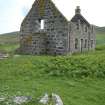
The ruin of a 'modern' gabled house with mortared masonry walls, comprising priest's house on the ground floor, with St. Columba's Chapel (reached by a forestair) above. Set above the village at a dignified distance, the house retains, even as it collapses, something of its former symbolic presence. The altar, made by the Mingulay joiner John Mackinnon, is now in the Catholic church at Castlebay (NL69NE 66). Just discernible above engulfing sand on the burn-side burial knoll, a fragment of St. Columba's Chapel, of 8th century origin (NL58SE 2).
Taken from "Western Seaboard: An Illustrated Architectural Guide", by Mary Miers, 2008. Published by the Rutland Press http://www.rias.org.uk
Desk Based Assessment (16 December 1964)
'The chapel', situated 'immediately above the bare ridge' on which lies a shell-midden (NL58SE 5), 'was erected a few years ago on the site of an older building, of which nothing remained but a shapeless heap of stones. When digging the foundations, a small stone bowl was found, and is at present in the chapel. Several boulders were also found with cavities hollowed out of the flat upper surface, These, and two basin stones got at the shell-midden, are preserved in the chapel enclosure.'
Information from OS (MSG) 16 December 1964
J Wedderspoon 1912
Field Visit (19 May 1965)
NL 5641 8341. No trace of the older building was found. The modern chapel is semi-ruinous and disused. No further information was found regarding the stone bowl.
Visited by OS (W D J) 19 May 1965
Publication Account (2000)
MY87 (NL56418343) Priest's house and chapel (modern).
Location: Valley floor.
Description: Built in 1898 in the solid modern Hebridean fashion of the late 19th and early 20th centuries, with mortared quarried stone masonry cavity walls rising to two storeys, knitted at the corners with large quoin stones. The ground floor comprises the living quarters for visiting priests, while the upper storey, reached by an external staircase on the north gable end, is a long open room that served as the chapel. The front prospect, which faces Mingulay Bay to the east, has three dormer windows to light the chapel, the central dormer gable being adorned with a small stone cross finial. The roof is covered with stone slate most likely brought from the quarries near Oban on the mainland. The building is set within its own drystone-walled square enclosure. This description is how the site appeared when I first observed it in 1991, but sadly this picutre is not true today. Bought privately in 1975, renovation and repair of the house began, but the project was not successful. The house was locked and abandoned, and began to once again deteriorate. The final years of the house were captured on film in a sad sequence that ends in total, irreparable collapse and destruction. Our first sighting in 1991 showed a hole in the rear west roofing slate. Regular storms succeeded in steadily enlarging this wound. In 1993 a ferocious storm removed many roof slates, some of which were found 300 m away. It was clear that a process of major structural damage was under way. The wind appeared to have shifted the roof tie-beam frame forwards, pushing the front facade of the house outwards in a bulge. The pressure on this bulging wall began to show at the edges, with vertical cracks that ran from top to bottom next to the quoin stones. Over the years this crack became more pronounecd and even the quoin stones themselves began to shift.
In 1994 the extent of the damage was assessed. The hole in the roof was considerably larger and the upper front southern quoin stones had fractured. Masonry was also falling from the fornt dormer window surrounds. Internally the front wall outer skin had moved forward by half a metre, while the inner skin had been held back by the upper floor joists, but these had now been pulled out of their sockets and the inner wall skin was moving outwards. In 1996 many of the upper quioins have fallen out completely and in a storm in 1997 the front elevation and the entire roof collapsed. Our last visit in 1998 still found the back wall, the gable ends with chimney stacks and most of its inner timber framing and the upper chapel floor still standing, but now open to the weather.
Branigan and Foster 2000, 103-104
Field Visit (25 June 2003)
The Roman Catholic chapel situated on an eminence to the NW of the village of Mingulay was built by 1898 (Buxton 1995, 121). The slated, quarried stone building is now ruinous, the roof and front wall having collapsed in a storm in 1997. The building (MING03 470) is a three-bay structure with a central entrance and flanking windows both front and rear, and dormers lighting the upper floor. It included accommodation for a priest on the ground floor and the chapel occupied the whole of the first floor, accessed by a stone stair to an entrance in the NE gable. The building measures 13.6m from NE to SW by 8.55m transversely over cavity stone-walls, 0.7m in thickness. The ground floor partitions, which were in an imminent state of collapse, was still standing at the date of survey and comprised a porch and lobby entered from the SE, to either side of which were two rooms, providing a dining room and kitchen on the NE and a sitting room and bedroom on the SW. The kitchen had direct access to a pantry and an external door at the rear. The building is surrounded by a drystone enclosure that is square on plan. Three saddle querns lie within the NNE quadrant of the enclosure (MING03 160, 164, 165; Branigan and Foster 2000, 95; Buxton 1981), and a quartzite tool is built into the drystone wall on the NW (MING03 371). The building is first depicted on the 2nd edition OS 6-inch map (Outer Hebrides 1901, sheet lxx). This site has been previously recorded by Branigan and Foster (2000).
MING03 160, 164, 165, 371, 470
Visited by RCAHMS (PJD) 25 June 2003.
Standing Building Recording (December 2012 - September 2013)
NL 56413 83432 A programme of archaeological work including the production of a conservation statement was carried out, December 2012 – September 2013. The chapel and presbytery on Mingulay was constructed by 1898 and dedicated to St Columba, as was its medieval predecessor (NL58SE 2). It was used irregularly until the island’s permanent population left in 1912. It was sold in 1975 and partly restored, before falling into disuse and ruination; a process that reached a climax in 1997 when the roof was blown off.
The building is important partly because of its unusual form (a chapel and presbytery within a standard 19th-century design), but also because of its connection with important individuals that featured in the history of the Western Isles of the late 19th century, including Fathers Allan Macdonald and James Chisholm, but also John Mackinnon, a key member of the Mingulay community and a skilled carpenter, who constructed the altar.
The building was surveyed at a scale of 1:100 in July 2013, and its environs were surveyed at 1:500. It is constructed of local roughly dressed stone with cast concrete margins, and details (such as chimney pots and a Belfast sink) supplied from makers in the Glasgow area. The altar from Mingulay stands in a side aisle at St Mary’s Star of the Sea, in Castlebay. A simple sundial, cut into bedrock, was noted in the chapel enclosure, as was a group of unrecorded carved stones, probably of varying age and character.
Additional time was used to complete three other measured surveys. A 1:100 survey of John Mackinnon’s House, a 1:250 survey of its environs (part of the township NL58SE 16), a 1:100 survey of the horizontal mill built by Mackinnon, and a 1:10 plan of the mill stones (NL58SE 144)
Archive: (RCAHMS). Report: NTS and RCAHMS (intended)
Funder: National Trust for Scotland
George Geddes, Alba Archaeology (Highland) Ltd, 2013
(Source: DES)


