
Mingulay


Township (Period Unassigned)
Site Name Mingulay
Classification Township (Period Unassigned)
Canmore ID 21355
Site Number NL58SE 16
NGR NL 5650 8320
NGR Description Centred on NL 5650 8320
Datum OSGB36 - NGR
Permalink http://canmore.org.uk/site/21355


First 100 images shown. See the Collections panel (below) for a link to all digital images.
- Council Western Isles
- Parish Barra
- Former Region Western Isles Islands Area
- Former District Western Isles
- Former County Inverness-shire
NL58SE 16 Centred on NL 5650 8320
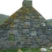
For St Columba's chapel and burial-ground, see NL58SE 2. For Crois an t-Suidheachain (NL 566 827), see NL58SE 1.
Mingulay village comprises approximately 30 buildings with associated enclosures, a chapel and a school. Only the chapel and the school-house, both semi-ruinous, are still roofed; the walls of the other buildings stand to various heights up to roof level. The village was depopulated between 1908-11.
Visited by OS May 1965, August 1973; C B Buxton 1981
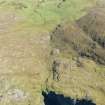
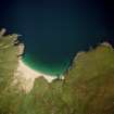
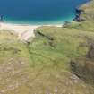
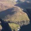
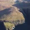
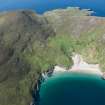
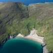
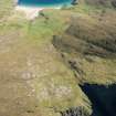
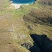
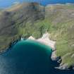
(Mingulay, village and field-system). The monument comprises the remains of the village at Mingulay Bay and its associated field system. Mingulay was abandoned in 1912 after a human occupation which lasted from at least the Bronze Age, although it first appears (by a recognisable name) in documentary sources in the mid-16th century. Since the start of written records, this has been the main settlement site on the island. The E side of the village is now becoming buried in sand up to 1.5m deep.
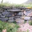
The village comprises the remains of around 50 formerly inhabited buildings, the haphazard plan indicating an organic rather than a planned growth. The present appearance is largely a product of the early 19th century, when population on the island expanded markedly. The former dwellings, which are of "southern Hebridean blackhouse" type, with rounded external angles, are relatively compact in size, and in many cases will have performed first as houses and later as barns or byres. Most survive to their modest wallhead height. A few have traces of end chimneys, but most had central hearths. Intermingled with the dwellings is an interlocking pattern of irregular enclosures, for stock management and vegetable growing, and a tortuous network of narrow pathways linking houses. To the S, outside the cluster of buildings which form the village proper and near to the well-built track which leads to the landing place at Aneir, are several further houses and associated buildings, possibly on sites later in date of first use than those in the village.
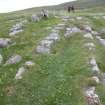
As well as the domestic buildings, which occupy repeatedly re-used sites, are several older remains. At the heart of the village is an oval burial enclosure around a low mound. This is the site of St Columba's chapel. This is certainly of pre-Reformation date but has no secure early history and shows just a few protruding coursed stones to hint at the presence of a small rectangular foundation. At the S end of the bay an ancient site called Crois an t-Suidheachan (the cross of the sitting place) survives as scattered stones: tradition holds it variously to have been a cross-site or a small religious establishment. Martin Martin (1695) records a site of worship in the form of a stone dedicated to St Christopher, which may be significant given the proximity of this site to the best landing place. Earliest of all are midden deposits which outcrop at various points around the bay and have produced pottery fragments and stone objects possibly of Iron Age date. Inland and uphill from the village are the remains of a field system enclosed by a head-dyke. This shows several generations of reorganisation in the pattern of boundaries within it.
Information from Historic Scotland, scheduling document dated 20 February 1997
Thirty-two roofed buildings, one of which is annotated as a Chapel [NL58SE 2], two partially roofed buildings, six unroofed buildings and an extensive field-system (NL562 837 to NL556 818) are depicted on the 1st edition of the OS 6-inch map (Hebrides, Barra etc, Inverness-shire 1880, sheet lxx). Three roofed, thirty-two unroofed buildings and the remains of the field-system are shown on the current edition of the OS 1:10000 map (1989).
Information from RCAHMS (SAH) 19 June 1997
The 19th-century township of Mingulay spreads along both banks of a burn that runs into Mingulay Bay and forms the focus of a field-system that occupies the lower slopes of the amphitheatre of hills. The field-system that surrounds the township (NL58SE 143). On the 1st edition OS 6-inch map the whole field-system is shown as enclosed and improved ground from Skipisdale in the S to Rudh' an Droma to the N of the bay (Outer Hebrides 1880, sheet lxx). The significant changes that were mapped at the date of the 2nd edition map (Outer Hebrides 1904, sheet lxx) include two new structures that are described elsewhere, the Roman Catholic chapel and the new school at Aneir (NL58SE 7 and NL58SE 142 respectively).
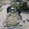
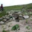
Of the forty-six buildings in the township, all but one (MING03 243) were constructed with thick walls faced inside and out by coursed rubble. Some are very dilapidated, but they all appear to be of similar construction (e.g. MING03 469, or 220). Apart from one, which has squared external corners (MING03 233), the buildings are subrectangular on plan and have rounded corners. The walls are faced with rubble and have a core of stones and sand, generally ranging from 1m to 1.6m in thickness and standing between 1m and where not visibly dilapidated a maximum of 2m in height. Many are inundated with sand and have suffered from rabbits tunnelling into the core of the walls causing collapse and subsidence. Excluding outshots and incomplete structures, the buildings range from 2.7m to 10.6m in length by between 1.9m and 4.2m in breadth internally. There are clearly a smaller and a larger type of building here. Of the former type, nine are less than 5m in length and 3m in breadth internally and they have no windows. Only one has any evidence of a fireplace, represented by an upright slab by the rear wall that might be a fireback (MING03 202). These small buildings are scattered around the settlement and complement the larger buildings, of which there are twelve. The latter have fireplaces in one or both ends. The fireplaces are mainly round-backed openings, ranging from 0.7m to 1.1m in breadth and from 0.4m to 0.55m in depth, typically with a large stone lintel. In some cases a smaller relieving lintel can be seen, often separated from the main lintel by a small opening. Several of the fireplaces still preserve a square chimney, and stone drip courses projecting from the sides indicate the line of the roof. Eleven buildings have window lights, of which some are in the end, while others one in one side, either as a pair on either side of a central entrance, or as a single window offset to one side of the entrance. Within the overall disposition of the township there are groupings of two, three and four buildings that suggest farmstead units, such as that immediately S of the burn, comprising four buildings, three enclosures and a small garden on the S (MING03 223-6), of which one at least was an outbuilding, with no evidence of a window or fireplace (MING03 224). One building has a low opening 0.6m in width in its rear wall opposite the entrance in the S (MING03 222). It may have served either as a drain from a byre or to provide a draught for a threshing floor. Drystone-walled yards are attached to many of the houses or farmstead units, and there is a narrow plot defined by a low wall in front of one building (MING03 224) that may have served as a base for a peat stack.
One building is constructed rather differently to the others. This stands on the N of the burn and is a three-bay cottage, measuring 8.9m from ENE to WSW by 3.8m within mortared rubble walls 0.55m in thickness and up to 2m in height at the gables (MING03 243). The window frames were cemented into splayed openings. In addition to the two windows either side of the entrance, there was a rear light indicating the internal division of the house into three rooms and a small light in the ENE. The mortar coping on the outer edge of the gable is grooved to suggest a slated roof.
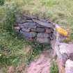
A concrete graveslab at NL5652 8318 with a central cross is set in the ground in a yard at NL 5652 8318. Two millstones liying in the grass at NL 5647 8337 (MING03 241) have probably been removed from the mill building NL58SE 144, and a quern (MING03 156) lies outside the entrance of the three-bay cottage (MING03 243).
Several spreads of midden material are visible in the vicinity of the buildings and one has previously been recorded as NL58SE 5. The most exposed is to the SE of building MING03 223, where shells, pottery, charcoal and bones are visible on the surface of the ground in what appears to be a sandy soil matrix. Other midden deposits are eroding from the yard on the NE of a building (MING03 226) on the S of the burn that flows through the village.
MING03 156, 200-227, 229-238, 241-250.
Visited by RCAHMS (PJD) 25 June 2003
Measured Survey (24 June 2003)
RCAHMS surveyed buildings 223 and 224, Village Bay Mingulay with plane-table and alidade on 24 June 2003 at a scale of 1:100. The resultant plan was redrawn in vector graphics software at a scale of 1:200.

