
Pricing Change
New pricing for orders of material from this site will come into place shortly. Charges for supply of digital images, digitisation on demand, prints and licensing will be altered.
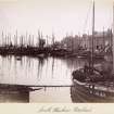
Peterhead Harbour


Harbour(S) (16th Century), Lighthouse (19th Century)
Site Name Peterhead Harbour
Classification Harbour(S) (16th Century), Lighthouse (19th Century)
Alternative Name(s) Port Henry; Keith Inch; Greenhill; Buchan Ness; Almanythie Rocks; Saltcoat Hive; Ronheads; Peterhead Bay
Canmore ID 21184
Site Number NK14NW 128
NGR NK 13771 46063
NGR Description Centred NK 13771 46063
Datum OSGB36 - NGR
Permalink http://canmore.org.uk/site/21184


- Council Aberdeenshire
- Parish Peterhead
- Former Region Grampian
- Former District Banff And Buchan
- Former County Aberdeenshire
NK14NW 128.00 centred 13771 46063
NK14NW 128.01 Centred NK 1370 4591 South Harbour
NK14NW 128.02 Centred NK 1379 4620 North Harbour
NK14NW 128.03 NK 1361 4577 to NK 1374 4576 South Pier
NK14NW 128.04 Centred NK 1364 4630 Port Henry Harbour
NK14NW 128.05 NK 1337 4634 to NK 1360 4638 Port Henry Pier
NK14NW 128.06 NK 13766 45244 to NK 13891 45608 South Harbour, North Breakwater
NK14NW 128.07 NK 13554 45171 to NK 13137 44570 South Harbour, South Breakwater
NK14NW 128.08 NK 1361 4577 South Harbour, Entrance Beacon
NK14NW 128.09 NK 1382 4787 North Harbour, Entrance Beacon
NK14NW 128.10 Centred NK 13144 45378 Harbour of Refuge (Peterhead Bay)
NK14NW 128.11 NK 1354 4516 Harbour of Refuge, South Breakwater, Beacon
NK14NW 128.12 NK 1376 4525 Harbour of Refuge, North Breakwater, Beacon
NK14NW 128.13 NK 1376 4524 to NK 1388 4561 Harbour of Refuge, North Breakwater
NK14NW 128.14 NK 1355 4517 to NK 1313 4456 Harbour of Refuge, South Breakwater
NK14NW 128.15 NK 13633 45844 Harbour Office (West Pier)
NK14NW 128.16 NK 13632 45826 West Pier, Lighthouse [Beacon]
For Peterhead Harbour, Bridge Street, Bridge, see NK14NW 142.
For Peterhead Harbour, Dry Dock, see NK14NW 147.
For Peterhead Harbour, lifeboat station and slipway, see NK14NW 153.
For A and J Buchan's Boat Yard (NK 1359 4648), see NK14NW 159.
For Customs Office (NK 1359 4592), see NK14NW 246.
For Harbour Office (NK 1363 4596), see NK14NW 249.
For Fish Market (NK 136548 45815), see NK14NW 314.
Extends onto map sheet NK14SW.
Location formerly entered as NK 137 460.
NMRS REFERENCE:
Peterhead Harbour. Architect: Thomas Telford. (1803-21).
(Undated) information in NMRS.
(Location cited as NK 137 460). Peterhead Harbour. In two parts, linked by a junction canal, which is spanned by a rolling-lift bridge built by Sir William Arrol & Co. Ltd. (1953). A complex group of basins formed by nine piers. The South Harbour was commenced in 1773 (to designs by John Smeaton), the North Harbour in 1818 (by engineer Thomas Telford), and the Middle Harbour in 1872-6. Since then, further works have been executed, notably the breakwater which was built to make Peterhead the national harbour of refuge on the E coast of Scotland from 1884. The prison (NK14NW 149) was built to supply labour for this undertaking.
J R Hume 1977.
(Location cited as NK 13 45 and 13 46). The older part of the town of Peterhead stands partly on the nose of a short, broad promontory and partly on the island of Keith Inch, which has been joined to the mainland by a causeway since about 1735. Greenhill, now likewise linked up, constitutes in fact the easternmost point of Scotland, and it may be remarked in passing that Roy's map of 1747-55 attaches the name Buchan Ness to this projection and not, as is done today, to the headland at Boddam, about two miles to the N. Coastal and North Sea shipping, particularly fishing-craft, must no doubt have frequented the sheltered channel behind Keith Inch at all periods of history, but the idea of a Viking landing-place 'among the Almanythie rocks' is insufficiently substantial to be ventilated here. A factual account of Peterhead, however, dateable on internal evidence to the 1670's and attributed to the then Countess of Erroll describes the harbour of her day as 'most commodious' and states that it 'imbosoms itself in the said Keyth Inch, and makes a Defence from the east by the Inch and numerous Rocks round about'.
The earliest positive mention of Peterhead harbour is contained in a grant made to the Earl Marischal in 1587 which covered the erection of Peterhead as a burgh of barony, and in 1593 it was followed by a contract between the Earl and the feuars of the burgh which bound the former to 'build and erect a bulwark in the mouth of ye haven, called Port Henry' and the latter to 'give personal service and concurrence to the erecting of the same bulwark, with aiken timber', and similarly to its maintenance.
More facts emerge from Lady Erroll's description: 'The harbour in it, called Port Henry, hath its name from one Henry Midleton in Clerkhill who, in the said E. George, his time (i.e. the Earl of 1593) was instrumental under the said Earl to have erected from an open shore to a secure Harbour. ...it hath on the South side a bay that is called the South Road, which will contain several hundreds of ships most securely at Anchor except when the wind bloweth from the east'. The South Road was presumably the large natural anchorage of peterhead Bay, and a further note, that it contained 'a North harbour, very secure', called Saltcoat Hive, points to some harbour-works at the S end of the Keith Inch channel.
Port Henry is further discussed by Arbuthnot, who had charge of the Peterhead harbours in the 1790's. Writing in the early 19th century, he records that there were then two harbours (North and South), known respectively as Port Henry and Sackit-hive. The basin of the former contained about three-quarters of an acre with a depth of 11ft (3.4m) at high springs; its entrance-channel was very narrow but it admitted craft of up to 100 tons. It was defended on the N by a pier of large stones, and on the E and SE by a mound and parapet recently formed with rubbish excavated from the South Harbour. Though the 'North Quay' was built of very rough material and without cement, it had, according to Arbuthnot, withstood storms undamaged for more than 200 years; but this statement appears to conflict with an earlier record of its having been almost ruined at a date which must have been very early in its life. The New Statistical Account (1840) likewise notes that it was very roughly built with masses of undressed granite, that it had never been repaired, and that the original oak timbers used as mooring-posts were still 'in a serviceable state'.
A final record of Port Henry (now destroyed in the expansion of the modern harbour) is preserved by the 1868 and 1968 editions of the OS 6-inch map. The latter marks the trace of the harbour's vanished N quadrant as lying just below the converging ends of Brook Street and Ellis Street, while the former, surveyed before the building of the present Port Henry Pier, shows it as asemi-oval enclosure among rocks, in a corresponding position and outside the then NW limit of the harbour. With this showing a plan of 1834 is in general agreement, except that it marks the basin as sub-rectangular and enclosed by piers or wharfage. There can be little doubt that the 'bulwark' of the Earl's contract survived, whether repaired or not, in the NE breakwater-pier.
Port Henry has called for this longish digression as having been a major feature of the Earl's programme of improvement, and also as throwing some light on the constructional methods of the day. But with the opening of the 18th century, the principal interest shifts to the Keith Inch channel, and to the water immediately adjoining it on the N and S.
The course of events in this area has been well described by Arbuthnot and an adequate idea of the harbour's growth can be obtained by following his lead. Thus it appears that, until about 1735, the Keith Inch channel was open, and that it was only then that it was blocked, to give land access to the island, by 'a mound composed of several thousand tons of rough material and rubbish', derived presumably from the deepening of a basin which had already existed here in 1700. Roy's map of 1747-55 shows such a basin, with what seem to be a pair of piers at the entrance, and also indicates that the block constituted a fairly wide strip of dry ground and was not simply a causeway. A basin must certainly have existed in this position for many years, as Collins (in 1682) noted two little piers, only suitable for small vessels, and Defoe 'two little piers for fishing'. In both cases, the second member of the pair of piers must presumably have been Port Henry. A process of enlargement, deepening and repairs, described in detail by Arbuthnot, went on during the 18th century, and the condition of the South harbour (as it was in 1795) is recorded in the Statistcal Account. There were then two 'excellent' piers, respectively on the S and W, which, with Keith Inch on the E, formed a basin capable of holding sixty ships. The S pier was 460 ft (140m) long, up to 42 ft (12.8m) wide and 40 ft (12.2m) high at its head; the W pier was 633 ft (193m) long and 26 ft (7.9m) high, ansd both were well built of large granite blocks. This last statement should be read in conjunction with that by Arbuthnott (1815) to the effect that, only two years earlier, the S pier had been damaged by a storm, 300 tons of 'pavement and cribs' having been thrown down into the harbour. The stones used in the building of a quay had been too small, its W end had not been founded on solid rock, and the 'hearting and packing' had also been 'very indifferent'. A point of some interest arises from the note in the Old Statistical Account, namely that the whole fishing community was concentrated in the Ronheads quarter, in the NE part of the town and conveniently close to Port Henry; this area was still used by fishermen well into the 19th century, 'Fishers town' being marked in the Ronheads area on the plan of 1834.
With the developments of the later 18th and earlier 19th centuries are associated some of the great pioneers of contemporary civil engineering. In 1771 the South Harbour was in disrepair and a new plan was obtained for it from John Smeaton, on which work started in 1773. Notwithstanding the resulting improvements, by 1807 the basin was still too small for the demands of the shipping; John Rennie was consulted and an Act of Parilament was obtained for enlarging the South Harbour and for building, in addition, a new North Harbour. In the South Harbour, accordingly, the bottom was further deepened, the W pier was lengthened, and a quay 300 ft (91m) was built on the E side, the capacity of the basin being thus increased to some 100 to 120 vessels. The new North Harbour was begun at the same time, with a protective bulwark of debris excavated from the South Harbour, but in 1815 increased accommodation was again found necessary, and works planned by Thomas Telford were carried out between 1818 and 1822; these were finished by the Stevenson firm in 1827. An additional protective pier was due for completion about 1840 on the exposed N side, and the harbour was then expected to be ready to accommodate steamers. A passage through the block in the Keith Inch channel was opened in 1849 or 1850 for communication between the N and S harbours; this had been under discussion since the days of the Statistical Account and the plan of 1834 already marks 'proposed opening'.
The financing of all these works called for a variety of expedients, beginning with the Earl Mariscal's impost of 1593. Grants and assistance of one sort or another were received from time to time from the Privy Council, the Convention of Royal Burghs, the superiors (after 1728 the Merchant mMaiden Hospital), the Commissioners for Forfeited Estates, and private sources.
A Graham 1979.
Air photographs: AAS/97/12/G25/5-7 and AAS/97/12/CT.
NMRS, MS/712/29.
Port Henry, the most ancient of Peterhead's three harbours, lay along the Seagate shore, being protected to the N by the Old Pier, which was probably erected before 1593. In due course, two more harbours were formed between the islands of Keith Inch and Greenhill, being separated into North and South [Harbours] by the 'Quinzie'. Centuries of harbour developement received the attention of some of the finest enginees to have practised in Britain: John Smeaton, John Rennie, Thomas Telford and David Stevenson.
The harbour was extended in the 1770's by the South Pier (designed by John Smeaton). In 1822, a new North Harbour (designed by Thomas Telford) was completed; the two docks were linked together in 1850. The breakwater of 1886 was built by convict labour.
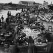
From 1778 the harbour developed a speciality in whaling, eventually becoming Britain's biggest whaling port. In 1815, before the herring explosion, there were 72 Peterhead-owned vessels operating from the port. Over 400 boats now operate from the port.
C McKean 1990.
Publication Account (2007)
Peterhead Harbour, one of Scotland’s largest and most significant in its time, is the agglomeration of three smallharbours, the North and South Harbours and Port Henry, and the much larger Harbour of Refuge to the south. The smaller harbours were constructed in the sheltered water
lying between the town of Peterhead and the offshore islands of Greenhill and Inch Keith which were joined to the shore by a causeway. The Harbour of Refuge enclosed Peterhead Bay.
Construction of the small harbours commenced in the 16th century and by the 19th century their individual identities had merged. This process was hastened when the Harbour of Refuge was constructed obviating the
need for a separate entrance to the North Harbour, which was then entered through the South Harbour. The piecemeal development of the harbours in the 18th and 19th centuries resulted in improvements from leading engineers Smeaton, Rennie, Telford, the Stevensons, Sir John Coode and Thomas Meik. In 1801 Telford foresaw ‘that a very perfect harbour could be formed at Peterhead’ and in 1806 Rennie considered Peterhead ‘a most important situation for a harbour’, opinions borne out by subsequent developments.
R Paxton and J Shipway, 2007.
Reproduced from 'Civil Engineering heritage: Scotland - Highlands and Islands' with kind permission from Thomas Telford Publishers.

