
Following the launch of trove.scot in February 2025 we are now planning the retiral of some of our webservices. Canmore will be switched off on 24th June 2025. Information about the closure can be found on the HES website: Retiral of HES web services | Historic Environment Scotland
Port Erroll, Harbour


Harbour (19th Century)
Site Name Port Erroll, Harbour
Classification Harbour (19th Century)
Alternative Name(s) Port Errol; Water Of Cruden
Canmore ID 20907
Site Number NK03NE 48
NGR NK 0941 3564
Datum OSGB36 - NGR
Permalink http://canmore.org.uk/site/20907


- Council Aberdeenshire
- Parish Cruden
- Former Region Grampian
- Former District Banff And Buchan
- Former County Aberdeenshire
NK03NE 48 0941 3564
For Port Erroll icehouse (NK 0930 3604) and salmon fishery (NK 0983 3583 and 0934 3580), see NK03NE 40 and NK03NE 49 respectively.
For anti-tank block across top of slipway (NK 0946 3566), see NK03NE 68.
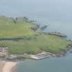
(Location cited as NK 094 356). Port Errol Harbour, late 19th century. A harbour of enclosure with two L-plan piers enclosing a basin which is subdivided by teo straight piers to form a main basin and a stilling basin; all the works are in concrete. Nearby are net-drying poles and an upturned boat used as a store in the classic manner.
J R Hume 1977.
Air photographs: AAS/94/18/G38/22-8.
NMRS, MS/712/21.
Air photograph: AAS/(A)/87/03/S3/3, flown 2 September 1987.
NMRS, MS/712/36.
Field Visit (September 2022)
NK 09410 35640 Visited during fieldwork by SCAPE. No changes to description. Drying poles still remaining but upturned boat not noted.
Information from S. Boyd and J. Hambly - Scottish Coastal Archaeology and the Problem of Erosion (SCAPE)

