
Glasgow, Anderston Quay


Quay (19th Century)
Site Name Glasgow, Anderston Quay
Classification Quay (19th Century)
Alternative Name(s) River Clyde
Canmore ID 205096
Site Number NS56SE 1469
NGR NS 5797 6493
NGR Description NS 5777 6494 to NS 5817 6492
Datum OSGB36 - NGR
Permalink http://canmore.org.uk/site/205096


- Council Glasgow, City Of
- Parish Glasgow (City Of Glasgow)
- Former Region Strathclyde
- Former District City Of Glasgow
- Former County Lanarkshire
NS56SE 1469 5797 6493 (NS 5777 6494 to NS 5817 6492)
Desk Based Assessment (16 June 2017)
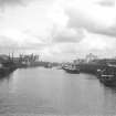
Anderston Quay is located on the N bank of the River Clyde opposite Springfield Quay and is depicted on the 1:500 OS Town Plan of Glasgow (1857, VI.10.18), at that time consisting of a series of mooring posts and two goods sheds measuring 105m by 8m and 80m by 8m respectively. The map also shows two ferry crossings to the east and west respectively of the quay and indicated by sets of steps descending to the waterline on both banks. The OS Town Plan of 1893 (Glasgow, Sheet VI.10.18) shows that the goods sheds had been replaced by one large shed measuring 218m by 16m transversely. The landing steps to the west remained, although the quayside here had been remodelled, and the east ferry crossing was annotated as the ‘Clyde Street Ferry’. During this time much work was being undertaken to deepen the Clyde and by 1871 a minimum depth of 22ft at high water was available between Greenock and the Broomielaw Quays, a distance of 22 miles. In 1867 the Kingston Dock (NS56SE 1243), immediately west of Anderston Quay on the south bank was opened, the first dock outwith the river basin. The area, now immediately west of the Kingston Bridge, has recently been landscaped. The ground on which the good shed stood is now occupied by the A814 public road and an adjoining lay-by.
Information from HES Survey and Recording (AMcC) 16 June 2017

