|
Manuscripts |
MS 712/19 |
Records of Aberdeenshire Archaeology Service, Aberdeen, Scotland
|
Photocopies of updates to Aberdeenshire Archaeological Service (formerly Grampian Regional Council) SMR, received June 1997. |
1997 |
Item Level |
|
|
Manuscripts |
MS 712/74 |
Records of Aberdeenshire Archaeology Service, Aberdeen, Scotland
|
Photocopies of Aberdeenshire Archaeological Service site record sheets for map sheet NJ80NW, received 5 March 1999. |
1999 |
Item Level |
|
|
Photographs and Off-line Digital Images |
E 94516 PO |
Records of Aberdeenshire Archaeology Service, Aberdeen, Scotland
|
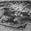
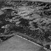
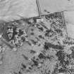
Oblique aerial view of Hill of Keir, taken from the E, centred on an enclosure and rig. |
24/1/2000 |
Item Level |
|
|
Photographs and Off-line Digital Images |
D 40068 |
RCAHMS Aerial Photography |
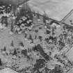
Oblique aerial view of Hill of Keir centred on the remains of an enclosure, with rig adjacent. Taken from the W. |
30/10/1998 |
Item Level |
|
|
Photographs and Off-line Digital Images |
D 40069 |
RCAHMS Aerial Photography |
Oblique aerial view of Hill of Keir centred on the remains of an enclosure, with rig adjacent. Taken from the SW. |
30/10/1998 |
Item Level |
|
|
Photographs and Off-line Digital Images |
D 40070 |
RCAHMS Aerial Photography |
Oblique aerial view of Hill of Keir centred on the remains of an enclosure, with rig adjacent. Taken from the SE. |
30/10/1998 |
Item Level |
|
|
Prints and Drawings |
DC 44348 |
Records of the Royal Commission on the Ancient and Historical Monuments of Scotland (RCAHMS), Edinbu |
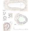
RCAHMS Plan of Hill of Keir enclosure |
26/6/2000 |
Item Level |
|
|
Prints and Drawings |
DC 44612 |
Records of the Royal Commission on the Ancient and Historical Monuments of Scotland (RCAHMS), Edinbu |
Preparatory ink drawing for scanning of 1:1250 plans of enclosures at Hill of Keir (NJ80NW 1), White Hill (NJ52SW 1) and Tillymuick (NJ62SW 3). |
2003 |
Item Level |
|
 |
On-line Digital Images |
SC 1012826 |
Records of Aberdeen Aerial Surveys, Aberdeen, Scotland |
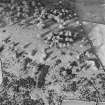
Oblique aerial view centred on the remains of the enclosure at Hill of Keir, looking to the NW. |
30/12/1980 |
Item Level |
|
 |
On-line Digital Images |
SC 1012827 |
Records of Aberdeen Aerial Surveys, Aberdeen, Scotland |
Oblique aerial view centred on the remains of the enclosure at Hill of Keir, looking to the NW. |
30/12/1980 |
Item Level |
|
|
Manuscripts |
MS 2947/1 |
Murray Archaeological Services |
Report of a walkover survey at Berryhill, Hill of Keir, Aberdeenshire. |
9/10/2003 |
Item Level |
|
|
Manuscripts |
MS 2947/2 |
Murray Archaeological Services |
Report of a watching brief at Berryhill, Hill of Keir, Aberdeenshire. |
1/11/2004 |
Item Level |
|
 |
On-line Digital Images |
SC 1333075 |
Records of the Royal Commission on the Ancient and Historical Monuments of Scotland (RCAHMS), Edinbu |
400dpi scan of DC44348 RCAHMS plan of Hill of Keir enclosure |
26/6/2000 |
Item Level |
|
 |
Digital Files (Non-image) |
WP 003405 |
Records of the Royal Commission on the Ancient and Historical Monuments of Scotland (RCAHMS), Edinbu |
Marginal Land Survey typescript site descriptions. |
1954 |
Item Level |
|
 |
On-line Digital Images |
DP 234446 |
Records of the Royal Commission on the Ancient and Historical Monuments of Scotland (RCAHMS), Edinbu |
Comparative page of forts in Donside: Hill of Newleslie; Hill of Keir; Barmkyn of North Keig; Maiden Castle; Barra Hill; Mither Tap o' Bennachie |
2007 |
Item Level |
|
 |
On-line Digital Images |
SC 1698508 |
RCAHMS Aerial Photography |
Oblique aerial view of Hill of Keir centred on the remains of an enclosure, with rig adjacent. Taken from the W. |
30/10/1998 |
Item Level |
|
 |
On-line Digital Images |
SC 1698509 |
RCAHMS Aerial Photography |
Oblique aerial view of Hill of Keir centred on the remains of an enclosure, with rig adjacent. Taken from the SW. |
30/10/1998 |
Item Level |
|
 |
On-line Digital Images |
SC 1698510 |
RCAHMS Aerial Photography |
Oblique aerial view of Hill of Keir centred on the remains of an enclosure, with rig adjacent. Taken from the SE. |
30/10/1998 |
Item Level |
|
|
Photographs and Off-line Digital Images |
SC 1937651 |
Records of Aberdeenshire Archaeology Service, Aberdeen, Scotland
|
Oblique aerial view of Hill of Keir, taken from the E, centred on an enclosure and rig. |
24/1/2000 |
Item Level |
|
 |
On-line Digital Images |
SC 2376755 |
Records of the Ordnance Survey, Southampton, Hampshire, England |
Hill Of Keir, NJ80NW 1, Ordnance Survey index card, page number 1, Recto |
c. 1958 |
Item Level |
|
 |
On-line Digital Images |
SC 2376756 |
Records of the Ordnance Survey, Southampton, Hampshire, England |
Hill Of Keir, NJ80NW 1, Ordnance Survey index card, Verso |
c. 1958 |
Item Level |
|
 |
On-line Digital Images |
SC 2376757 |
Records of the Ordnance Survey, Southampton, Hampshire, England |
Hill Of Keir, NJ80NW 1, Ordnance Survey index card, Recto |
c. 1958 |
Item Level |
|
|
All Other |
551 359/462/35 |
General Collection |
Aberdeen File |
1954 |
Sub-Group Level |
|
|
All Other |
551 166/1/1 |
Records of the Ordnance Survey, Southampton, Hampshire, England |
Archaeological site card index ('495' cards) |
1947 |
Sub-Group Level |
|


