
Following the launch of trove.scot in February 2025 we are now planning the retiral of some of our webservices. Canmore will be switched off on 24th June 2025. Information about the closure can be found on the HES website: Retiral of HES web services | Historic Environment Scotland
Hill Of Keir


Enclosure (Later Prehistoric)
Site Name Hill Of Keir
Classification Enclosure (Later Prehistoric)
Alternative Name(s) Berryhill
Canmore ID 19341
Site Number NJ80NW 1
NGR NJ 8175 0832
Datum OSGB36 - NGR
Permalink http://canmore.org.uk/site/19341


- Council Aberdeenshire
- Parish Skene
- Former Region Grampian
- Former District Gordon
- Former County Aberdeenshire
NJ80NW 1 8175 0832
(NJ 8175 0832) Fort (NR)
OS 6" map (1901)
On the Hill of Keir there is a circular broken-down wall, 170 links in diameter. It is said to have been an outpost and signal station in connection with the camp on Barmekin Hill, in Echt parish (NJ70NW 1).
Name Book 1864
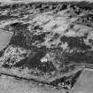
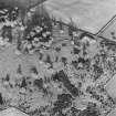
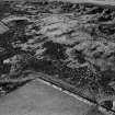
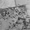
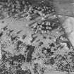
Situated on top of the hill of Keir are the mutilated remains of a stone walled enclosure c.36m in diameter. On the west side there is a considerable amount of stones and here the wall is spread to a width of c.5.0m and has a maximum height of c.0.7m The remainder of the perimeter shows only a slight amount of stones and here the wall is c1.7m wide by c.03m high. There is a possible entrance in the east side and another in the NW both c.40m wide. There is no ditch. Within the enclosure in the SW quadrant is a single ring of small loose stones c.3.2 in diameter but possibly of fairly recent origin.
Surveyed at 25" scale.
Visited by OS (WDJ) 31 October 1961.
This mutilated enclosure is situated in grassland and heather scrub at an altitude of 220m OD.
NMRS, MS/712/74.
The enclosure on the summit of the Hill of Keir is slightly oval and measures 32.5m in diameter from N to S by 29m transversely within a heavily-robbed stone wall up to 6m in thickness and 0.4m in height. Possible facing-stones are visible at a number of points on the circumference, but the course of both faces is largely masked by the spread of rubble. There is a probable entrance (4.5m wide) on the E, and a more recent break in the wall on the NW. None of the internal features noted previously were visible on the date of visit.
Visited by RCAHMS (JRS, ATW), 28 February 1997.
An archaeological walkover survey of an area N of Berryhill farm, was carried out in advance of proposals for a Telecommunications site at Berryhill. The survey concentrated on an area, c.100m square, on the S slope of the Hill of Keir. There appears to be no archaeological features on the proposed mast site.
J C & H K Murray 10th October 2003.
On the 1st November 2004, Scottish Hydro-Electric installed cable to provide an electricity supply to a recently installed telecommunications mast at Berryhill. A watching brief was maintained whilst the new supply cable was being laid. No archaeological features or finds were evident in the cable trench for the new electricity supply.
J C Murray 1st November 2004.
Scheduled as 'Berryhill, enclosure 290m N of... an oval drystone enclosure of later prehistoric date... situated at the summit of Hill of Keir at 220m above sea level.'
Information from Historic Scotland, scheduling document dated 20 February 2009.
Field Visit (25 July 1954)
This site was included within the RCAHMS Marginal Land Survey (1950-1958), an unpublished rescue project. Site descriptions, organised by county, are available to view online - see the searchable PDF in 'Digital Items'. These vary from short notes, to lengthy and full descriptions. Contemporary plane-table surveys and inked drawings, where available, can be viewed online in most cases - see 'Digital Images'. The original typescripts, notebooks and drawings can also be viewed in the RCAHMS search room.
Information from RCAHMS (GFG) 19 July 2013.
Field Visit (28 February 1997)
NJ80NW 1 8175 0832
The enclosure on the summit of the Hill of Keir is slightly oval and measures 32.5m in diameter from N to S by 29m transversely within a heavily-robbed stone wall up to 6m in thickness and 0.4m in height. Possible facing-stones are visible at a number of points on the circumference, but the course of both faces is largely masked by the spread of rubble. There is a probable entrance (4.5m wide) on the E, and a more recent break in the wall on the NW. None of the internal features noted previously were visible on the date of visit.
Visited by RCAHMS (JRS, ATW), 28 February 1997.
Measured Survey (26 June 2000)
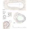
RCAHMS undertook measured survey of the enclosure at Hill of Keir in June 2000 using plane-table and self-reducing alidade. The 1:500 plan was redrawn in ink at 1:1250, enhanced in graphic vector software and published at the much reduced scale of 1:2500 (RCAHMS 2007, fig. 6.25).
Excavation (15 November 2016 - 16 November 2016)
NJ 8175 0832 (NJ80NW 1) As part of the Northern Picts project surveys and excavations have been undertaken on a number of enclosed settlements in Moray and Aberdeenshire to help construct regional datasets on the dating of fortified settlement.
An evaluation, 15–16 November 2016, targeted a univallate fort/enclosure lying on the summit of the Hill of Keir. The monument consists of a low stone wall enclosing an area c40m in diameter. Breaks in the enclosure are evident in at least four places on the northern half of the enclosure. No
previous work had been carried out at the site.
Scheduled monument consent was obtained to open a 2 x 2m trench in the interior and a 5 x 1m trench across the exterior stone wall to obtain dating evidence for the site. In the interior a possible low stone wall in the northern part of the trench and a possible floor layer was found to the
south. Radiocarbon dating of the floor layer produced a 7th–8th century AD determination. The larger trench showed extensive wall collapse from the enclosing wall on the exterior side and a possible occupation surface was found on the interior.
Archive: University of Aberdeen
Funder: University of Aberdeen and Historic Environment Scotland
Gordon Noble and Oskar Sveinbjarnarson – University of Aberdeen
Watching Brief (January 2021 - September 2021)
NJ 81749 08324 From 2017 to 2020, archaeological monitoring has been carried out for works associated with the construction of a reservoir and replacement of a water pipeline on behalf of Scottish Water. The development is located on Keir Hill, Westhill, adjacent to Berryhill Enclosure, a prehistoric Scheduled Monument (SM12334).
In June 2020, a member of the public reported to Historic Environment Scotland that a significant quantity of stone had been deposited on the monument, and that the spoil heaps resulting from the Scottish Water development works were encroaching into the Scheduled Monument area.
The stones were thought to have been taken from the nearby spoil heaps and placed on the monument by persons unknown. AOC Archaeology Group carried out an inspection of the site with a photographic recording of the interior and exterior of the monument in January and September 2021. Comparison with pre works photos from 2017 aided in identifying the areas where the monument had been recently affected, and also noting observations of modern but pre-2017 ‘additions’ to the monument. Discernible new stones were removed by hand and mechanical excavator under constant supervision in order to preserve the integrity of the site. A post-works photographic recording was then carried out. The development’s spoil heaps were also removed under archaeological supervision to ensure no further encroachment and inadvertent impact to the Scheduled Area.
Archive: NRHE
Funder: Scottish Water
Sam Williamson – AOC Archaeology Group
(Source: DES Vol 22)

