
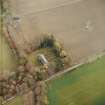
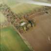
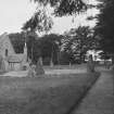
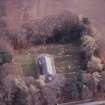
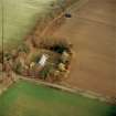
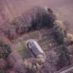
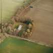
Midmar Kirk


Graffiti(S) (19th Century), Recumbent Stone Circle (Neolithic) - (Bronze Age)
Site Name Midmar Kirk
Classification Graffiti(S) (19th Century), Recumbent Stone Circle (Neolithic) - (Bronze Age)
Alternative Name(s) Midmar Church; Midmar Graveyard; Christchurch
Canmore ID 18001
Site Number NJ60NE 3
NGR NJ 69940 06493
Datum OSGB36 - NGR
Permalink http://canmore.org.uk/site/18001


- Council Aberdeenshire
- Parish Midmar
- Former Region Grampian
- Former District Gordon
- Former County Aberdeenshire
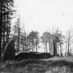
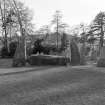
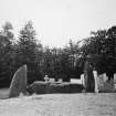
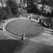
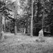
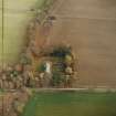
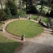
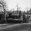
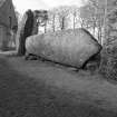
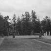
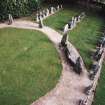
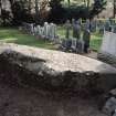
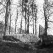
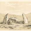
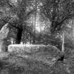
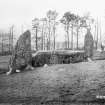
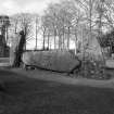
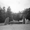
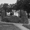
The recumbent stone circle at Midmar Kirk probably dates from the Bronze Age and consists of eight stones making up an incomplete ring measuring 17m in diameter.
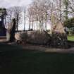
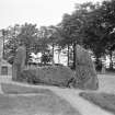
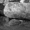
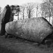
The recumbent stone on the south west side is flanked by two pillar stones, the tallest pair in the ring.
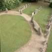
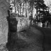
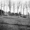
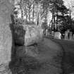
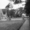
Midmar Kirk was deliberately built in close proximity to the circle, the result of an 18th century belief that the monument was a Druid religious structure - Druidism at this time was thought to be an offshoot of Christianity. It has now been incorporated into the landscaped grounds of the graveyard.
Information from RCAHMS (SC, AW) 29 August 2007
NJ60NE 3 69940 06493
(NJ 6995 0648) Stone Circle (NR)
OS 6" map, (1959)
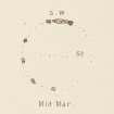
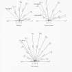
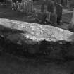
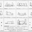
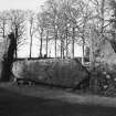
This Recumbent Stone Circle probably consisted originally of seven stones besides the flanking pillars of the recumbent stone. The latter is very broad, 4 feet (1.2m) at its widest and 14 3/4 feet (4.5m) in length. The remaining stones give a diameter to the circle of 55 feet (16.8m). Maclagan (1875) gives the diameter as 52ft (15.9m) but otherwise her plan is identical to that of Coles (1900).
F R Coles 1900; C Maclagan 1875.
A recumbent stone circle consisting of a recumbent stone, two 'flankers' and five others, with a diameter of c.17.0m. There is no trace of a central cairn, the area being utilsed as ornamental lawn.
Resurveyed at 1/2500.
Visited by OS (RL) 7 February 1968.
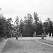
This landscaped and re-arranged recumbent stone circle (17.3m in diameter) still impresses the traveller with two splendid flankers (each 2.5m tall) which have been matched and shaped into two enormous canine teeth. The great recumbent is 4.5m long and weighs 20 tons. It is likely that at least one stone (on the NNW) has been re-erected and the ring-cairn tidied away, probably when the graveyard was laid out around the circle in 1914.
I A G Shepherd 1986.
Scheduled as Christchurch, stone circle and standing stone... the remains of a recumbent stone circle.
Information from Historic Scotland, scheduling document dated 19 November 2003.
Field Visit (July 1902)
Field Visit (1926)
Photographic Record (1930 - 1930)
Field Visit (15 July 1943)
This site was recorded as part of the RCAHMS Emergency Survey, undertaken by Angus Graham and Vere Gordon Childe during World War 2. The project archive has been catalogued during 2013-2014 and the material, which includes notebooks, manuscripts, typescripts, plans and photographs, is now available online.
Information from RCAHMS (GF Geddes) 4 December 2014.
Field Visit (7 February 1968)
A recumbent stone circle consisting of a recumbent stone, two 'flankers' and five others, with a diameter of c.17.0m. There is no trace of a central cairn, the area being utilsed as ornamental lawn.
Resurveyed at 1/2500.
Visited by OS (RL)
Photographic Record (1976)
Field Visit (1977)
Field Visit (1980 - 1981)
Reference (1986)
This landscaped and re-arranged recumbent stone circle (17.3m in diameter) still impresses the traveller with two splendid flankers (each 2.5m tall) which have been matched and shaped into two enormous canine teeth. The great recumbent is 4.5m long and weighs 20 tons. It is likely that at least one stone (on the NNW) has been re-erected and the ring-cairn tidied away, probably when the graveyard was laid out around the circle in 1914.
I A G Shepherd 1986.
Publication Account (1986)
This landscaped and re-arranged recumbent stone circle, 17.3m in diameter, still impresses the traveller with two splendid flankers, each 2.5m tall, which have been matched and shaped into two enormous canine teeth. The great recumbent is 4.5m long and weighs 20 tons. It is likely that at least one stone, on the north-north-west, has been re-erected and the ring cairn tidied away, probably when the graveyard was laid out around the circle in 1914.
Information from ‘Exploring Scotland’s Heritage: Grampian’, (1986).
Publication Account (1996)
Th is landscaped and slightly re-arranged recumbent stone circle, 17.3m in diameter, still impresses the traveller with two splendid flankers, each 2.5m tall, which have been matched and shaped into two enormous canine teeth. The great, beaked recumbent is 4.5m long and, weighs 20 tons. It is likely that at least one stone, on the north-north- west, has been re-erected and the ring cairn tidied away, probably when the graveyard was laid out around the circle in 1914.
Information from ‘Exploring Scotland’s Heritage: Aberdeen and North-East Scotland’, (1996).
Aerial Photography (1997)
Field Visit (16 April 1998)
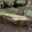
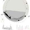
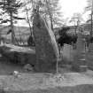
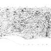
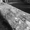
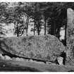
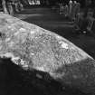
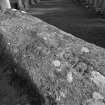
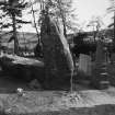
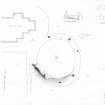
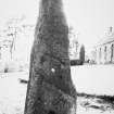
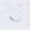
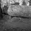
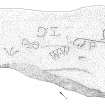
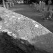
This is one of the best-known recumbent stone circles, standing encircled by a gravel path in the burial-ground beside Midmar Kirk. It is set upon the leading edge of a slight terrace facing southwards opposite the towering north flank of the Hill of Fare. Measuring 17m in diameter, the ring originally comprised about eleven stones, of which the recumbent setting and five orthostats remain, though one of the latter has been re-erected (8). The recumbent boulder (2), which measures 4.4m in length by up to 1.05m in height, is situated on the SW side of the ring and rests upon at least three support stones. Its relatively even summit has been carefully levelled, but is disfigured by graffiti; this includes some sets of initials, at least one date (1864) and several symbols akin to mason’s marks, though their large size preclude them from being genuinely medieval. Of the two flankers (1 & 3), which are 2.45m and 2.35m high respectively, the western is the more slender, but both present a similar profile to the SW, appearing to arch over the ends of the recumbent. These are the tallest stones in the ring, while the shortest of the other orthostats is on the ENE (6). The two on the southern arc of the circle (4 & 5), however, are not consistently graded in height, nor are there sufficient stones in place to determine whether the spacing of the ring closed up from S to N. In this respect the NNW orthostat (8), which has not only been repaired but also re-erected, is probably not standing in its original position. The manicured remains of a cairn form a scarp 0.3m high around the southern arc of the ring, extending about 1m outside the recumbent setting and the southernmost orthostat (4); the graded surface behind the setting suggests that a substantial body of cairn material may survive beneath the grass and gravel, though it is difficult to determine its original form and extent. If the two earthfast stones behind the W flanker and a third behind its companion on the E are kerbstones, then the setting was probably incorporated into the kerb of a cairn standing within the interior, while the scarp extending beyond the setting and the southernmost orthostat suggest the presence of on an encircling platform of cairn material.
Visited by RCAHMS (JRS, ATW, IGP and KHJM) 16 April 1998
Aerial Photography (1999)
Photographic Survey (23 April 2002)
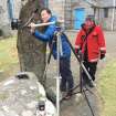
Watching Brief (11 September 2017 - 13 September 2017)
NJ 69896 06522 (NJ60NE 3) A watching brief was undertaken, 11–13 September 2017, during the excavation of trenches for a new electricity supply to Midmar Kirk, which has a recumbent stone circle within the graveyard. Trenches were excavated from the existing electric pole to the church. No archaeological features or finds were recorded.
Archive: NRHE
Funder: SSE
Alison Cameron – Cameron Archaeology
(Source: DES, Volume 18)
Field Visit (15 March 2018)
The site was visited in order to photograph in detail the graffiti carved into the upper surface of the recumbent stone. This graffiti comprises at least six sets of initials, a date of 1864, a symbol that resembles an Ordnance Survey bench mark arrow and several more that have been interpreted as either rune-like or masonic in character. On the date of visit a 3D video of the stone circle was also recorded.
Visited by HES (AGCH, ATW, ZB) 15 March 2018.

