
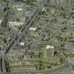
Aberdeen, Castlehill


Balcony Access Block(S) (20th Century), Slab Block(S) (20th Century)
Site Name Aberdeen, Castlehill
Classification Balcony Access Block(S) (20th Century), Slab Block(S) (20th Century)
Alternative Name(s) Aberdeen, Castlehill Section 1
Canmore ID 173563
Site Number NJ90NW 1254
NGR NJ 9463 0646
Datum OSGB36 - NGR
Permalink http://canmore.org.uk/site/173563


- Council Aberdeen, City Of
- Parish Aberdeen
- Former Region Grampian
- Former District City Of Aberdeen
- Former County Aberdeenshire
Construction (1966 - 31 December 1969)
Two slab blocks built as public housing for Aberdeen Borough Council as part of the redevelopment of Castlehill. The nineteen-storey block contains 108 dwellings. The nine-storey block contains 48 dwellings. Both blocks have balcony acccess. They are linked with walkways at several levels. The contractor for the development was W. J. Anderson Ltd. Construction began in 1966.
Glendinning and Methusius 1994
Photographic Record (April 1982)
Photo taken by Dr Miles Glendinning for research purposes.
Photographic Record (August 1982)
Photo taken by Dr Miles Glendinning for research purposes.
Photographic Record (August 1985)
Photo taken by Dr Miles Glendinning for research purposes.

