
Following the launch of trove.scot in February 2025 we are now planning the retiral of some of our webservices. Canmore will be switched off on 24th June 2025. Information about the closure can be found on the HES website: Retiral of HES web services | Historic Environment Scotland
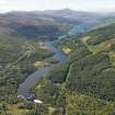
Loch Tummel, Clunie Dam


Dam (20th Century)
Site Name Loch Tummel, Clunie Dam
Classification Dam (20th Century)
Alternative Name(s) Tummel Hydro-electricity Scheme; River Tummel; Clunie Dam, Pitlochry
Canmore ID 171431
Site Number NN86SE 66
NGR NN 88432 60282
Datum OSGB36 - NGR
Permalink http://canmore.org.uk/site/171431


- Council Perth And Kinross
- Parish Dull
- Former Region Tayside
- Former District Perth And Kinross
- Former County Perthshire
NN86SE 66 88432 60282
Location formerly cited as NN 8843 6028.
Not to be confused with Port-na-Craig (Loch Faskally) dam, Pitlochry (NN 93542 57719), for which see NN95NW 62.
Clunie Dam [NAT]
OS 1:10,000 map, 1993.
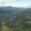
For (associated) Loch Tummel (reservoir), see also NN85NW 22.
This dam is situated at the junction of the parishes of Dull, Blair Atholl and Moulin.
Information from RCAHMS (RJCM), 20 February 2006.
Project (2007)
This project was undertaken to input site information listed in 'Civil engineering heritage: Scotland - Lowlands and Borders' by R Paxton and J Shipway, 2007.
Publication Account (2007)
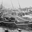
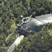
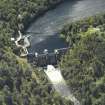
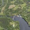
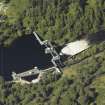
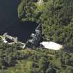
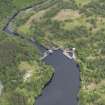
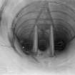
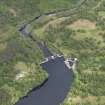
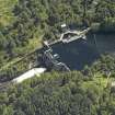
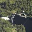
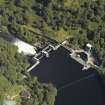
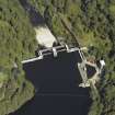
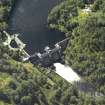
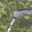
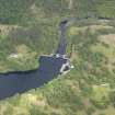
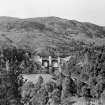
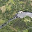
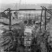
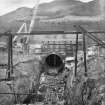
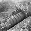
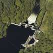
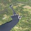
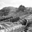
Clunie Dam is sited in the gorge of the Tummel about two miles downstream from the natural outlet of Loch Tummel. It raised the level of the loch by 17 ft and more than doubled its length. The mass gravity dam completed in 1951 is 65 ft high and has two 60 ft long automatic drum-type spillway gates for flood control which automatically lower themselves to the extent necessary to pass flood water. A fish pass with 43 pools enables salmon to surmount the dam. The main contractor was George Wimpey & Co.
R Paxton and J Shipway
Reproduced from 'Civil Engineering heritage: Scotland - Lowlands and Borders' with kind permission of Thomas Telford Publishers.
Field Visit (2010)
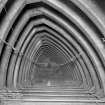
This dam controls the level of Loch Tummel providing flow regulation and storage for Clunie Power Station (see separate item). The dam fills a relatively wide gorge on the line of the ormer river bed. The dam has a large walkway oversailing two large drum gates which control the spill from the dam. A fish pass of sequential chambers is located to the southern end of the dam. Also to the south a gatehouse houses a roller gate which allows isolation of the tunnel taking water through to Clunie Power Station (see separate item). The dam is sited prominently in a gorge at the former outflow of Loch Tummel. The drum gates are unusual a response to the hydrology of this particular location, allowing floodwater to bypass the dam. The outflow from the dam is closely controlled as Pitlochry Power station is located downstream of the outfall. National Archives of Scotland (NAS), Ref: NSE North of Scotland Hydro Electric Board Collection (1943 -1990); NAS, Ref: NSE1 North of Scotland Hydro Electric Board Minutes (1943-1990); NAS, Ref NSE2 North of Scotland Hydro Electric Board Annual Reports (1943-1990); P L Payne, 1988; J Miller, 2002, 42: 88918 Scottish Hydro Electric, 2000, 18; J Gifford, 2007, 741

