
Migvie Church


Burial Ground (Early Medieval), Church (18th Century) (1777)
Site Name Migvie Church
Classification Burial Ground (Early Medieval), Church (18th Century) (1777)
Alternative Name(s) St Finan's Church; Migvie Stone; St Finnan's Church; Migvie, Old Parish Church; Migvie Churchyard
Canmore ID 16994
Site Number NJ40NW 2
NGR NJ 43668 06839
NGR Description NJ 43668 06839 and NJ 4365 0682
Datum OSGB36 - NGR
Permalink http://canmore.org.uk/site/16994


- Council Aberdeenshire
- Parish Logie-coldstone
- Former Region Grampian
- Former District Kincardine And Deeside
- Former County Aberdeenshire
NJ40NW 2.00 43668 06839 to 4365 0682
(NJ 4366 0682) Church (NR) (Site of) (NJ 4365 0682) Standing Stone (NR) (Sculptured)
OS 6" map, Aberdeenshire, 2nd ed., (1902)
NJ40NW 2.01 NJ 43670 06831 St Finan's Church
NJ40NW 2.02 NJ 43652 06822 symbol stone
NJ40NW 2.03 NJ 43670 06831 Cross incised stone
For nearby cup-marked stone (NJ 4373 0675), see NJ40NW 3.
Not to be confused with Kirk Hill, St Neachtan's Church (NJ 43235 05651), for which see NJ40NW 5.00.
The ancient church of Migvie, dedicated to St. Finan (spelt variously St. Finian, St. Finnian), was granted to the priory of St. Andrew's in the late 12th century. The Name Book (1866) records that 'part of a wall and the track of the foundations of the former church were visible in front of the present church' in 1866.
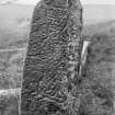
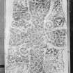
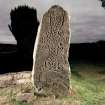
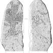
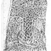
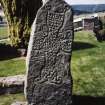
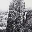
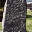
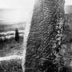
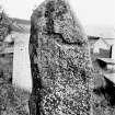
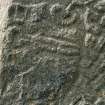
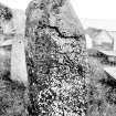
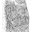
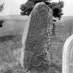
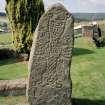
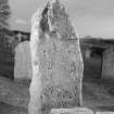
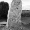
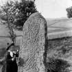
The symbol stone in the churchyard (6ft high by 2ft 5ins maximum width) is inscribed on the front with a cross and symbols, including a man on horseback. On the back of the stone is inscribed another man or horseback. Jervise notes that in 1864 the equestrian figures had recently been rechiselled and defaced. According to the Name Book (1866) the symbol stone was found 'a few feet below ground level at the spot where it now stands.'
A Jervise 1865; Name Book 1866; H Scott (Fasti Eccles Scot) 1915-61; J R Allen and J Anderson 1903; J M MacKinlay 1914; W D Simpson 1935.
(Name cited as St Finnan's Church). The churchyard is situated on a S-facing slope at an altitude of 260m OD. Newspaper reference: Press and Journal 4 October 1984.
NMRS, MS/712/44.
Field Visit (4 September 1968)
All that can be seen of the old church is a slight mound with grass-covered footings about 6.0m wide and of indefinite length.
The symbol stone is as described.
Another inscribed cross-stone lies against the S wall of the modern church. It is roughly triangular measuring 0.4m high, 0.3m wide and 0.1m thick. No further information could be obtained about it.
Surveyed at 1/2500.
Visited by OS (N K B) 4 September 1968.
Field Visit (15 August 1997)
The site of the old church is probably marked by a low grass-grown platform immediately to the S of the present building. Roughly rectangular on plan, the platform measures 10.3m from E to W by 6.8m transversely and is overlain by a slab and four headstones of 19th-century date. The Pictish cross-slab stands by the gate on the W side of the burial-ground. The inscribed stone was not located on the date of visit.
Visited by RCAHMS (ATW, SPH), 15 August 1997.

