
Pricing Change
New pricing for orders of material from this site will come into place shortly. Charges for supply of digital images, digitisation on demand, prints and licensing will be altered.
Glasgow, 68-70 Lancefield Quay, Rope Works


Rope Works (19th Century)
Site Name Glasgow, 68-70 Lancefield Quay, Rope Works
Classification Rope Works (19th Century)
Canmore ID 169723
Site Number NS56NE 2079
NGR NS 5768 6501
Datum OSGB36 - NGR
Permalink http://canmore.org.uk/site/169723


- Council Glasgow, City Of
- Parish Glasgow (City Of Glasgow)
- Former Region Strathclyde
- Former District City Of Glasgow
- Former County Lanarkshire
Desk Based Assessment (14 June 2017)
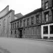
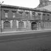
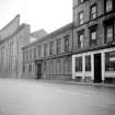
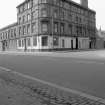
The Lancefield Quay Rope Works were located in the Anderston area of Glasgow on the north bank of the River Clyde and are depicted on the 1:500 OS Town Plan of Glasgow (1857, Sheets VI.10.13; VI.10.18). The works comprised a building facing on to Anderston Quay and a long and narrow rope walk which extended some 180m to the north. They stood adjacent to the Lancefield Foundry to the west and were originally established as an engine works in 1821 by David Napier, the marine engineer (Hume 1974; 77). It was the foundry of the Lancefield works that was later converted to the rope works that were photographed by John Hume in 1967 and 1969. They have since been demolished.
Information from HES Survey and Recording (AMcC) 14 June 2017.

