
Carron, Bridge Of Carron


Railway Bridge (19th Century), Road Bridge (20th Century)
Site Name Carron, Bridge Of Carron
Classification Railway Bridge (19th Century), Road Bridge (20th Century)
Alternative Name(s) Carron, Cast-iron Bridge; Carron Bridge; Bridge Pool; Dailuaine; River Spey
Canmore ID 16386
Site Number NJ24SW 14
NGR NJ 22451 41171
Datum OSGB36 - NGR
Permalink http://canmore.org.uk/site/16386


- Council Moray
- Parish Knockando
- Former Region Grampian
- Former District Moray
- Former County Morayshire
NJ24SW 14 22451 41171
Bridge of Carron [NAT]
OS 1:10,000 map, 1976.
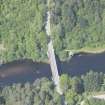
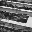
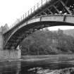
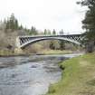
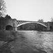
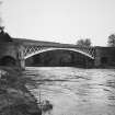
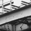
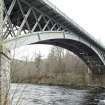
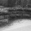
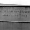
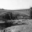
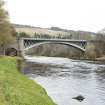
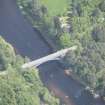
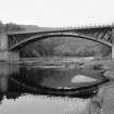
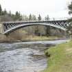
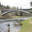
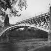
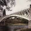
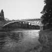
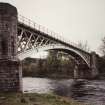
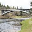
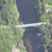
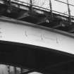
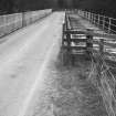
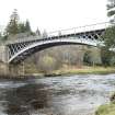
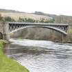
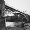
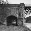
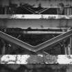
(Location cited as NJ 225 412). Cast-iron bridge, Carron. Built 1863 for the Strathspey Rly by engineers McKinnon & Co, Aberdeen. A handsome three-rib cast-iron span, flanked by segmental flood-relief and access arches. The abutments are of rustic ashlar and each rib was cast in seven parts. The bridge formerly carried a single-track railway and still carries a minor road. [The last cast-iron bridge used for railway traffic in Scotland].
J R Hume 1977.
This bridge was built by MacKinnon & Co of Aberdeen as one of three major river crossings on the Craigellachie-Nethy Bridge section of the Speyside line of the Great North of Scotland Rly, the bridge remains open to road traffic.
M Smith 1994.
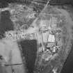
Air photographs: AAS/97/06/G12/1-4 and AAS/97/06/CT.
NMRS, MS/712/29.
This bridge formerly carried to Boat of Garten - Craigellachie ('Speyside'or 'Spey Valley') railway across the River Spey, which here forms the boundary between the parishes of Knockando (Moray) and Aberlour (Banff). It now carries road traffic.
Information from RCAHMS (RC, RJCM), 16 June 2000.
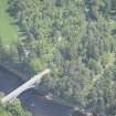
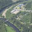
This bridge now carries an unclassified public road over the River Spey to the E of Imperial Distillery (NJ24SW 10.00). The river here forms the boundary between the parishes of Knockando (to the W) and Aberlour (to the E).
The location assigned to this record defines the midpoint of the structure. The available map evidence indicates that it extends from NJ c. 22430 41183 to NJ c. 22474 41159.
Information from RCAHMS (RJCM), 7 April 2006.
Construction (1862 - 1863)
This bridge was built in 1862–63 to carry the single-track
Strathspey Railway (Dufftown to Abernethy) and a local
road over the Spey.
R Paxton and J Shipway, 2007.
Publication Account (2007)
Carron Bridge
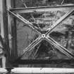
This bridge was built in 1862–63 to carry the single-track Strathspey Railway (Dufftown to Abernethy) and a local road over the Spey. It is one of Scotland’s best surviving large-span cast-iron bridges and was probably the last of its type. It consists of a central segmental arch of 150 ft span with a rise of 20 ft, flanked on each side by a 25 ft span masonry flood-relief arch.
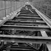
The main span has three arch ribs, each cast in seven sections and bolted together, with diagonal bracing between the ribs. The deck beams are supported on braced cruciform struts, a feature together with the curvature and span of the main arch are suggestive of a Craigellachie
Bridge influence in its design concept. Carron Bridge was designed by Alexander Gibb, engineer to the Great North of Scotland Railway, whose previous experience as a contractor had included numerous major
bridges. The ironwork was cast and erected by William McKinnon and Co., Aberdeen. Although the Strathspey line was closed in 1968 and its deck adjoining the road removed, there were proposals in 1993 for the bridge to be reconstructed in steel. This proposal was opposed by Historic Scotland, PHEW and others at a public enquiry. The bridge with its original ironwork has recently been tastefully refurbished and redecked by Aberdeenshire Council to carry the present single lane road and footways.
R Paxton and J Shipway, 2007.
Reproduced from 'Civil Engineering heritage: Scotland - Highlands and Islands' with kind permission from Thomas Telford Publishers.
Photographic Survey (2 May 2013)
Photographed on behalf of the Buildings of Scotland publications 2013-14.

