
Following the launch of trove.scot in February 2025 we are now planning the retiral of some of our webservices. Canmore will be switched off on 24th June 2025. Information about the closure can be found on the HES website: Retiral of HES web services | Historic Environment Scotland
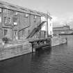
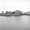
Edinburgh, Leith Docks, East Old Dock, Warehouse


Warehouse (Period Unassigned)
Site Name Edinburgh, Leith Docks, East Old Dock, Warehouse
Classification Warehouse (Period Unassigned)
Alternative Name(s) East Old Dock Entrance
Canmore ID 163413
Site Number NT27NE 57.29
NGR NT 27010 76720
Datum OSGB36 - NGR
Permalink http://canmore.org.uk/site/163413


- Council Edinburgh, City Of
- Parish Edinburgh (Edinburgh, City Of)
- Former Region Lothian
- Former District City Of Edinburgh
- Former County Midlothian
NT27NE 57.29 27010 76720
Formerly entered as NT27NE 832 at cited location NT 2701 7672.
This building was formerly situated on the N side of the entrance to the East Old Dock (NT27NE 57.33), and is depicted, but not noted on the 1970 edition of the OS 1:1250 map. It has apparently been demolished, and is not indicated on the current OS (GIS) AIB.
Information from RCAHMS (RJCM), 14 June 2006.

