
Ayr, New Bridge


Road Bridge (Period Unassigned)
Site Name Ayr, New Bridge
Classification Road Bridge (Period Unassigned)
Alternative Name(s) River Ayr
Canmore ID 158793
Site Number NS32SW 153
NGR NS 33749 22197
Datum OSGB36 - NGR
Permalink http://canmore.org.uk/site/158793


- Council South Ayrshire
- Parish Ayr
- Former Region Strathclyde
- Former District Kyle And Carrick
- Former County Ayrshire
NS32SW 153 33749 22197
For predecessor Auld Brig (Old Bridge of Ayr) situated upstream (to SE) at NS 33859 22113, see NS32SW 6.
New Bridge [NAT]
OS 1:10,000 map, 1978.
New Bridge [NAT]
OS (GIS) AIB, May 2006.
NMRS REFERENCE
Architects: Robert Adam 1785 - not executed
Alexander Stevens 1785/6
NMRS: Extracts from IC minutes & Bridge Trustees - typescript.
EXTERNAL REFERENCE
Architect: ns. nd. Plan and Elev.
Copy by W Fisher. 1885. Section.
Plans: at Darley Hay Partnership, Ayr.
(Undated) information in NMRS.
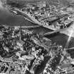
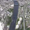
(Location cited as NS 338 222). New Bridge, built 1878-9. A 5-span bridge with dressed-sandstone arch rings, sandstone-rubble spandrels, and granite parapets. The cutwaters are rounded, and above each, on the parapet, is a cast-iron lamp standard.
J R Hume 1976.
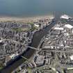
This bridge carries the A79 public road over the River Ayr within the centre of Ayr (NS32SW 208), between Main Street (to the N) and New Bridge Street (to the S). It also forms the SE limit of Ayr Harbour (NS32SW 123.00).
The location assigned to this record defines the approximate midpoint of the structure. The available map evidence indicates that it extends from NS c. 33770 22228 to NS c. 33728 22163.
Information from RCAHMS (RJCM), 19 May 2006.

