
Edinburgh, Holyrood Park, Camstone Quarry


Quarry(S) (Period Unknown)
Site Name Edinburgh, Holyrood Park, Camstone Quarry
Classification Quarry(S) (Period Unknown)
Alternative Name(s) Queen's Park; Salisbury Crags; Hunter's Bog
Canmore ID 157247
Site Number NT27SE 3943
NGR NT 2709 7330
NGR Description NT 2709 7330 to NT 2704 7354
Datum OSGB36 - NGR
Permalink http://canmore.org.uk/site/157247


- Council Edinburgh, City Of
- Parish Edinburgh (Edinburgh, City Of)
- Former Region Lothian
- Former District City Of Edinburgh
- Former County Midlothian
NT27SE 3943 2709 7330 to 2704 7354
See also NT27SE 38, NT27SE 3950, NT27SE 3952.
A cultural heritage survey of Holyrood Park, Edinburgh, was undertaken in February 1996. The survey was designed to identify and evaluate the archaeological remains present withing Holyrood Park, through the examination of desk-based sources and a field inspection. A large number of sites were already recorded within the park and are listed in the NMRS. The following list is of sites not previously recorded (excluding rig and furrow and unassociated field banks), the majority of which relate to quarrying activities or are features associated with 19th-century use and management of the park.
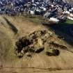
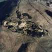
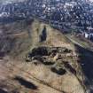
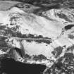
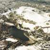
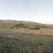
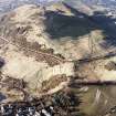
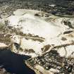
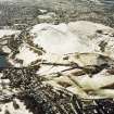
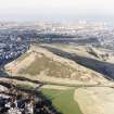
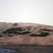
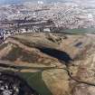
NT 270 734 Camstone Quarry.
A full report will be lodged with the NMRS.
Sponsor: Historic Scotland
D Alexander 1996
Field Visit (15 December 1998)
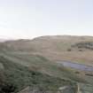
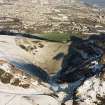
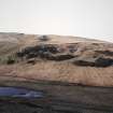
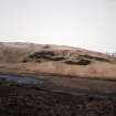
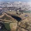
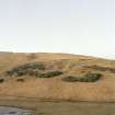
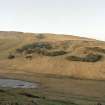
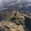
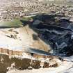
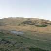
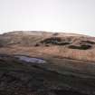
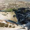
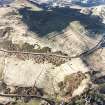
Camstone Quarry has been cut into the NE slope extending up to the lip of Salisbury Crags and overlooks Hunter's Bog. It was quarried for sandstone, and extends across an area measuring 260m from NNW to SSE by 130m transversely. The three main working faces are now largely grass-grown, and outcrop is exposed at only a few locations, while the spoil has been dumped downslope, in some instances forming sizeable mounds. The uppermost face cuts the rampart of the fort on Salisbury Crags (NT27SE 38), but is respected by the field-bank that overrides the rampart and skirts around the back. Access to the quarry was from the NE by a well-worn track that can be followed for a distance of some 170m up the slope before it splits into four immediately below the workings; the main section of the track appears wide enough to accommodate two-way traffic. The two northern branches appear to be have gone out of use first, as both are overlain by spoil dumps at their SW ends and neither is depicted on the OS 1:1056 map in 1854 (Edinburgh and its environs 1854, sheets 37). This map shows the two southern branches, but only shows the quarry as separate small-scale workings. It is unlikely, however, that the quarry had not been fully opened by this date, as the map of Holyrood Abbey Sanctuary and Environs dated to 1839 depicts Camstone Quarry more-or-less in its present form.
The maximum extent of the quarry is depicted in 1896 on the OS 25-inch map, but by this date it is annotated as 'Old Quarries' (Edinburghshire 1896, sheet iii.8). The quarry and its access routes are plotted at 1:5,550 on an archaeological map of Holyrood Park (RCAHMS 1999).
Stone for the building of Holyrood Palace between 1529 and 1536 was removed from the 'Salisbury Quarries' and transported by horse-drawn sledges to the Palace, but, given the more extensive later quarrying at both Camstone Quarry and along the Crags, it is impossible to pinpoint the position of any early workings. The small, shallow pits and hollows on the steep grassy slopes to the N of Camstone Quarry, probably represent small-scale trials or short-lived workings and, as such, may belong relatively early in the sequence. These workings are piecemeal and many are accompanied by low mounds of upcast.
Visited by RCAHMS (ARG), 15 December 1998.
NMRS, MS/726/96 (61, no. 52); RCAHMS 1999.
Watching Brief (8 November 2010 - 11 November 2010)
A watching brief was maintained during the clearance of rocks from the W face of Salisbury Crags, between the two quarry sites. Prior to any rocks being displaced, the area they would land in was inspected - as was the top of the hill, where anchor points for the ropes were to be hammered into the ground. There were no finds or features of archaeological significance.
Kirkdale Archaeology 2010 (A. Radley) OASIS ID: kirkdale1-171223
Watching Brief (8 November 2011 - 11 November 2011)
NT 270 733 (centred on) A watching brief was maintained 8–11 November 2011 during the clearance of rocks from the W face of Salisbury Crags, between the two quarry sites. Prior to the displacement of the rocks, the landing area and the area at the top of the hill, where anchor points for the ropes were placed, were examined. There were no finds or features of archaeological significance.
Archive: RCAHMS (intended)
Funder: Historic Scotland
Kirkdale Archaeology 2011
Condition Survey (13 March 2018 - 15 April 2018)
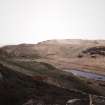
The 2018 CFA Archaeology Ltd condition survey found the site as described but with numerous pathways criss-crossing the quarry. The bank that encloses the western edge of the site looks like a modern bump stop addition probably for the grass cutting plant that work in the area above it.
Information from G. Carruthers (CFA Archaeology Ltd) July 2018. OASIS ID: cfaarcha1-317194, no. 52.

