
Rockfield, Pier


Pier (Period Unassigned)
Site Name Rockfield, Pier
Classification Pier (Period Unassigned)
Alternative Name(s) Creag Charrach; Inner Moray Firth
Canmore ID 15653
Site Number NH98SW 29
NGR NH 9245 8293
Datum OSGB36 - NGR
Permalink http://canmore.org.uk/site/15653


- Council Highland
- Parish Tarbat
- Former Region Highland
- Former District Ross And Cromarty
- Former County Ross And Cromarty
NH98SW 29 92450 82930
Jetty [NAT]
OS (GIS) MasterMap, June 2009.
Location formerly entered as NH 9245 8293.
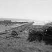
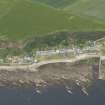
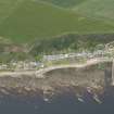
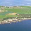
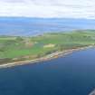
(Location cited as NH 924 829). Rockfield Pier, early 19th century. A low coursed-rubble pier. There are several small storehouses at the landward end. the nearby village has a single street of one-storey fisher houses.
J R Hume 1977.
NH 9240 8298 - Eroding shoreline away from sea defences. Pier c. 100m long and 2.5m wide. Vertical side to West, 45 degrees sloping side to East. Large squared blocks of sandstone and mortar with rings to tie up boats set into top.
Iron bars along top of pier: mounting points for boats or rails for keeping trailers on pier.
CFA/MORA Coastal Assessment Survey 1998.

