|
Photographs and Off-line Digital Images |
RC 5113 PO |
Papers of Professor John R Hume, economic and industrial historian, Glasgow, Scotland |
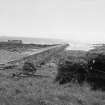
Rockfield, Pier
View from NW |
1974 |
Item Level |
|
 |
On-line Digital Images |
SC 435244 |
Papers of Professor John R Hume, economic and industrial historian, Glasgow, Scotland |
Rockfield, Pier
View from NW |
1974 |
Item Level |
|
|
Manuscripts |
MS 749/191 |
Papers of Professor John R Hume, economic and industrial historian, Glasgow, Scotland |
John R Hume Industrial/CBA cards
Filed under Ross and Cromarty, Tarbat parish. Contact print attached (Hume photo index number H74/130/8).
(see NMRS MS/749 entry for Collection description) |
14/5/1974 |
Item Level |
|
|
Manuscripts |
MS 726/167 |
Records of CFA Archaeology Ltd, archaeologists, Musselburgh, East Lothian, Scotland |
Coastal Assessment Survey: Inner Moray Firth, Volumes 1 and 2. |
14/12/1998 |
Item Level |
|
|
Manuscripts |
MS 2776/1/15 |
Historic Scotland Archive Project |
Survey archive: Site record sheets, site record sheets with field notes and monument forms from the Inner Moray Firth (Moray, Beauly and Cromarty Firth) Coastal Assessment Survey. Sheet 15. |
9/1998 |
Item Level |
|
|
Prints and Drawings |
BD 104/1/15 |
Historic Scotland Archive Project |
Survey archive: 1:25,000 OS Pathfinder map depicting site locations from the Moray, Beauly and Cromarty Firth Coastal Assessment Survey. Sheet 15. |
9/1998 |
Item Level |
|
 |
On-line Digital Images |
DP 164062 |
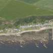
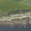
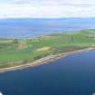
RCAHMS Aerial Photography Digital |
General oblique aerial view of Rockfield, looking WNW. |
17/7/2013 |
Item Level |
|
 |
On-line Digital Images |
DP 164063 |
RCAHMS Aerial Photography Digital |
General oblique aerial view of Rockfield, looking WNW. |
17/7/2013 |
Item Level |
|
 |
On-line Digital Images |
DP 343275 |
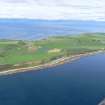
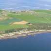
Papers of James Sloan Bone, landscape historian, Inverness, Highland, Scotland |
Aerial view of Portmahomack and Tarbat Ness, looking NW. |
18/6/2014 |
Item Level |
|
 |
On-line Digital Images |
DP 343276 |
Papers of James Sloan Bone, landscape historian, Inverness, Highland, Scotland |
Aerial view of Portmahomack and Tarbat Ness, looking NW. |
18/6/2014 |
Item Level |
|
 |
On-line Digital Images |
DP 343277 |
Papers of James Sloan Bone, landscape historian, Inverness, Highland, Scotland |
Aerial view of Portmahomack and Tarbat Ness, looking WNW. |
18/6/2014 |
Item Level |
|
 |
On-line Digital Images |
SC 2368713 |
Records of the Ordnance Survey, Southampton, Hampshire, England |
Rockfield, Pier, NH98SW 29, Ordnance Survey index card, Recto |
c. 1958 |
Item Level |
|
 |
On-line Digital Images |
SC 2368714 |
Records of the Ordnance Survey, Southampton, Hampshire, England |
Rockfield, Pier, NH98SW 29, Ordnance Survey index card, Recto |
c. 1958 |
Item Level |
|
|
Photographs and Off-line Digital Images |
BS 97/15 CS |
Historic Scotland Archive Project |
Survey photographs: From the Moray, Beauly and Cromarty Firth Coastal Assessment Survey ¿ Tarrel Burn, Meikle Tarrel, Rockfield, Ballone Castle, Bankhead, Ballone, Easter Bindal, Wilkhaven and Tarbat Ness. |
1998 |
Batch Level |
|


