 |
On-line Digital Images |
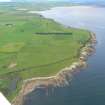
DP 343288 |
Papers of James Sloan Bone, landscape historian, Inverness, Highland, Scotland |
Aerial view of N side of Tarbat Ness near Castlehaven and towards Portmahomack, Easter Ross, looking SW. |
18/6/2014 |
Item Level |
|
 |
On-line Digital Images |
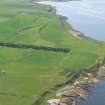
DP 343289 |
Papers of James Sloan Bone, landscape historian, Inverness, Highland, Scotland |
Aerial view of N side of Tarbat Ness near Castlehaven and towards Portmahomack, Easter Ross, looking SW. |
18/6/2014 |
Item Level |
|
 |
On-line Digital Images |
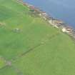
DP 343297 |
Papers of James Sloan Bone, landscape historian, Inverness, Highland, Scotland |
Aerial view of Castlehaven, N side of Tarbat Ness, Easter Ross, looking W. |
18/6/2014 |
Item Level |
|
 |
On-line Digital Images |
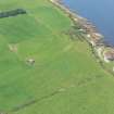
DP 343298 |
Papers of James Sloan Bone, landscape historian, Inverness, Highland, Scotland |
Aerial view of Castlehaven, N side of Tarbat Ness, Easter Ross, looking W. |
18/6/2014 |
Item Level |
|
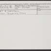 |
On-line Digital Images |
SC 2368621 |
Records of the Ordnance Survey, Southampton, Hampshire, England |
Port A' Chaistell, NH98NW 7, Ordnance Survey index card, Recto |
c. 1958 |
Item Level |
|
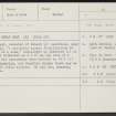 |
On-line Digital Images |
SC 2368622 |
Records of the Ordnance Survey, Southampton, Hampshire, England |
Port A' Chaistell, NH98NW 7, Ordnance Survey index card, Recto |
c. 1958 |
Item Level |
|
|
All Other |
551 166/1/1 |
Records of the Ordnance Survey, Southampton, Hampshire, England |
Archaeological site card index ('495' cards) |
1947 |
Sub-Group Level |
|


