
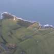
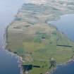
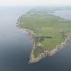
Tarbatness Lighthouse And Keepers' Cottages


Lighthouse (19th Century)
Site Name Tarbatness Lighthouse And Keepers' Cottages
Classification Lighthouse (19th Century)
Alternative Name(s) Tarbat Ness Lighthouse; Portmahomack
Canmore ID 15615
Site Number NH98NW 11
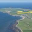
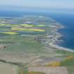
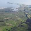
NGR NH 94695 87559
Datum OSGB36 - NGR
Permalink http://canmore.org.uk/site/15615


First 100 images shown. See the Collections panel (below) for a link to all digital images.
- Council Highland
- Parish Tarbat
- Former Region Highland
- Former District Ross And Cromarty
- Former County Ross And Cromarty
NH98NW 11.00 94695 87559
Tarbatness Lighthouse [NAT]
OS 1:10,000 map, [1977].
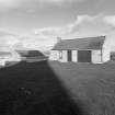
NH98NW 11.01 NH 94689 87569 East Keepers' Cottages
NH98NW 11.02 NH 94679 87559 West Keepers' Cottages
See also NH98NW 2.
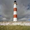
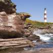
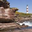
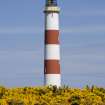
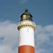
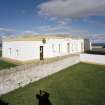
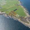
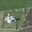
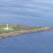
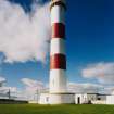
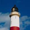
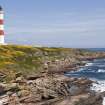
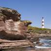
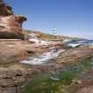
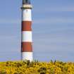
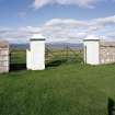
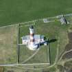
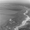
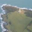
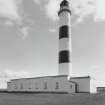
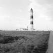
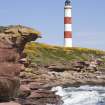
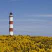
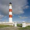
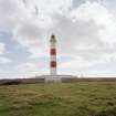
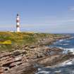
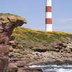
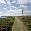
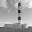
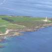
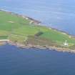
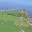
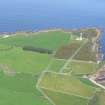
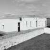
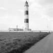
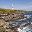
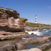
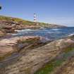
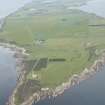
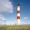
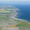
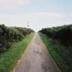
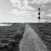
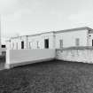
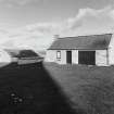
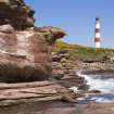
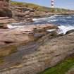
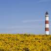
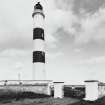
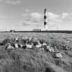
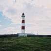
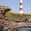
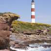
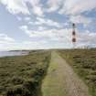
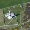
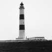
(Location cited as NH 947 876). Tarbat Ness Lighthouse, built 1830 by engineer Robert Stevenson, rebuilt 1892. A tall circular tower on a semicircular one-storey base, with a triangular paned lantern with a domed roof. The corbelled parapet is machicolated. The keepers' houses are of the normal single-storey, flat-roofed variety.
J R Hume 1977.
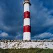
As originally built (by James Smith of Inverness) the lighthouse used obaque cylindrical shades moved in the vertical plane to display an 'intermittent' or occulting light. Eathquake shocks have been felt at the lighthouse, and the two distinguishing horizontal bands were added in 1915.
R W Munro 1979.
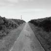
Lighthouse stable condition; helipad overgrown.
CFA/MORA Coastal Assessment Survey 1998.
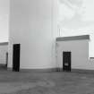
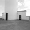
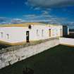
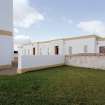
Tarbat Ness Lighthouse is was erected in 1830 by Robert Stevenson, and was rebuilt 1892. It comprises a tall circular tower on a semicircular single-storeyed base, and includes two blocks of typical Northern Lighthouse Board single-storeyed flat-roofed keepers' dwellings as well as a number of outbuildings, all of which are situated within a large compound surrounded by a random-rubble wall. The tower has a domed roof and triangular-paned lantern, beneath which there is a corbelled parapet.
At the time of survey, the light had been automated and the keepers' accommodation had been sold for private use.
Information from RCAHMS (MKO), 2003.
Photographic Survey (2003)
Tarbat Ness Lighthouse is was erected in 1830 by Robert Stevenson, and was rebuilt 1892. It comprises a tall circular tower on a semicircular single-storeyed base, and includes two blocks of typical Northern Lighthouse Board single-storeyed flat-roofed keepers' dwellings as well as a number of outbuildings, all of which are situated within a large compound surrounded by a random-rubble wall. The tower has a domed roof and triangular-paned lantern, beneath which there is a corbelled parapet. At the time of survey, the light had been automated and the Keepers' accommodation had been sold for private use.
Information from RCAHMS (MKO), 2003.

