
Glenlochar Barrage


Dam (Period Unassigned)
Site Name Glenlochar Barrage
Classification Dam (Period Unassigned)
Alternative Name(s) Galloway Hydroelectric Scheme; Loch Ken; River Dee; Water Of Ken
Canmore ID 151730
Site Number NX76SW 40
NGR NX 73196 64592
NGR Description centred
Datum OSGB36 - NGR
Permalink http://canmore.org.uk/site/151730


- Council Dumfries And Galloway
- Parish Kells
- Former Region Dumfries And Galloway
- Former District Stewartry
- Former County Kirkcudbrightshire
NX76SW 40 7322 6460
For road bridge to the S (at NX 7320 6451), see NX76SW 41.
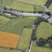
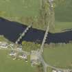
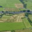
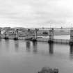
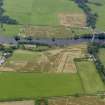
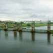
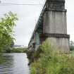
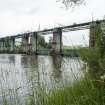
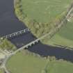
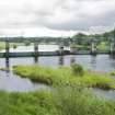
Set at the S end of Loch Ken, this barrage ('control work') regulates the outflow from the loch, raising its maximum height by 6ft (1.83m) so as to allow storage of 2000 million gallons (9.1 million cubic metres) of water within a height band of 144ft (43.9m) and 148ft (45.1m) OD. This barrage is the major regulator of the water supply to Tongland Power Station (NX65SE 86.00), the lowest in the development, as the reservoir (NX75NW 78) immediately above the power station has insufficient capacity to accommodate fluctuations of output.
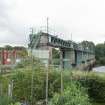
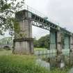
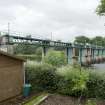
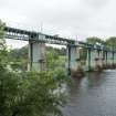
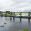
Built in about 1932, this structure is designed to provide unrestricted passage for heavy floods. Its length (measured between the inner sides of the two outermost piers) is 326ft (99.4m), and it comprises two sets of three Glenfield and Kennedy free roller sluice gates, each 45ft (13.7m) wide, separated by a fish pass opening 20ft (6.1m) wide. To suit the bed of the river, three of the gates have sills at elevation 140ft (42.68m) and are 10ft (3.05m) deep, the other three being 9ft (2.5m) and at elevation 141ft (43m); the sills are formed of steel beams embedded in concrete. Downstream from the sills, the bed of the river is protected by a lipped concrete apron and stone pitching. The fish pass is formed to two large pools within concrete walls, the passages for fish being through submerged openings in the transverse walls.
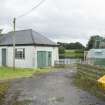
The operating machinery for the gates is mounted on the deck of a steel overbridge. They can be operated by hand, electrically from the headstocks on the bridge, or electrically from a small switch-house on the W bank. Provision is also being made for remote operation from Tongland Power Station.
The contractor was John Howard and Co. Ltd.
Anon. 1934 ['Galloway water Power Scheme'].
This barrage is remotely controlled from Tongland Power Station (NX65SE 86.00).
Anon. 1938 ['Galloway Hydro-Electric Development'].
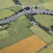
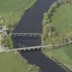
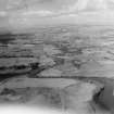
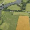
This barrage spans the River Dee (also known as the Water of Ken) at the S end of Loch Ken (NX76NW 107). The river here forms the boundary between the parishes of Balmaghie and Crossmichael. It forms a major element of Stage I of the Galloway Hydro-Electric Scheme.
Information from RCAHMS (RJCM), 29 November 2001.
Project (2007)
This project was undertaken to input site information listed in 'Civil engineering heritage: Scotland - Lowlands and Borders' by R Paxton and J Shipway, 2007.
Publication Account (2007)
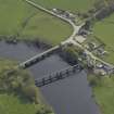
In order to increase the very limited capacity of the Loch Ken regulating reservoir, the water level of Loch Ken
was raised approximately 6 ft by the construction of a barrage of six lifting gates at Glenlochar. They are of the
fully-balanced free-roller type of 45 ft clear span, three gates being 10 ft deep and the other three 9 ft. They can
be operated either manually, by electric push-button control from the bridge, or by a remote control from the
Tongland power station. A fish pass is provided in the centre of the structure. The barrage was completed in
1934. The consulting engineers were Sir Alexander Gibb & Partners and the main contractor was John Howard & Co. Ltd. The control gates were made by Glenfield & Kennedy Ltd, Kilmarnock.
R Paxton and J Shipway 2007
Reproduced from 'Civil Engineering heritage: Scotland - Lowlands and Borders' with kind permission from Thomas Telford Publishers.
Field Visit (2010)
This barrage regulates the flow from Loch Ken before feeding it into the Dee River to feed down to Tongland Loch (see separate record). This is the main regulation for Tongland powerhouse as Tongland Loch has insufficient capacity to mediate fluctuation in flow. Flow is controlled by 3 Glenfield Roller gates and a central fish pass. Machinery to operate the gates is located on an overhead steel gantry. This is a good example of the use of a barrage as distinct from a dam. The barrage is a very precise engineering response to the particular geographic and hydrological conditions at this point on the river. A dam would not have been appropriate on this site because of the high instance of flood at this site. The barrage is a striking landscape feature and retains its original fixtures and fittings, including barrage gates and winding gear. P L Payne, 1988; E Wood, 2002; G Hill, 1984.

