
Following the launch of trove.scot in February 2025 we are now planning the retiral of some of our webservices. Canmore will be switched off on 24th June 2025. Information about the closure can be found on the HES website: Retiral of HES web services | Historic Environment Scotland
Morilemore


Field System (Period Unassigned)
Site Name Morilemore
Classification Field System (Period Unassigned)
Canmore ID 14937
Site Number NH82NW 13
NGR NH 802 283
Datum OSGB36 - NGR
Permalink http://canmore.org.uk/site/14937


- Council Highland
- Parish Moy And Dalarossie
- Former Region Highland
- Former District Inverness
- Former County Inverness-shire
NH82NW 13 802 283.
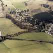
Centred at NH 801 283 in recently felled woodland is a field system marked by stone clearance heaps and an occasional lynchet. Details of cultivation plots are obscured by tree stumps.
Visited by OS (A A) 17 February 1972.
Archaeological Evaluation (March 2009)
NH 80146 28399 A programme of work was undertaken in March 2009 for a new house plot, which lies in an area of the Morilemore field system (NH82NW 13). Four clearance cairns were recorded, of which two were evaluated, though no dating evidence was recovered.
Report: HSMR and RCAHMS
Funder: Mr and Mrs Williams
Stuart Farrell

