
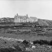
Coll, Arinagour, Arinagour Inn


Hotel (19th Century), Inn (19th Century)
Site Name Coll, Arinagour, Arinagour Inn
Classification Hotel (19th Century), Inn (19th Century)
Alternative Name(s) Arinagour Hotel, Coll Hotel
Canmore ID 145906
Site Number NM25NW 41
NGR NM 22470 57279
Datum OSGB36 - NGR
Permalink http://canmore.org.uk/site/145906


- Council Argyll And Bute
- Parish Coll
- Former Region Strathclyde
- Former District Argyll And Bute
- Former County Argyll

