
Pricing Change
New pricing for orders of material from this site will come into place shortly. Charges for supply of digital images, digitisation on demand, prints and licensing will be altered.
Castledownie


Promontory Fort (Period Unknown)
Site Name Castledownie
Classification Promontory Fort (Period Unknown)
Canmore ID 14517
Site Number NH76SE 4
NGR NH 7788 6400
Datum OSGB36 - NGR
Permalink http://canmore.org.uk/site/14517


- Council Highland
- Parish Rosemarkie
- Former Region Highland
- Former District Ross And Cromarty
- Former County Ross And Cromarty
NH76SE 4 7788 6400.
(NH 7788 6400) Castledownie (NR)
(Site of) Rampart (NR)
OS 6" map, (1959)
The site of this castle, traces of which remained in 1871, and of which nothing is known, occupies a very strong position, defended naturally on the N and E and by an earthen rampart on the S and W.
The rampart stood to a height of 4' on the outside and 3' on the inside in 1871, but when Woodham visited the site only fragmentary remains survived and the castle site was obscured by undergrowth and fallen trees.
Name Book 1871; A A Woodham 1956.
Castledownie, a heavily mutilated defensive structure overgrown with trees and bracken, is in too poor a state to classify. There is no trace of a medieval castle as suggested by the Ordnance Survey Name Book (ONB, 1871) and the pecked rectangle published on OS 6", and a more likely explanation is that it was a dun with outworks.
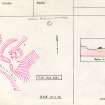
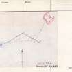
It is situated on a spur, and is protected naturally by slopes in the NW and SE, and by a shallow gully in the SW. In the NE the spur continues as a knife-edged ridge. The only artificial features surviving are two ramparts, one in the SW along the inner edge of the gully, and the other partly crossing the spur in the NE, which together with the natural slopes in the SE and the possibly partly artificially scarped slopes in the NW, enclose a sub-rectangular area measuring c. 30.0m NW-SE by 17.0m. The 1959 OS 6" map shows the SW rampart continuing along the top of the slopes in the NW but this is no longer evident. Within the enclosed area is a knoll, probably natural, which is quarried from the SW and crossed on its NE arc by the NE rampart. Several boulders, few of them earthfast, lie about the interior making no intelligible pattern. There is a gap near the centre of the SW rampart, and also at its SE extremity where it stops short of the natural slopes, either of which could be an entrance.
Resurveyed at 1:2500.
Visited by OS (A A), 12 December 1970.
This has been a desk assessment area.
J Wordsworth, SSSIs, Scottish Natural Heritage, 1993
Promontory fort - re-visited.
Ramparts if any are poughed out and natural area is a barley field. Ramparts at edges in woods eroding but not actively.
CFA/MORA Coastal Assessment Survey 1998.
Field Visit (July 1979)
Castledownie NH 778 640 NH76SE 4
This promontory earthwork is situated 800m ENE of Mains of Ethie and is formed by a single bank and ditch. The entrance lies at the centre of the arc of the bank. Dense vegetation at the date of visit obscured the interior.
RCAHMS 1979, visited July 1979
Woodham 1956, 84, no. 51.
Note (16 March 2015 - 18 May 2016)
First named and depicted on the 1st edition of the OS 25-inch map (Ross-shire 1880, sheet 79.1) with a pecked rectangular outline and an earthwork annotated Rampart, the exact character of this earthwork is uncertain, but it occupies the crest of a promontory formed where the gully of the Ethie Burn cuts through the coastal escarpment, which falls away steeply on the S to the sea some 90m below. Subsequent visits by the OS and Anthony Woodham (1955, 84) found the remains under scrub and woodland, but Keith Blood of the OS drew up a plan showing one rampart on the NE lip of a shallow gully cutting across the neck of the promontory on the SW, and a second set on the crest of the promontory some 17m to the NE; there is an entrance in the middle of the SW side, and the rampart on the NE also terminates short of the S margin of the promontory, suggesting some form of entrance. Whether these are the remains of outworks around a dun, as suggested by the OS, or whether they are the remains of defences isolating the rest of the promontory to the NE, which tails off in this direction into a narrow spine, is not known.
Information from An Atlas of Hillforts of Great Britain and Ireland – 18 May 2016. Atlas of Hillforts SC2905

