Backside Of Lipney
Corn Drying Kiln (17th Century) - (18th Century), Farmstead (17th Century) - (18th Century)
Site Name Backside Of Lipney
Classification Corn Drying Kiln (17th Century) - (18th Century), Farmstead (17th Century) - (18th Century)
Alternative Name(s) Loss Burn
Canmore ID 145032
Site Number NS89NW 72.01
NGR NS 8341 9871
Datum OSGB36 - NGR
Permalink http://canmore.org.uk/site/145032
- Council Stirling
- Parish Logie (Stirling)
- Former Region Central
- Former District Stirling
- Former County Stirlingshire
Field Visit (21 May 1997)
NS89NW 72.01 8341 9871
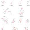
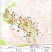
This farmstead is situated in the angle of a modern field on a broad terrace to the S of the Loss Burn. A recently fallen tree lies on the S edge of the site which is covered in rushes and nettles. The farmstead comprises three rectangular buildings (MENS97 76-8) ranged around a courtyard, with a subdivided trapezoidal enclosure on the E and a kiln (MENS97 79) to the NNE. The three buildings range from 14m to 9.4m in length by 4m and 3m in breadth within a stony bank spread to 1m in thickness and up to 0.4m in height. The building along the E side of the courtyard may have been the dwelling and there is a three compartment building along the S. The subdivided enclosure may have been a garden. A mortar lying several metres to the E of the enclosures is in use as a sheep lick.
The kiln lies some 30m to the NE of the farmstead and comprises a bowl about 2m in diameter and up to 1.2m in depth with a faced-rubble wall 1.1m in thickness. The flue is on the NNE and the bowl has been levelled into the slight slope on the S.
Backside of Lipney is documented in the 1690s and while there are records for rebuilding the house, byre and barn in 1753, there is no evidence that the farm was occupied after 1769 (Information from John Harrison).
(MENS97 76-9)
Visited by RCAHMS (DCC) 21 May 1997


