|
Manuscripts |
MS 731/19 |
Records of the Royal Commission on the Ancient and Historical Monuments of Scotland (RCAHMS), Edinbu |
Afforestable Land Survey field database (Menstrie Glen survey, 1997). Held as attribute table in GIS and in Oracle Field/AP table. Please see DX001444 |
1997 |
Item Level |
|
|
Photographs and Off-line Digital Images |
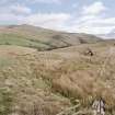
D 59301 |
Records of the Royal Commission on the Ancient and Historical Monuments of Scotland (RCAHMS), Edinbu |
View of farmstead from west. |
1998 |
Item Level |
|
|
Photographs and Off-line Digital Images |
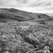
D 59302 CN |
Records of the Royal Commission on the Ancient and Historical Monuments of Scotland (RCAHMS), Edinbu |
View of farmstead from west. |
1998 |
Item Level |
|
 |
On-line Digital Images |
SC 1346654 |
Records of the Royal Commission on the Ancient and Historical Monuments of Scotland (RCAHMS), Edinbu |
Map showing distribution of settlements in Menstrie Glen before the 1760s with head-dykes and cultivated ground. Fig 11 in "Well shelterd & watered" Menstrie Glen, a farming landscape near Stirling. |
2001 |
Item Level |
|
 |
On-line Digital Images |
SC 1346666 |
Records of the Royal Commission on the Ancient and Historical Monuments of Scotland (RCAHMS), Edinbu |
Illustration showing layout of farmsteads in the Menstrie Glen. Fig 31 in "Well shelterd & watered" Menstrie Glen, a farming landscape near Stirling. |
|
Item Level |
|
 |
On-line Digital Images |
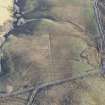
DP 175961 |
RCAHMS Aerial Photography Digital |
Oblique aerial view of the remains of the farmstead and the ploughed down field boundary and rig, looking ESE. |
7/2/2014 |
Item Level |
|
 |
On-line Digital Images |
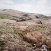
SC 1440981 |
Records of the Royal Commission on the Ancient and Historical Monuments of Scotland (RCAHMS), Edinbu |
View of farmstead from west. |
1998 |
Item Level |
|
|
Digital Files (Non-image) |
DX 001444 |
Records of the Royal Commission on the Ancient and Historical Monuments of Scotland (RCAHMS), Edinbu |
RCAHMS Structures Database - Menstrie Glen |
1997 |
Item Level |
|
|
Digital Files (Non-image) |
TM 000560 |
Records of the Royal Commission on the Ancient and Historical Monuments of Scotland (RCAHMS), Edinbu |
Zip file containing all survey linework collected during the RCAHMS Afforestable Land Survey of Menstrie Glen survey (1997). |
1997 |
Item Level |
|
 |
On-line Digital Images |
SC 2475562 |
Records of the Royal Commission on the Ancient and Historical Monuments of Scotland (RCAHMS), Edinbu |
View of farmstead from west. |
1998 |
Item Level |
|
 |
On-line Digital Images |
SC 2475563 |
Records of the Royal Commission on the Ancient and Historical Monuments of Scotland (RCAHMS), Edinbu |
View of farmstead from west. |
1998 |
Item Level |
|
|
Digital Files (Non-image) |
TM 002196 |
Records of the Royal Commission on the Ancient and Historical Monuments of Scotland (RCAHMS), Edinbu |
Zip file containing all survey linework collected during the RCAHMS Afforestable Land Survey of Menstrie Glen survey (1997). SHP and Geojson file formats with extra attribution added to the linework. |
1997 |
Item Level |
|


