
Third Inchna Burn


Farmstead (Post Medieval)
Site Name Third Inchna Burn
Classification Farmstead (Post Medieval)
Alternative Name(s) Little Jerah
Canmore ID 144988
Site Number NS89NW 54.01
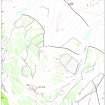
NGR NS 8466 9888
Datum OSGB36 - NGR
Permalink http://canmore.org.uk/site/144988


- Council Stirling
- Parish Logie (Stirling)
- Former Region Central
- Former District Stirling
- Former County Stirlingshire
Field Visit (22 April 1997)
NS89NW 54.01 8466 9888
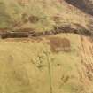
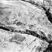
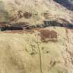
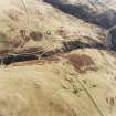
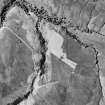
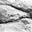
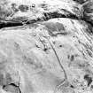
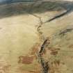
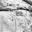
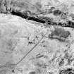
This farmstead is situated on a slight grassy terrace in broken ground on the SW-facing side of the spur between the Second and Third Inchna Burns and comprises the faced-rubble footings of three rectangular buildings, each of which has an adjacent enclosure (MENS97 18, 20, 21). A tree, recently struck by lightning, stands at the centre of the settlement. The two largest buildings (MENS97 18, 20), measuring 19.5m by 2.9m and 20.2m by 4.3m internally and with two and three compartments respectively, show evidence of phasing, originating as structures between half and two-thirds the total length. A drain in one compartment of both buildings indicates use as a byre, and a hollow outside the entrance to the N building (MENS97 18) may have been a midden. The third building (MENS97 21) comprises a single compartment measuring 9.8m by 3.8m internally with an outshot extending for 3.1m from the SSW end. The fourth structure (MENS97 19), which may be a building, is subrectangular on plan and measures 8.3m by 3.3m over a stony bank spread to 0.9m in thickness and 0.2m in height. In addition to the three enclosures adjacent to or attached to the three buildings there are two enclosures to the SE and W of the buildings.
The 1st edition of the OS 6-inch map (Perthshire and Clackmanannshire 1865-6, sheet cxxxiii; Parts of Stirlingshire 1865-6, sheets x and xi) depicts three trees at this location.
(MENS97 18-21)
Visited by RCAHMS (DCC) 22 April 1997

