|
Manuscripts |
MS 731/19 |
Records of the Royal Commission on the Ancient and Historical Monuments of Scotland (RCAHMS), Edinbu |
Afforestable Land Survey field database (Menstrie Glen survey, 1997). Held as attribute table in GIS and in Oracle Field/AP table. Please see DX001444 |
1997 |
Item Level |
|
 |
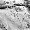
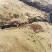
On-line Digital Images |
SC 579485 |
RCAHMS Aerial Photography |
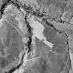
Oblique aerial view of Third and Second Inchna Burn centred on the remains of archaeological landscapes, taken from the SW. |
12/12/1997 |
Item Level |
|
 |
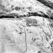
On-line Digital Images |
SC 579486 |
RCAHMS Aerial Photography |
Scan of aerial photograph D/24650/cn showing Inchney. Scanned for Menstrie Glen publication |
12/12/1997 |
Item Level |
|
|
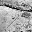
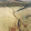
Photographs and Off-line Digital Images |
D 20770 |
RCAHMS Aerial Photography |
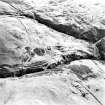
Oblique aerial view of Third and Second Inchna Burns centred on the remains of an archaeological landscape, taken from the NNW. |
12/12/1997 |
Item Level |
|
|
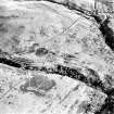
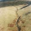
Photographs and Off-line Digital Images |
D 20771 |
RCAHMS Aerial Photography |
Oblique aerial view of Third and Second Inchna Burns centred on the remains of an archaeological landscape, taken from the NNW. |
12/12/1997 |
Item Level |
|
|
Photographs and Off-line Digital Images |
D 20772 |
RCAHMS Aerial Photography |
Oblique aerial view of Third and Second Inchna Burns centred on the remains of an archaeological landscape, taken from the NW. |
12/12/1997 |
Item Level |
|
|
Photographs and Off-line Digital Images |
D 20773 |
RCAHMS Aerial Photography |
Oblique aerial view of Third and Second Inchna Burns centred on the remains of an archaeological landscape, taken from the W. |
12/12/1997 |
Item Level |
|
|
Photographs and Off-line Digital Images |
D 20774 |
RCAHMS Aerial Photography |
Oblique aerial view of Third and Second Inchna Burns centred on the remains of an archaeological landscape, taken from the W. |
12/12/1997 |
Item Level |
|
|
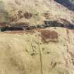
Photographs and Off-line Digital Images |
D 24649 CN |
RCAHMS Aerial Photography |
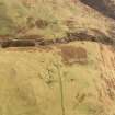
Oblique aerial view of Third and Second Inchna Burn centred on the remains of farmsteads, taken from the NW. |
12/12/1997 |
Item Level |
|
|
Photographs and Off-line Digital Images |
D 24650 CN |
RCAHMS Aerial Photography |
Oblique aerial view of Third and Second Inchna Burn centred on the remains of farmsteads, taken from the WNW. |
12/12/1997 |
Item Level |
|
|
Photographs and Off-line Digital Images |
D 24651 CN |
RCAHMS Aerial Photography |
Oblique aerial view of Third and Second Inchna Burn centred on the remains of archaeological landscapes, taken from the SW. |
12/12/1997 |
Item Level |
|
|
Photographs and Off-line Digital Images |
D 24652 CN |
RCAHMS Aerial Photography |
Oblique aerial view of Third and Second Inchna Burn centred on the remains of archaeological landscapes, taken from the SW. |
12/12/1997 |
Item Level |
|
 |
On-line Digital Images |
SC 1346654 |
Records of the Royal Commission on the Ancient and Historical Monuments of Scotland (RCAHMS), Edinbu |
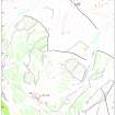
Map showing distribution of settlements in Menstrie Glen before the 1760s with head-dykes and cultivated ground. Fig 11 in "Well shelterd & watered" Menstrie Glen, a farming landscape near Stirling. |
2001 |
Item Level |
|
 |
On-line Digital Images |
SC 1346666 |
Records of the Royal Commission on the Ancient and Historical Monuments of Scotland (RCAHMS), Edinbu |
Illustration showing layout of farmsteads in the Menstrie Glen. Fig 31 in "Well shelterd & watered" Menstrie Glen, a farming landscape near Stirling. |
|
Item Level |
|
 |
On-line Digital Images |
SC 1346674 |
Records of the Royal Commission on the Ancient and Historical Monuments of Scotland (RCAHMS), Edinbu |
Map of Liittle Jerah farm. Fig 45 in "Well shelterd & watered" Menstrie Glen, a farming landscape near Stirling. |
2001 |
Item Level |
|
 |
On-line Digital Images |
SC 1727227 |
RCAHMS Aerial Photography |
Oblique aerial view of Third and Second Inchna Burns centred on the remains of an archaeological landscape, taken from the NNW. |
12/12/1997 |
Item Level |
|
 |
On-line Digital Images |
SC 1727228 |
RCAHMS Aerial Photography |
Oblique aerial view of Third and Second Inchna Burns centred on the remains of an archaeological landscape, taken from the NNW. |
12/12/1997 |
Item Level |
|
 |
On-line Digital Images |
SC 1727229 |
RCAHMS Aerial Photography |
Oblique aerial view of Third and Second Inchna Burns centred on the remains of an archaeological landscape, taken from the NW. |
12/12/1997 |
Item Level |
|
 |
On-line Digital Images |
SC 1727230 |
RCAHMS Aerial Photography |
Oblique aerial view of Third and Second Inchna Burns centred on the remains of an archaeological landscape, taken from the W. |
12/12/1997 |
Item Level |
|
 |
On-line Digital Images |
SC 1727231 |
RCAHMS Aerial Photography |
Oblique aerial view of Third and Second Inchna Burns centred on the remains of an archaeological landscape, taken from the W. |
12/12/1997 |
Item Level |
|
 |
On-line Digital Images |
SC 1727257 |
RCAHMS Aerial Photography |
Oblique aerial view of Third and Second Inchna Burn centred on the remains of farmsteads, taken from the NW. |
12/12/1997 |
Item Level |
|
 |
On-line Digital Images |
SC 1727258 |
RCAHMS Aerial Photography |
Oblique aerial view of Third and Second Inchna Burn centred on the remains of farmsteads, taken from the WNW. |
12/12/1997 |
Item Level |
|
 |
On-line Digital Images |
SC 1727259 |
RCAHMS Aerial Photography |
Oblique aerial view of Third and Second Inchna Burn centred on the remains of archaeological landscapes, taken from the SW. |
12/12/1997 |
Item Level |
|
 |
On-line Digital Images |
SC 1727260 |
RCAHMS Aerial Photography |
Oblique aerial view of Third and Second Inchna Burn centred on the remains of archaeological landscapes, taken from the SW. |
12/12/1997 |
Item Level |
|


