|
Manuscripts |
MS 731/19 |
Records of the Royal Commission on the Ancient and Historical Monuments of Scotland (RCAHMS), Edinbu |
Afforestable Land Survey field database (Menstrie Glen survey, 1997). Held as attribute table in GIS and in Oracle Field/AP table. Please see DX001444 |
1997 |
Item Level |
|
|
Photographs and Off-line Digital Images |
D 20775 |
RCAHMS Aerial Photography |
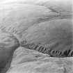
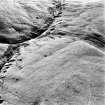
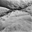
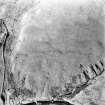
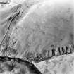
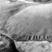
Oblique aerial photograph of shieling-huts and bank on west bank of the Second Inchna Burn (NS89NE 109) with head-dyke of neighbouring field-system (NS89NW 54.02) in background, from north-east. |
12/12/1997 |
Item Level |
|
|
Photographs and Off-line Digital Images |
D 20776 |
RCAHMS Aerial Photography |
Oblique aerial photograph of shieling-huts and bank on west bank of the Second Inchna Burn (NS89NE 109) with head-dyke of neighbouring field-systems (NS89NW 54.02 and NS89NE 56.03) in background, from north-east. |
12/12/1997 |
Item Level |
|
|
Photographs and Off-line Digital Images |
D 20777 |
RCAHMS Aerial Photography |
Oblique aerial photograph of shieling-huts and bank on west bank of the Second Inchna Burn (NS89NE 109) with head-dyke of neighbouring field-systems (NS89NW 54.02 and NS89NE 56.03) in background, from north. |
12/12/1997 |
Item Level |
|
|
Photographs and Off-line Digital Images |
D 20778 |
RCAHMS Aerial Photography |
Oblique aerial photograph of shieling-huts and bank on west bank of the Second Inchna Burn (NS89NE 109) with head-dyke of neighbouring field-system (NS89NW 54.02) in background, from east. |
12/12/1997 |
Item Level |
|
|
Photographs and Off-line Digital Images |
D 20779 |
RCAHMS Aerial Photography |
Oblique aerial photograph of shieling-huts and bank on west bank of the Second Inchna Burn (NS89NE 109) with head-dyke of neighbouring field-system (NS89NW 54.02) in background, from east. |
12/12/1997 |
Item Level |
|
|
Photographs and Off-line Digital Images |
D 20780 |
RCAHMS Aerial Photography |
Oblique aerial photograph of shieling-huts and bank on west bank of the Second Inchna Burn (NS89NE 109) with head-dyke of neighbouring field-system (NS89NW 54.02) in background, taken from the ENE. |
12/12/1997 |
Item Level |
|
 |
On-line Digital Images |
SC 1346674 |
Records of the Royal Commission on the Ancient and Historical Monuments of Scotland (RCAHMS), Edinbu |
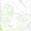
Map of Liittle Jerah farm. Fig 45 in "Well shelterd & watered" Menstrie Glen, a farming landscape near Stirling. |
2001 |
Item Level |
|
 |
On-line Digital Images |
SC 1727232 |
RCAHMS Aerial Photography |
Oblique aerial photograph of shieling-huts and bank on west bank of the Second Inchna Burn (NS89NE 109) with head-dyke of neighbouring field-system (NS89NW 54.02) in background, from north-east. |
12/12/1997 |
Item Level |
|
 |
On-line Digital Images |
SC 1727233 |
RCAHMS Aerial Photography |
Oblique aerial photograph of shieling-huts and bank on west bank of the Second Inchna Burn (NS89NE 109) with head-dyke of neighbouring field-systems (NS89NW 54.02 and NS89NE 56.03) in background, from north-east. |
12/12/1997 |
Item Level |
|
 |
On-line Digital Images |
SC 1727234 |
RCAHMS Aerial Photography |
Oblique aerial photograph of shieling-huts and bank on west bank of the Second Inchna Burn (NS89NE 109) with head-dyke of neighbouring field-systems (NS89NW 54.02 and NS89NE 56.03) in background, from north. |
12/12/1997 |
Item Level |
|
 |
On-line Digital Images |
SC 1727235 |
RCAHMS Aerial Photography |
Oblique aerial photograph of shieling-huts and bank on west bank of the Second Inchna Burn (NS89NE 109) with head-dyke of neighbouring field-system (NS89NW 54.02) in background, from east. |
12/12/1997 |
Item Level |
|
 |
On-line Digital Images |
SC 1727236 |
RCAHMS Aerial Photography |
Oblique aerial photograph of shieling-huts and bank on west bank of the Second Inchna Burn (NS89NE 109) with head-dyke of neighbouring field-system (NS89NW 54.02) in background, from east. |
12/12/1997 |
Item Level |
|
 |
On-line Digital Images |
SC 1727237 |
RCAHMS Aerial Photography |
Oblique aerial photograph of shieling-huts and bank on west bank of the Second Inchna Burn (NS89NE 109) with head-dyke of neighbouring field-system (NS89NW 54.02) in background, taken from the ENE. |
12/12/1997 |
Item Level |
|
|
Digital Files (Non-image) |
DX 001444 |
Records of the Royal Commission on the Ancient and Historical Monuments of Scotland (RCAHMS), Edinbu |
RCAHMS Structures Database - Menstrie Glen |
1997 |
Item Level |
|
|
Digital Files (Non-image) |
TM 000560 |
Records of the Royal Commission on the Ancient and Historical Monuments of Scotland (RCAHMS), Edinbu |
Zip file containing all survey linework collected during the RCAHMS Afforestable Land Survey of Menstrie Glen survey (1997). |
1997 |
Item Level |
|
|
Digital Files (Non-image) |
TM 002196 |
Records of the Royal Commission on the Ancient and Historical Monuments of Scotland (RCAHMS), Edinbu |
Zip file containing all survey linework collected during the RCAHMS Afforestable Land Survey of Menstrie Glen survey (1997). SHP and Geojson file formats with extra attribution added to the linework. |
1997 |
Item Level |
|


