
Second Inchna Burn


Bank (Earthwork) (Medieval) - (Post Medieval), Shieling Hut(S) (Medieval) - (Post Medieval)
Site Name Second Inchna Burn
Classification Bank (Earthwork) (Medieval) - (Post Medieval), Shieling Hut(S) (Medieval) - (Post Medieval)
Canmore ID 144307
Site Number NS89NE 109
NGR NS 8519 9958
Datum OSGB36 - NGR
Permalink http://canmore.org.uk/site/144307


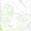
- Council Stirling
- Parish Logie (Stirling)
- Former Region Central
- Former District Stirling
- Former County Stirlingshire
Field Visit (4 June 1997)
NS89NE 109 8519 9958
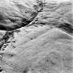
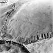
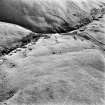
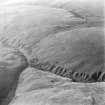
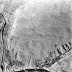
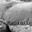
A group of nine shieling-huts are ranged along a grassy terrace on the NW side of the valley of the Second Inchna Burn, some 100m beyond the head-dyke which runs between the Second and Third Inchna Burns. The huts are all subrectangular on plan and lie across the terrace, aligned from NW to SE or from NNW to SSE. The huts measure from 5.2m to 11.7m in length by up to 3.3m in breadth within turf walls spread up to 1.2m in thickness and standing up to 0.3m in height. Five of the huts (MENS97 129, 131-4) are divided into two compartments and entrances are visible in the side walls of just two (MENS97 127, 131).
(MENS97 126-34)
Visited by RCAHMS (DCC) 4 June 1997
Aerial Photographic Interpretation (2 October 2001)
Examination of oblique aerial photography (RCAHMSAP 1997) has revealed a slight turf bank extending along the contour to the NW of the shieling-huts. To the E it turns down towards the Second Inchna Burn, effectively enclosing the terrace on which the huts are situated.
Information from RCAHMS (DCC) 2 October 2001

