
Following the launch of trove.scot in February 2025 we are now planning the retiral of some of our webservices. Canmore will be switched off on 24th June 2025. Information about the closure can be found on the HES website: Retiral of HES web services | Historic Environment Scotland
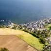
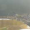
Avoch, Harbour


Harbour (19th Century)
Site Name Avoch, Harbour
Classification Harbour (19th Century)
Alternative Name(s) Avoch Harbour; Inner Moray Firth; Fortrose Bay
Canmore ID 14401
Site Number NH75NW 72
NGR NH 70429 55073
NGR Description Centred NH 70429 55073
Datum OSGB36 - NGR
Permalink http://canmore.org.uk/site/14401


- Council Highland
- Parish Avoch
- Former Region Highland
- Former District Ross And Cromarty
- Former County Ross And Cromarty
NH75NW 72.00 centred 70429 55073
NH75NW 72.01 NH 70567 55062 Beacon (South Pier)
For warehouse at NH 70402 55107, see NH75NW 71.
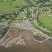
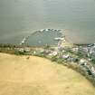
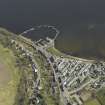
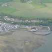
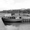
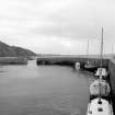
(Location cited as NH 705 550). Avoch Harbour, originally built 1813-15, engineer Thomas Telford. An irregular basin formed by a C-plan pier, mainly concrete, and an older straight pier. A small concrete pier with wood-piled faces juts out into the basin. Facing the harbour is a 2-storey, 7-bay warehouse [NH75NW 71], probably 18th century, reconstructed as a ship-chandler's store.
J R Hume 1977.
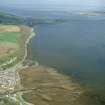
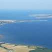
(Location cited as NH 705 551). Avoch: in 1795 good anchorage was noted between Seatown of Avoch [location not etablished] and Castletown Point [Castleton: NH 693 537], and except in southerly or south-easterly gales craft could lie safely and work cargoes on Seatown beach. A pier was built in 1814. The OS 1:2500 map of 1873 shows a 30yd (27.4m) long quay, from the W end of which a pier projects just over 56yds [51.2m] at right angles, ending in a return head parallel with the shore quay, also 30yds (27.4m) long. These measurements correspond with those of the harbour at Avoch which T Telford is recorded as having built between 1813 and 1815.
Structure
The modern road (A832) from Inverness to Fortrose is separated from the head of Avoch harbour only by a sea wall. The damaged footage of this wall is of red stone block construction, like that of the inside face of the pier to the W. There are flights of steps inset in this face near each end. Part of the face, towards the sea end, is built of smaller dark red blocks, neatly coursed and much worn. The whole face slightly battered, and is in much better repair than the sea wall, though broken at the corner where the two once joined at an oblique angle. The debris here may be that of a former slipway. Modern extensions have replaced or obscured the rest of Telford's harbour.
A Graham and J Gordon 1988.
A Gibb 1935.
Harbour; architect, Telford - visited.
19th century AD; 1803-21.
(This site number is listed on the monument and coastal erosion form, but the form is actually describing NH75NW 65)
CFA/MORA Coastal Assessment Survey 1998.
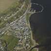
This harbour projects into Fortrose Bay to the E of the village NH75NW 94.
Information from RCAHMS (RJCM), 3 May 2005.
Publication Account (2007)
Avoch (NH75NW 72.0, 1815), Fortrose Harbour (NH75NW 65.0, 1817) and Portmahomack Harbour (NH98SW 28, 1816), in vicinity of each other, all similar and built under supervision of Thomas Telford.
R Paxton and J Shipway, 2007

