
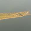
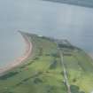
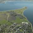
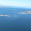
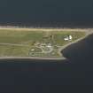
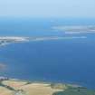
Chanonry Point, Lighthouse


Gate Pier(S) (19th Century), Lighthouse (19th Century), Wall (19th Century)
Site Name Chanonry Point, Lighthouse
Classification Gate Pier(S) (19th Century), Lighthouse (19th Century), Wall (19th Century)
Alternative Name(s) Chanonry Ness; Chanonry Lighthouse
Canmore ID 14399
Site Number NH75NW 70
NGR NH 74944 55704
Datum OSGB36 - NGR
Permalink http://canmore.org.uk/site/14399


- Council Highland
- Parish Rosemarkie
- Former Region Highland
- Former District Ross And Cromarty
- Former County Ross And Cromarty
NH75NW 70.00 74944 55704
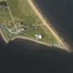
NH75NW 70.01 NH 74929 55708 20, Lighthouse Keeper's Cottage
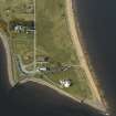
For nearby Ferry Pier (NH 74876 55638) and icehouse (NH 74716 55744), see NH75NW 52 and NH75NW 55 respectively.
Chanonry Lighthouse (occulting white) [NAT]
OS (GIS) AIB, April 2006.
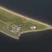
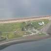
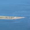
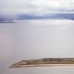
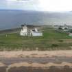
(Location cited as NH 749 558). Chanonry Lighthouse, built 1846, engineer Alan Stevenson. A typical lighthouse of the area, with a short circular tower on a semi-circular single-storey base and a circular triangular-paned lantern with a domed top. The single-storey keepers' houses are Egyptian in style.
J R Hume 1977.
Chanonry: major automatic light. Lit 1846; automated 1984.
Position: N57 34.5 W4 5.4.
Characteristics: occulting white every 6 seconds; nominal range 15 miles.
White tower, 13m high, of architectural and historical interest.
K Allardyce and E M Hood 1986.
Lighthouse - visited.
19th century.
CFA/MORA Coastal Assessment Survey 1998.
Photographic Survey (July 1961)
Photographs of buildings at Chanonry Point, Ross and Cromarty, by the Scottish National Buildings Record in 1961.
Publication Account (2007)
Chanonry Point Lighthouse
(Institute Civil Engineers Historic Engineering Works no. HEW 2546)
This lighthouse was built in 1846 adjacent to the pier for the ferry across the Moray Firth from Fort George at a cost, including the light-keepers dwellings, of £3570. Its tower is 43 ft high and similar in appearance to nearby Cromarty Lighthouse. Both lighthouses were designed with revolving lights by Alan Stevenson, engineer to the Northern Lighthouse Board, and Chanonry Lighthouse exhibits his innovation of a stronger lantern in bronze with inclined astragals which minimised obscuration of the light beam. The station was automated in 1984.
R Paxton and J Shipway, 2007.
Reproduced from 'Civil Engineering heritage: Scotland - Highlands and Islands' with kind permission from Thomas Telford Publishers.

