Pricing Change
New pricing for orders of material from this site will come into place shortly. Charges for supply of digital images, digitisation on demand, prints and licensing will be altered.
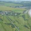
Chanonry Ness, Cross
Cross (Period Unassigned), Witch Association (18th Century)
Site Name Chanonry Ness, Cross
Classification Cross (Period Unassigned), Witch Association (18th Century)
Alternative Name(s) Cross Of The Ness; Coinneach Odhar Stone; Chanonry Point
Canmore ID 14336
Site Number NH75NW 2
NGR NH 7417 5638
Datum OSGB36 - NGR
Permalink http://canmore.org.uk/site/14336
- Council Highland
- Parish Rosemarkie
- Former Region Highland
- Former District Ross And Cromarty
- Former County Ross And Cromarty
NH75NW 2 7417 5638.
(NH 7417 5638) Cross (NR) Tradition says that here the last witch in Scotland was burnt (NAT).
OS 25" map, Ross-shire, (1905)
Cross of Ness (NR)
OS 6" map, (1959)
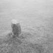
This is the Cross of the Ness (Information from C G MacDowall, Town Clerk, Fortrose), the remains consisting of a circular stone shaft 1ft in diameter, that stood about 5ft high in 1871.
Name Book 1871.
The remains of a circular stone shaft, reduced to a height of 0.5m, situated on Fortrose golf course.
According to Mr Frazer, a retired bank manager (Clifton, Rosemarkie) with a knowledge of local history and place names, it is called 'Coinneach Odhar Stone' after the local prophet Kenneth MacKenzie who, it was reputed, was burnt here. This name is also used in the local tourist guide.
Mr C G MacDowall, although confirming the name 'Cross of the Ness', nevertheless appeared unsure of the facts, and may be an unreliable authority.
Visited by OS (N K B) 1 March 1966.
Cross shaft; tradition that last witch in Scotland burnt here. On the 1st edition of the OS 6-inch map (Ross and Cromarty, sheet xc; 1881).
Later 1st Mill AD?
CFA/MORA Coastal Assessment Survey 1998.


