
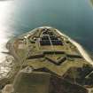
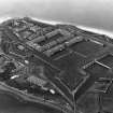
Fort George


Artillery Fortification (18th Century), Barracks (18th Century), Barracks (First World War), Hospital (First World War), Prisoner Of War Camp (First World War)(Possible), War Memorial (20th Century)
Site Name Fort George
Classification Artillery Fortification (18th Century), Barracks (18th Century), Barracks (First World War), Hospital (First World War), Prisoner Of War Camp (First World War)(Possible), War Memorial (20th Century)
Alternative Name(s) Ardersier, Campbelltown Fort; Ardescroon Point; Ardersier Point; Seaforth Highlanders War Memorial Plaque
Canmore ID 14317
Site Number NH75NE 3
NGR NH 76079 56674
Datum OSGB36 - NGR
Permalink http://canmore.org.uk/site/14317


First 100 images shown. See the Collections panel (below) for a link to all digital images.
- Council Highland
- Parish Ardersier
- Former Region Highland
- Former District Inverness
- Former County Inverness-shire
In the First World War Fort George is reported as being the location of a prisoner of war camp after 1916, although it does not appear in a 'List of Places of Internment' in Britain, its colonies and the Dominions, issued in January 1919 by the Prisoners of War Information Bureau.
Information from HS/RCAHMS World War One Audit Project (GJB) 8 October 2013.
During the First World War Fort George was the regimental depot of the Seaforth Highlanders. The Fort remained the depot until the amalgamation of the Seaforths with the Queen's Own Cameron Highlanders in 1916, to form the Queen's Own Highlanders, who continued to occupy the fort.
Information from HS/RCAHMS World War One Audit Project (GJB) 12 September 2013.
NH75NE 3 76079 56674
(NH 7625 5670) Fort George (NR)
OS 6" map, (1959)
Not to be confused with (predeccessor) Fort George (Inverness Castle, NH 6664 4510), for which see NH64NE 9.
For barrow (Ardescroon Point) found in construction, see NH75NE 6.
For associated miltary training area and ranges (centred NH 7800 5700) and nearby coast defence battery, see NH75NE 27.00 and NH75NE 30 respectively.
For K6 telephone call boxes within the area of Fort George, see NH75NE 40.
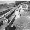
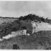
Fort George is a unique example of 18th century military achitecture created by William Skinner betwen the years 1747 and 1769; the first date is the probable date of the first of Skinner's plans; the latter is the completion date of the garrison church.
S Cruden 1960.
The fort and church are in excellent condition and are War Department property, the fort is to be scheduled in the near future.
Visited by OS (R D) 16 August 1964.
NH 759 567 An extended programme of excavation, watching brief and survey was completed on the Point Battery (the western extremity of the fort). In order to waterproof the three vaulted structures buried within the thickness of the main rampart, the earthwork itself was removed over the buildings.
After trial excavations in November 1993 and a watching brief in January 1994, the main programme of work carried on until May 1994 with intermittent archaeological input. This entailed the recording of all elements of those gun platforms, revetting wall, flues, drains, as well as the earthworks themselves (parapet, firing step and main rampart), which had to be removed in advance of the repair work.
Evidence was discovered of the Point 'Pepper Pot', and associated passage which was damaged by a 19th century gun setting along with detailed information of the construction of other parts of the 18th century layout. The primary gun platforms were of slab stone construction over sloping mortar footings. The brick-faced parapet was built directly on to the wide stone wall which forms the outer face of the main rampart. The firing step and main fill of the rampart behind these revetting elements, was of extremely solid construction, comprising a series of rolled gravels and sand deposits to a depth of over 6m. The tops of the vaults themselves were in turn found to be sealed by a combined deposit of clay and pitch soaked gravelly sand forming a waterproof layer of a high quality only breached by later drainage features.
Sponsor: Historic Scotland
G Ewart 1994d.
NH 759 567 A watching brief and excavations were carried out at the NE Battery during the summer of 1995, in the course of repair work to the Battery and casemates. The sequence of construction of the outer and inner rampart walls was derived, along with evidence for the 18th century waterproofing. Contemporary graffiti was recorded on the mortared faces of some of the structures, and the sequence of repairs and alterations was recorded.
Sponsor: Historic Scotland.
G Ewart, D Stewart and A Dunn 1995.
NH 762 567 A watching brief was maintained by Kirkdale Archaeology during repair work on the SE casemates, in March 1996. The casemate roofs were exposed to allow for repair and rewaterproofing. These resembled closely the casemates previously excavated at the NE part of the fort (which were erected earlier in the original building programme), indicating that an identical building plan was being followed. However, the foundations for the firing step wall, founded above the casemate roofs on the gravel infill of the rampart, was of simpler design than its NE equivalent, indicating an evolution in building design during the programme of works.
The general sequence of construction of the rampart and associated structures was confirmed by 1996 observations. A full graphic and photographic record was made.
A watching brief in July 1996 during the installation of a new water main included recording the remains of the demolished wall to the E portal of the Place of Arms. No finds were made.
Sponsor: Historic Scotland
G Ewart, D Stewart and A Dunn 1996
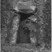
NH 7618 5681 A watching brief was undertaken in December 1997 during trenching work for an electricity cable outside the casemates in the NE corner of the fort. The casemates are stone-built rooms, buried under the rampart of the fort, to provide shelter during an artillery barrage. They were built between 1749-62, with each one being designed to hold 40 men.
The discovery of two soakaways situated relatively close to each other indicated that they were probably constructed at different times, although their close similarity in construction indicated a relationship - quite probably that they were both of military design. A drain running from one casemate may once have been a more common feature.
Sponsor: Historic Scotland
D Murray 1998
NH 762 567 A watching brief was conducted in December 1998. The excavation of a cable trench was monitored at both ends of a track. The first section was in the ordnance yard where, below much modern disturbance, a late 18th or 19th-century stone and brick culvert with construction debris and yard infill relating to the same period was recorded. The other section was in a yard at the rear of the north staff block; nothing of significance was noted.
Sponsor: Historic Scotland.
P Sharman 1999
NH 7625 5670 Assessment excavations were carried out in June 1999 at two locations within Fort George (NMRS NH75NE 3), to test for the survival of original surfaces.
The first area was on the ravelin, which forms the eastern point of the earthwork defences, in the area to the E of the guardhouse which now houses the visitor centre. The purpose here was to ascertain what evidence, if any, exists for the authenticity of the present tarmac paths and any other paths in the area.
The second area was in front of the horse's door into the stables at the rear of the provision store and bakery E of the chapel at the W end of the fort. The stable is shortly to provide accommodation for a horse employed in offering cart rides for visitors. Excavation was required to determine whether or not there was evidence for cobbling or paths associated with the original use of the stables.
It was evident that considerable earth-moving had taken place fairly recently, notably associated with the revetment wall of the principal ditch and the partial rebuilding of the splayed inner entry of the ravelin gate.
Sponsor: Historic Scotland.
J Triscott 1999
NH 7618 5681 During December 1999 a programme of cable trenching was undertaken by local contractors under archaeological supervision. The project consisted of cutting a trench along the E access road from a point to the SE of the fort at the edge of the glacis to a point within the fort near the N entrance to the south sallyport.
Within the confines of the south sallyport the new trench followed the exact line of the old water main with the result that all the layering was backfill from that period. The variable depth of the water pipe at the S entrance to the tunnel might indicate some form of masonry threshold below.
Sponsor: Historic Scotland.
D Stewart 2000
NH 7625 5670 Various objects were recorded and retrieved in June 2001 from behind a collapsed length of tongue-and-groove panelling in a casemated barrack room in the curtain wall N of the parade ground in Fort George.
The rear of the panelling was partly covered in dirt and various finds that had fallen behind it. These were retrieved in 2m sections, measured from the S end of the panelling. Each of the sections was photographed to show the objects in situ, but their location was not recorded in any more detail. Their importance lies in their reflection of the daily life of the servicemen billeted in the room over many decades. The finds include sergeants' swagger sticks with copper-alloy ferrules bearing the regimental crest, blank bullets, a bayonet in a leather sheath, cutlery, cut-throat razors, decayed paper items including a timetable to Edinburgh, highly decorated pipe bowls, and many tins of talcum powder -presumably less reflective of cleanliness than of the need to keep dry feet, preventing foot-rot.
Sponsor: Historic Scotland
P Sharman and G Ewart 2001
The fortifications and barracks are visible on wartime oblique aerial photographs (S463.H53, 75-83, flown 31 August 1941).
Information from RCAHMS (DE), February 2004
NH 762 567 Archaeological monitoring was undertaken in February 2004 during renovation work and several minor assessments. These were in the Georgian and Victorian latrine blocks, the firing step palisade at the E point of the defences, and the rotted wooden remains found above the tide line in the mud at the shore end of the S pier.
The firing step examination is notable for the surviving evidence of the palisade posts. It appears that the posts were put in place before the firing step was built, and that the revetting wall for the step was built around the posts, with the brick setting in the base of the ditch holding the posts in place.
A minor excavation into the shoreline mud suggested that the accumulated deposits at the N end of the pier may hide an almost intact section of original wooden cladding.
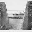
NH 764 569 An archaeological evaluation was undertaken in June 2004 of a rarely seen part of the fort defences located on the N beach between the high and low water marks. The structure is the channel and tunnel of the sluice believed to have been designed to allow the main moat to be flooded for defensive purposes. The structure appears to be mostly intact, undoubtedly the result of the quality of materials used in its build, and appears to be contemporary with the original construction of the fort. The difference in height between the floor of the sluice and the existing floor of the moat (1.4m) suggests that the moat would only have had a shallow layer of water, and that only achieved at very high tides. However, a 1796 plan clearly shows a ditch dug along the central line of the moat and linking up at the sluice at both ends. This may well indicate that a narrow, but deep, water-filled channel within the moat may be all that ever flooded. Without excavating the deposits in the moat it is not possible to ascertain the original level of the channel.
NH 760 566 A watching brief was undertaken in August 2004 during the excavation of two post-hole sockets at the main entrance to the fort. The post-holes were located at either side of the public entrance path to the fort and were intended to form the main gateposts for the re-established defence structures. The locations of the excavated post-holes are apparently the same as the ones cut in the 18th century when the wooden defence network was originally erected. The remains uncovered below the current path surface are of archaeological interest in relation to the defence system of the fort and were left in situ, protected by a hessian cover from the modern concrete used to support the new posts.
Archive to be deposited in the NMRS.
Sponsor: HS.
D Stewart and C Shaw 2004
NH 762 567 A watching brief was undertaken in February 2005 at Fort George (NH75NE 3) while sub-contractors undertook the initial phase of construction work for the installation of BT cables. The work was restricted to three main areas within the fort complex: the Sally Port entrance, the area around the telephone boxes, and an area at the casemates near the Sally Port exit.
Also, a short period of archaeological monitoring was undertaken while sub-contractors undertook work in preparation for the installation of a new guardhouse at the Sally Port entrance to the fort. No features or finds of archaeological significance were discovered during these works.
Archive to be deposited in NMRS.
Sponsor: HS.
C Shaw 2005
The first Fort George was in Inverness. When it was damaged in 1745 a replacement was built on Ardersier Point. They are differentiated by Fort George and Inverness, Fort George.
In the National Library of Scotland is a series of Military Maps and Drawings (many are coloured) of the Board of Ordnance, dealing with the troubled times of the 18th Century, Reference "MSS. 1646-1652".
A number refer to Fort George on Arderseer Point, the peninsula at the opeing of the inner Moray Firth. It has been distinguished from the Fort George at Inverness by the name of the Peninsula, and sometimes is referred to on the Plans as in 'North Britain'.
In Case, or volume, No.1646 are the following:-
Number. Year.
Z.2/39. 1749 "A Plan of Fort George on Arderseer Point, North Britain, 1749". With Reference. Scale 100 Feet in an Inch. There is a copy.
Z.2/40. 1750 "Plan of Fort George, North Britsin, shewing state of Works into 1750 and what is proposed to be done ion 1751" name of W.Skinner. There is a copy.
Z.2.41. - With 42, 43, and 44, shews little if any Architectural interest.
Z2.45. 1752. "Plan of Fort George, North Britain, 1752". With Explanation. Scale 100 Feet to an Inch. There is a copy.
Z.2/46. 1752. "Section through the Gateway, Bridge, and Covered Way". and Elevation. Scale 5Feet to an Inch. Drawn by Chas. Tarrant. marked as "Delivered by W. Skinner, 1752"
Z.2/47. 1752. "Plan Elevation and Section of the Guard House in the Ravelin at Fort George 1752". Drawn by Chas. Tarrant and bears the name of W. Skinner. Scale 5 Feet to an Inch.
Z.2/48. 1753. "Plan of Fort George, North Britain, shewing how far executed 1753". Drawn by Chas. Tarrant and marked as "Delivered by W. Skinner. There is a copy.
Z.2/50. 1753. "Plan and elevations and Sections of the Barracks for 1600 Men and Officers, For George, 1753". Drawn by C. Tarrant. Signed W. Skinner.
" 1754. "Plan Elevations and Sections of the North Pile of Barracks, shewing how high they were raised in the year 1754". Scale 20 Feet to an Inch. Bears name of C. Tarrant.
Z.2/49. 1754. "Plan of Fort Georfe shewing how far the Works were carried on in the year 1754". Scale 100 Feet to an Inch. Drawn by C.Tarrant.
Z.2/51. 1756. Another Plan shewing state of Works in 1756. Scale 100 Feet to an Inch.
In Case, or Volume, No.1647, are the following Drawings:-
Z.2/53.No date. "A Plan of the West Front of Fort George commanding the Channel" with Explanation and with Section through the South Casmate. Scale 25 Feet to an Inch.
Z.2/54. 1762. "Plan of the 'Fountations' of Prince Henry Frederick's Bastion with the preposed Sheds for Capentry, Smiths and Wheel-wrights Shops with room for Shott Pounds for Shott and Shells, 1762". Scale 25 Feet to an Inch. Signed W. Skinner 1762. There is a copy.
Z.2/55. 1762. "Plans Elevations And Sections of the Storehouse for Provisions, and Barrack-masters Stores, 1762". Scale 10 Feet to an inch..Signed W. Skinner 1762. There is a copy.
Z.2/56.No date. "A Plan of the Point of Land at Aderseer with the designed Fort as traced thereon, by William Skinner, Director of Engineers". With Explanation. Scale 100 Feet to an Inch. Signed W. Skinner. There are 2 copies.
Z.2/58.No date. Plan, and detail to scale of 10 Feet to an Inch, of the Pier.
Z.2/59. 1769. "A Plan of Fort George, North Britain, 1769". Scale 100 Feet to an Inch. There is a copy made in 1801 and there are 2 copies made in 1808.
Z.2/60.No date. "Powder Magazine, For George". Plan sna Sections to scale of 10 Feet to an Inch, and smaller scale Elevation.
In Case, or Volume, No. 1649 is this DRawings:-
Z.3/50. 1792. "Plans Elevations and Sections of the North Ordnance Store-House at Fort George, &c". Scale 12 Feet to an Inch. Signed by H. Rudyerd Captn Rl Engineers1792.
There are also in Case, or volume, No.1650, the following two:-
Z.46/57. 1787. "Drawings of the Pier at Fort George" and a Plan shewing outline of the East Emd of Fort George with refernece to the Estimate for Works and Repairs preposed in the year 1787. With Explanation. Scale 100 Feet to an Inch. Signed by Chas. Shipley, Captain, & Engineer.
Z.47/21.No date."A General Plan of Fort GEorge and Vicinity". Shews Arderseer Point and the opposite shore. Coloured. Scale 400 Feet to an Inch.
Photographic Survey (1955)
Photographic survey by the Scottish National Buildings Record in 1955.
Aerial Photography (1969)
Oblique aerial photographs of Fort George, Inverness-shire, taken by John Dewar in 1969.
Note (1979)
Fort George NH 762 567 NH75NE 3
This Hanoverian artillery-fort occupies a coastal promontory. It was built by William Skinner in 1747-69 and is still in military use.
RCAHMS 1979
Cruden 1963, 242-5; Macivor 1970
Excavation (1 November 1993 - 20 May 1994)
NH 759 567 An extended programme of excavation, watching
brief and survey was completed on the Point Battery {the western
extremity of the fort). In order to waterproof the three vaulted
structures buried within the thickness of the main rampart, the earthwork itself was removed over the buildings.
After trial excavations in November 1993 and a watching brief in
January 1994, the main programme of work carried on until May
1994 with intermittent archaeological input. This entailed the
recording of all elements of those gun platforms, reverting wall, flues, drains, as well as the earthworks themselves {parapet, firing step and main rampart), which had to be removed in advance of the
repair work.
Evidence was discovered of the Point 'Pepper Pot' and associated
passage which was damaged by a 19th-century gun setting along
with detailed information of the construction of other parts of the
18th-century layout. The primary gun platforms were of slab stone
construction over sloping mortar footings. The brick-faced parapet
was built directly on to the wide stone wall which forms the outer
face of the main rampart. The firing step and main fill of the rampart
behind these revetting elements, was of extremely solid construction,
comprising a series of rolled gravels and sand deposits to
a depth of over 6m. The tops of the vaults themselves were in turn
found to be sealed by a combined deposit of clay and pitch soaked
gravelly sand forming a waterproof layer of a high quality only
breached by later drainage features.
G Ewart 1994
Sponsor: Historic Scotland
Kirkdale Archaeology
Excavation (15 May 1995 - 11 August 1995)
NH 759 567 A watching brief and excavations were carried out at the NE Battery during the summer of 1995, in the course of repair work to the Battery and casemates. The sequence of construction of the outer and inner rampart walls was derived, along with evidence for the 18th century waterproofing. Contemporary graffiti was recorded on the mortared faces of some of the structures, and the sequence of repairs and alterations was recorded.
G Ewart, D Stewart and A Dunn 1995
Sponsor: Historic Scotland
Kirkdale Archaeology
Watching Brief (5 July 1996 - 23 July 1996)
A watching brief in July 1996 during the installation of a new water main included recording the remains of the demolished wall to the E portal of the Place of Arms. No finds were made.
G Ewart, D Stewart, and A Dunn 1996
Sponsor: Historic Scotland
Kirkdale Archaeology
Excavation (25 March 1996 - 16 June 1996)
NH 762 567 A watching brief was maintained by Kirkdale Archaeology during repair work on the SE casemates, in March 1996. The casemate roofs were exposed to allow for repair and rewaterproofing. These resembled closely the casemates previously excavated at the NE part of the fort (which were erected earlier in the original building programme), indicating that an identical building plan was being followed. However, the foundations for the firing step wall, founded above the casemate roofs on the gravel infill of the rampart, was of simpler design than its NE equivalent, indicating an evolution in building design during the programme of works.
The general sequence of construction of the rampart and associated structures was confirmed by 1996 observations. A full graphic and photographic record was made.
G Ewart, D Stewart, and A Dunn 1996
Sponsor: Historic Scotland
Kirkdale Archaeology
Watching Brief (19 August 1997 - 1 September 1997)
A watching brief was carried out over two days during minor excavation works within the fort. A N-S trench extending 67m from the NE casemate to the main E-W axis road, before turning W to run for a further 160m, was opened to a depth of 600mm, being 360mm in width. Later, a sequence of 7 pits were excavated to insert manholes along the length of this longer trench. In all trenches, the sequence established was of the modern surface overlying mixed sands and gravels, in turn overlying the clean yellow sand which underlies all of the Fort structures. The latter is known, from previous excavations, to cover earlier, substantial stone drains at a depth of c.1m below the parade ground surface, a depth not achieved in the recent excavations.
Sponsor: Historic Scotland
G Ewart and D Stewart 1997
Kirkdale Archaeology
Watching Brief (2 December 1997 - 9 December 1997)
Kirkdale Archaeology were asked to maintain a watching brief at Fort George during work to dig a trench for an electricity cable outside the casemates in the NE corner of the fort. This work involved removal of the concrete pathway outside the casemates, and the excavation of the trench by machine, while the digging inside the casemates, and at the E end of the pathway (where it runs underneath an access ramp to the wallhead) was done by hand. The casemates are stone built rooms, buried under the rampart of the fort, to provide shelter during an artillery barrage. They were built between 1749 and 1762, with each one being designed to hold 40 men. They are built of roughly faced red and yellow sandstone, with finer work around the doors and windows.
Dateable finds were not recovered from any contexts, except the sand directly below the present concrete surface, which is presumably relatively recent. While many hand made bricks, or fragments thereof, were noted, these are of little use in dating any of the structures located, as the squad informed me that there still are numerous of these bricks lying around, and they get built into work that they do today. The presence of two soakaways situated relatively close to each other hints that they were probably constructed at different times, although their close similarity in construction indicates a relationship, quite probably that they are both of military design. The drain that ran out of one casemate may once have been a more common feature, as this casemate has a dirt floor, unlike the others which were dug into, which had concrete floors, which will have involved the removal of deposits within the casemates, before laying the floor. This may well have been an original feature, although due to the generally disturbed nature of the site this could not be accurately determined. Some confidence can be attached to the interpretation of the cut noted apparently running under the casemates, even though this feature was not bottomed. The fact that it ran tight against the side of the casemates makes it very unlikely that this feature could post date their construction, so any function other than being a construction cut seems improbable. This feature therefore can reasonably be dated to the construction of the casemates, between 1749 and 1762. This in turn makes it seem highly probable that the sand it was cut through is indeed the natural beach material, although this
deposit may have been partially quarried away. Indeed the black, organic look to the fill of the construction trench, if simply redeposited material, would indicate that there was originally a topsoil covering the sand here.
Sponsor: Historic Scotland
D Murray 1998
Kirkdale Archaeology
Watching Brief (10 February 1997 - 11 February 1997)
NH 7618 5681 A watching brief was carried out by Kirkdale Archaeology over two days during minor excavation works within the fort. No significant features or deposits were found.
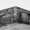
Work on the blacksmith's shop necessitated a further watching brief. The W part of the shop is partly divided by a short N-S wall protruding from the N wall, which serves to create an alcove in the NW corner, and the wall contains a chimney flue on its E side; these features indicate the position of the furnace.
A likely sequence of events can be suggested: the building was erected c 1760 on levelled sand deposits; the floor was then flagged throughout; after the smithy fell out of use, the flags were removed, where they could be reused, and the building became a coal store, the floor of which was eventually concreted over.
Sponsor: Historic Scotland
G Ewart and D Stewart 1997
Watching Brief (24 February 1997 - 11 March 1997)
Kirkdale Archaeology carried out a watching brief during the excavation of cable trenches along the N and S roadways within the fort. The S works entailed machine excavation of a trench 350m in length (Trench 1) extending from the Fort Substation within Casemate 12 to the Pump-House just E of the Point Battery Casemates. This route ran close to the inner revetting wall of the South Rampart, running along the frontages of the casemates and the Powder Magazine compound wall.
The excavation of Trench 1 commenced at its central point near the Officers latrines, work running in both directions from this point. The cable was intended to link with the Fort Substation located in one of the Casemates near the Guardhouse, and hence the trench terminated at the doorway of Casemate no. 12. From here, the trench ran for 95m along the outer face of the Powder Magazine wall before curving to the N around the NE corner of a ramp joining the Courtyard to the S Rampart Terreplein. This part of the trench revealed the foundations of the Powder Magazine enclosure wall, at a depth of 25-28cm below the present ground level.
No finds were recovered from the entire length of Trench 1.
Trench 2 comprised a second cable trench along the front of the NE Casemates, again 80cm in depth and 60cm wide, running for c80m. The material removed from this trench proved to be highly disturbed levelling material of the courtyard, and yielded no finds.
Kirkdale Archaeology 1997
Watching Brief (1 December 1998 - 9 December 1998)
A watching brief was conducted at Fort George near Inverness, Highland Region (NGR NH 762 567). The excavation of a cable trench was monitored at both ends of the track. The first section was in the Ordnance Yard where, below much modern disturbance, a late 18th- or 19th-century stone and brick culvert with construction debris and yard infill relating to the same period was recorded. The other section was in a yard at the rear of the North Staff Block. Nothing of significance was noted.
Sponsor: Historic Scotland
P Sharman 1998
Kirkdale Archaeology
Watching Brief (4 December 1999 - 5 December 1999)
During December 1999 a programme of cable trenching was undertaken by local contractors under archaeological supervision. The project consisted of cutting a trench along the E access road from a point to the SE of the fort at the edge of the glacis to a point within the fort near the N entrance to the south sallyport.
The present metalled road leading up to the South Sallyport through the Glacis cutting is a relatively recent addition to the structure of the Fort and in itself has little historical value. Only at the points where it cuts original masonry will there be any archaeological interest. The depth of this excavation was clearly too shallow to expose buried structures.
Within the confines of the south sallyport the new trench followed the exact line of the old water main with the result that all the layering was backfill from that period. The variable depth of the water pipe at the S entrance to the tunnel might indicate some form of masonry threshold below.
Sponsor: Historic Scotland.
D Stewart 1999
Kirkdale
Excavation (7 June 1999 - 10 June 1999)
Assessment excavations were carried out in June 1999 at two locations within Fort George, to test for the survival of original surfaces.
The first area was on the ravelin, which forms the eastern point of the earthwork defences, in the area to the E of the guardhouse which now houses the visitor centre. The purpose here was to ascertain what evidence, if any, exists for the authenticity of the present tarmac paths and any other paths in the area.
The second area was in front of the horse's door into the stables at the rear of the provision store and bakery E of the chapel at the W end of the fort. The stable is shortly to provide accommodation for a horse employed in offering cart rides for visitors. Excavation was required to determine whether or not there was evidence for cobbling or paths associated with the original use of the stables.
It was evident that considerable earth-moving had taken place fairly recently, notably associated with the revetment wall of the principal ditch and the partial rebuilding of the splayed inner entry of the ravelin gate.
Sponsor: Historic Scotland.
J Triscott 1999
Kirkdale Archaeology
Artefact Recovery (21 June 2001 - 22 June 2001)
(NH 7625 5670) Various objects were recorded and retrieved in June 2001 from behind a collapsed length of tongue-and-groove panelling in a casemated barrack room in the curtain wall N of the parade ground in Fort George.
The rear of the panelling was partly covered in dirt and various finds that had fallen behind it. These were retrieved in 2m sections, measured from the S end of the panelling. Each of the sections was photographed to show the objects in situ, but their location was not recorded in any more detail. Their importance lies in their reflection of the daily life of the servicemen billeted in the room over many decades. The finds include sergeants' swagger sticks with copper-alloy ferrules bearing the regimental crest, blank bullets, a bayonet in a leather sheath, cutlery, cut-throat razors, decayed paper items including a timetable to Edinburgh, highly decorated pipe bowls, and many tins of talcum powder -presumably less reflective of cleanliness than of the need to keep dry feet, preventing foot-rot.
Sponsor: Historic Scotland
P Sharman and G Ewart 2001
Kirkdale Archaeology
Watching Brief (9 August 2004)
NH 760 566 A watching brief was undertaken in August 2004during the excavation of two post-hole sockets at the main entrance to the fort. The post-holes were located at either side of the public entrance path to the fort and were intended to form the main gateposts for the re-established defence structures. The locations of the excavated post-holes are apparently the same as the ones cut in the 18th century when the wooden defence network was originally erected. The remains uncovered below the current path surface are of archaeological interest in relation to the defence system of the fort and were left in situ, protected by a hessian cover from the modern concrete used to support the new posts.
C Shaw and D Stewart 2004
Sponsor: Historic Scotland
Kirkdale Archaeology
Excavation (18 February 2004 - 20 February 2004)
NH 762 567 Archaeological monitoring was undertaken in February 2004 during renovation work and several minor assessments. These were in the Georgian and Victorian latrine blocks, the firing step palisade at the E point of the defences, and the rotted wooden remains found above the tide line in the mud at the shore end of the S pier.The firing step examination is notable for the surviving evidence of the palisade posts. It appears that the posts were put in place before the firing step was built, and that the revetting wall for the step was built around the posts, with the brick setting in the base of the ditch holding the posts in place.A minor excavation into the shoreline mud suggested that the accumulated deposits at the N end of the pier may hide an almost intact section of original wooden cladding.
C Shaw and D Stewart 2004
Sponsor: Historic Scotland
Kirkdale Archaeology
Excavation (21 June 2004 - 23 June 2004)
NH 764 569 An archaeological evaluation was undertaken in June 2004 of a rarely seen part of the fort defences located on the N beach between the high and low water marks. The structure is the channel and tunnel of the sluice believed to have been designed to allow the main moat to be flooded for defensive purposes. The structure appears to be mostly intact, undoubtedly the result of the quality of materials used in its build, and appears to be contemporary with the original construction of the fort. The difference in height between the floor of the sluice and the existing floor of the moat (1.4m) suggests that the moat would only have had a shallow layer of water, and that only achieved at very high tides. However, a 1796 plan clearly shows a ditch dug along the central line of the moat and linking up at the sluice at both ends.This may well indicate that a narrow, but deep, water-filled channel within the moat may be all that ever flooded. Without excavating the deposits in the moat it is not possible to ascertain the original level of the channel.
C Shaw and D Stewart 2004
Sponsor: Historic Scotland
Kirkdale Archaeology
Excavation (14 February 2005 - 23 February 2005)
NH 762 567 A watching brief was undertaken in February 2005 at Fort George (NH75NE 3) while sub-contractors undertook the initial phase of construction work for the installation of BT cables. The work was restricted to three main areas within the fort complex: the Sally Port entrance, the area around the telephone boxes, and an area at the casemates near the Sally Port exit.
Also, a short period of archaeological monitoring was undertaken while sub-contractors undertook work in preparation for the installation of a new guardhouse at the Sally Port entrance to the fort. No features or finds of archaeological significance were discovered during these works.
C Shaw 2005
Sponsor: Historic Scotland
Kirkdale Archaeology
Excavation (4 December 2007 - 10 December 2007)
Minor excavations were carried out in advance of construction work at Fort George, Ardersier.
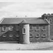
Immediately inside the Principal gate there is a large parade ground at the W limit of which stand the Artillery block and Staff blocks to the S and N respectively. The two “U” shaped barrack blocks are in the middle of the Fort and enclose the Barrack Square. The W part of the Fort houses stores and, at the far W end, the Chapel.
Trench 1 of the current excavation was to the rear (W) of the NW corner of the artillery block within a walled courtyard, measuring 13.50m N‐S by 8.40m wide, where a cabin is to be erected. The trench was excavated to a depth great enough to allow the excavation of an area under the N wall to feed service ducts through.
N of the courtyard the trench was to continue to the N (Trench 2) to a service box and continue a short way N (Trench 3) finally turning E (Trench 4) to an existing servicebox.
Prior to and during the return visit on the 10th of December Trenches 2 and 3 were excavated but only the tarmac had been removed from the Eastern 6.15m of the long E‐W stretch at the S end of the excavation (Trench 4).
There were finds recovered both by the contractors and the archaeologist, these were photographed and listed but only the pottery sherds were retained.
Information from OASIS Id: kirkdale1-60209 (A Radley) 2007
Field Visit (4 May 2010)
NH 7626 5684 and NH 7638 5688 (centred on) A record was made on 4 May 2010 of an area of coast to the N of Fort George. This area had been subject to severe wave erosion leading to the exposure of a series of contexts of suspected archaeological significance. Most of the contexts were found to be natural in origin, with deposits of windblown sand and beach pebbles predominating. However, amongst the natural deposits were contexts with definite anthropogenic origins. The area’s close proximity to two middens and Fort George suggests that the possibility of further remains of archaeological significance existing in this area is high.
P Fox and D Murray 2010
Sponsor: Historic Scotland
Kirkdale Archaeology
OASIS Id: kirkdale1-279368
Standing Building Recording (5 May 2010 - 7 May 2010)
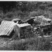
NH 7620 5652 and NH 7655 5700 A record was made on 5–6 May 2010 of two sets of WW2 landing platforms. The platforms lay to the SW of Prince Henry’s Bastion (NH 7620 5652) and to the NE of Prince Edward’s Ravelin (NH 7655 5700). The NE Platforms were being eroded at a significant rate and a measured plan was made to record their current condition. A full photographic and written record was made at both locations.
P Fox and D Murray 2010
Sponsor: Historic Scotland
Kirkdale Archaeology
Excavation (20 March 2012)
NH 7647 5680 A small excavation was carried out on 20 March 2012 near the entrance to Fort George prior to the installation of a scale model to aid visitor orientation. Four sondages were dug to look for evidence of surfaces or hard standing relating to the ramp leading to the ramparts to the NE of the trench. This large grassed over slope seemed likely to have been used to carry artillery up to the ramparts summit, and it seemed possible that this would have required such a feature. No evidence was found for any such ground preparation.
Archive: RCAHMS (intended)
Funder: Historic Scotland
David Murray, Kirkdale Archaeology 2012
OASIS Id: kirkdale1-310859
Project (March 2013 - September 2013)
A project to characterise the quantity and quality of the Scottish resource of known surviving remains of the First World War. Carried out in partnership between Historic Scotland and RCAHMS.
Watching Brief (17 February 2014)
A watching brief was undertaken on the 17th February 2014 for a cable supply pillar to the southeast of the visitor centre at Fort George (NMRS NH75NE 3) as part of Scheduled Monument Consent. Work revealed disturbed deposits in the trench from previous cable-laying and installation. However, deposits surviving in the southeast facing section of the trench provided evidence for the build-up of material on the southwest side of the former Guard House.
The lower courses of the wall foundations were uncovered in the southeast-facing section of the trench revealing dressed sandstome blocks with well-pinned and mortared joints. One of the sandstone blocks had been removed in the past to provide access for services into the interior of the building.
Small finds recovered from the trench included animal bone fragments, 'industrial period' ceramics and glass, slate fragments, two pieces of lead, and ceramic drain fragments.
Funder: Turner Estate Solutions Ltd
Struart Farrell
Watching Brief (28 August 2015)
Under the terms of its PIC contract with Historic Scotland, Kirkdale Archaeology was asked to carry out the archaeological recording at Fort George (Fig. 1) of a trench excavated in order to facilitate the repair of a water pipe located in the southern portion of the fosse, between the covered way surrounding the ravelin (to the east) and the south-east bastion of the fort (to the west). Although nothing of particular archaeological interest was revealed during the works, the fort and its surroundings must be considered to be of high archaeological potential, and any future ground-breaking work should be similarly accompanied by an archaeological watching brief.
G Ewart 2015
Sponsor: Historic Scotland
Kirkdale Archaeology

