
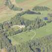
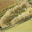
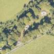
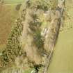
Balnuaran Of Clava, North-east


Chambered Cairn (Bronze Age), Cup And Ring Marked Stone (Prehistoric), Stone Circle (Bronze Age)
Site Name Balnuaran Of Clava, North-east
Classification Chambered Cairn (Bronze Age), Cup And Ring Marked Stone (Prehistoric), Stone Circle (Bronze Age)
Alternative Name(s) Clava Cairns
Canmore ID 14257
Site Number NH74SE 1
NGR NH 75765 44478
Datum OSGB36 - NGR
Permalink http://canmore.org.uk/site/14257


First 100 images shown. See the Collections panel (below) for a link to all digital images.
- Council Highland
- Parish Croy And Dalcross (Inverness)
- Former Region Highland
- Former District Inverness
- Former County Inverness-shire
NH74SE 1 7576 4447.
(Centred NH 75714443) Stone Circles & Cairns (OE) (Urns containing calcined bones found)
OS 6"map, Inverness-shire, 2nd ed., (1906)
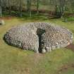
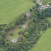
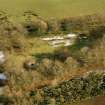
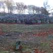
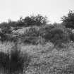
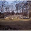
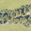
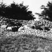
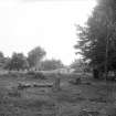
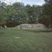
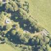
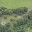
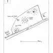
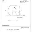
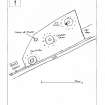
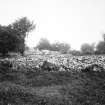
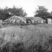
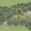
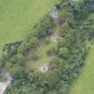
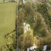
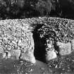
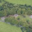
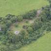
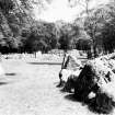
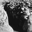
Clava passage-grave (Balnuaran of Clava, North-east) The cairn lies only 123 feet to the north-east of the central cairn, in the middle of the Clava cemetery. The kerb is of massive boulders and has a diameter of 55 feet. The stones graduate irregularly in size from 3 feet by the entrance on the south-west side to 1 foot 6 inches at the back, though the pair of stones which actually form the entrance are lower, 2 feet high. The cairn material is now piled up inside the kerb and reaches a height of nearly 10 feet. There is a distinct platform of stoney material, rather irregular in outline, extending for 10 to 18 feet beyond the kerb and having a depth of about 1 foot 6 inches.
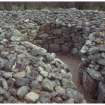
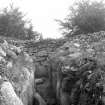
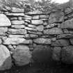
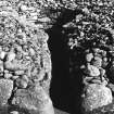
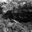
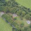
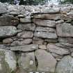
The passage is constructed of large boulders. The chamber has a diameter of 12-13 feet. The lowest course is also of upright boulders, those by the entrance 3 feet 9 inches and 3 feet high, those at the back 2 feet 5 inches high. The wall at the back still remains up to 7 feet high consisting of eight rough and irregular courses including some very large stones. There is only a slight oversailing of the upper part giving a maximum overhang of 1 foot.
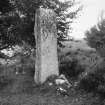
The cairn is surrounded by a circle of eleven standing stones (and one small earthfast stone on the north-north-east). The stones are irregularly spaced and vary from 24 to 37 feet from the kerb having an overall diameter of 110 to 117 feet. This irregularity is probably partly due to the fact that some of the stones (those on either side of the entrance, and the next stone to the north and north-east stone (W Jolly 1882) were reset in the 19th century. The two stones on either side of the entrance one 9 feet and 5 feet 3 ins. high.
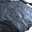
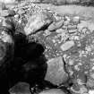
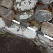
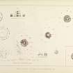
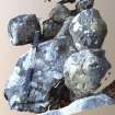
Cupmarks occur on the innermost stone of the passage on the north-west side (W Jolly 1882) and also on a stone on the north side of the kerb (S Piggott 1956). The former stone has certainly four and possibly seven simple cups; the latter, which measures 2 feet 8 inches by 1 foot 5 inches, is covered with cupmarks, one cup and ring meandering lines.
A S Henshall, Visited 15 April 1957; W Jolly 1882; J Fraser 1884; C Innes 1862; S Piggott 1956.
NH 7576 4447 The remains of this cairn are as described above.
Revised at 1/2500.
Visited by OS (W D J) 25 April 1962.
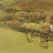
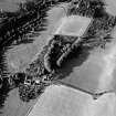
Air photographs of the Balnuaran of Clava cairns taken by Jill Harden in 1989, are in Inverness Museum (8901.21-22 and 8907.02 INVMG). Information from J Harden 1989.
Field Visit (July 1979)
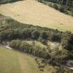
Balnuaran of Clava, North-east (INV 9) NH 757 444 NH74SE 1
A Clava passage-grave within a circle of eleven standing stones (and a small earthfast. stone on the N). The cairn, measuring 16.8m over a kerb of graded boulders, is surrounded by a platform of stones extending outwards for up to 5.5m. The chamber measures 4m in diameter and is entered from the SSW. Cup-marks occur on the innermost stone of the NW side of the passage, and one of the kerb-stones on the N bears about fifty cup-marks (one of them surrounded by a single ring) together with several pecked channels.
RCAHMS 1979, visited July 1979
(Piggott 1956, 192; Henshall 1963-72, i, 361-6; Ritchie and Maclaren 1972, 8)
Excavation (1995)
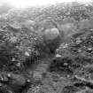
NH 7576 4447 The second season of excavation (see Bradley 1994) focused on the NE passage grave and investigated the chronological relationship between the five main elements on the site: the internal structure of the cairn, its kerb, its entrance passage, the platform upon which the site appears to be built and the stone circle which surrounds the entire monument. All proved to have been constructed during a single phase. The cairn contained a core of massive blocks and redeposited turf or topsoil which formed a stable structure supporting the corbelled burial chamber. This was covered by a skin of smaller rubble which was revetted by the kerbstones. These were only shallowly bedded in the ground and had been held in position by a rubble ramp piled up against the exterior of the monument. The composition of this ramp or platform matched the constructional sequence in the cairn itself, with quarried slabs similar to those employed in the chamber towards the base of this deposit and rounded boulders towards its surface. This feature continued unbroken across the entrance to the tomb and extended outwards as far as the stone circle. One of the monoliths belonging to this circle lacked any socket and was bedded in the tail of the ramp- thus it could not have been erected after that material was in position. The entrance passage had been cleared of any archaeological deposits during an unrecorded excavation. A few flecks of cremated bone were found on the surface of the platform. Over a hundred lithic artefacts were recovered during the excavation and samples were taken for study by soil micromorphology, pollen analysis and radiocarbon dating.
A section was also cut through the rubble ramp of the SW passage grave (NH 7568 4447) (NH74SE 4) at the point where the kerbstones were at their lowest. In this case the kerb lacked any sockets and again the ramp must have been a primary feature of the monument. It was constructed in exactly the same manner as the platform of the NE cairn, but in this case it had been surfaced with flat slabs.
Sponsors: British Academy, Historic Scotland, Reading University, the Society of Antiquaries of London and the Society of Antiquaries of Scotland, with additional assistance from Highland Regional Council and National Trust for Scotland.
R Bradley 1995.
Publication Account (1995)
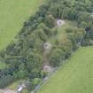
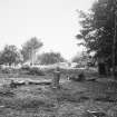
Three impressive round cairns, each surrounded by a ring of standing stones, are now fenced off within a wooded enclosure. They have given their name to a whole group of similar burial cairns found only in Inverness and Nairn Districts and in the Black Isle. The three cairns at Clava are set in a line, the central cairn being a ring cairn while the other two, known as the NE and SW cairns, are passage graves. All have been dug out at different times without proper record. The ring cairn at Clava was dug by modern methods in 1953, but owing to previous distu rbances little was found except some scraps of cremated human bone. As seen today, the cairns are open in the centre, but they would not have been like this originally. The chamber walls of the passage-graves would have been corbel led inwards until the gap could be covered with one large capstone, the passages roofed with flat slabs and then the whole structure covered with more stones, so the cairns would have been 3.10m high or more, while the ring cairn, which has no passage, and has a larger central space, is thought to have been filled, after burial, with earth and stones up to the top of the surrounding walls.
All the cairns have a graduated kerb with larger boulders near the entrance on the southwest side. The passages and chambers are lined with slabs, graduated in the chambers, and carrying upper courses of drystone walling. Round the cairns are set circles of standing stones, varying in number, but having taller or more impressive stones on the south or southwestern side. The modern road curs between the SW cairn and part of its circle of stones.
Unique features of the three cairns at Clava are the low stone platforms surrounding the cairns, and the cobbled 'causeways' linking the platform round the ring cairn to three of the standing stones. Excavation in 1994 showed the causeways to be contemporary with the ring cairn and its stone circle. Several stones in the cairns have cup-marks made before the stones were set in place; the clearest are those in the NE cairn (nearest to the car park) which has cup-mark s on the innermost lefth and slab in the passage, while a fin e cupmarked boulder with a ring round one cup is set in the kerb on the north of the same cairn.
Just west of the central cairn, against the fence, is a smallring of stones 3.7m in diameter. This may be the surviving kerb of a late type of bronze-age cairn known as a kerb cairn, where a low cairn generally covered a cremation burial within the kerb.
Information from ‘Exploring Scotland’s Heritage: The Highlands’, (1995).
Contour Survey (1996)
NH 75 44 Earthwork survey identified the remains of a circular mound 13m in diameter situated roughly midway between the NE cairn at Balnuaran of Clava and Mains of Clava North. At least half the mound had been destroyed by ploughing but its lowest levels survived beneath a field wall built during the 19th century. There were a number of unusually large stones in the wall at this point, suggesting that this may have marked the position of another megalithic tomb.
Sponsors: Historic Scotland, Reading University, with assistance from Highland Archaeology Service.
R Bradley 1996
Watching Brief (22 February 2018)
A watching brief was carried out by CFA Archaeology Ltd within the Scheduled Monument of Clava Cairns, Highland. A tree bole from a fallen tree was cleaned by hand and inspected prior to removal of the tree by a tree surgeon. No features, deposits or artefacts of archaeological significance were identified.
Information from CFA Archaeology Ltd.
Field Visit (November 2019)
NH 75734 44402 (centred) Visitor numbers to Balnuaran of Clava Cairns have increased year-on-year but especially within the last five years. This has created its own problems with damage and erosion being caused to the archaeological sites within the Property in Care boundary.
An erosion survey was carried out, in November 2019, within the environs of Balnuaran of Clava Cairns to look at the general condition and state of erosion suffered to the archaeological sites. The survey revealed that the monuments are suffering from various degrees of erosion ranging from intrusive to, in many cases, severe. The main cause for the erosion is visitor footfall, not only to the monuments themselves but to the roots of the surrounding tree cover.
The survey also noted the eastern half of a rectangular stone-built feature beginning to erode out of the grass between Cairn 3 and 2. The feature also appears on a recent LIDAR survey of Balnuaran of Clava Cairns as either two joined squares or a rectangular feature with a dividing wall.
Archive: NRHE (intended)
Funder: Historic Environment Scotland
Graeme Carruthers − CFA Archaeology Ltd
(Source: DES Vol 21)
Note
Date fieldwork started: 08/11/2018
Compiled by: ScRAP
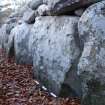
Balnuarin of Clava NE Kerbs
Scotland's Rock Art Project ID: 3042
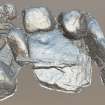
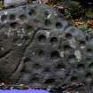
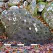
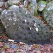
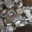
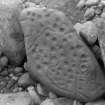
Panel notes: The panel is part of the complex of monuments at Clava ('Clava cairns'), well known and much frequented by visitors, with a car park and interpretation. It is located on a level river terrace to the SE of the river Nairn, in the flat bottom of the SW to NE valley. The panel itself is a kerbstone on the N edge of the NE Cairn at Balnuarin of Clava, and stands out because although similar in size to the other kerbstones it is a darker redder colour and has many deep and distinct cups. There is a hollow immediately in front of it where visitors have scraped away the earth. This panel is referenced in Canmore 14257 (Balnuaran-of-clava-north-east).
Panel notes: The panel is a rounded but flat-faced sandstone boulder 1.1m by 0.6m. 42 cups are visible, fairly evenly spaced and of varying depths, covering the whole surface. In addition, near one end is 1 cup with a partial ring. Clear curving grooves partition the panel into 3 main sections. The grooves all appear to start at the edge of the panel and move inwards, terminating without crossing the panel completely. Two grooves terminate in cups, and one cup is crossed. One of the grooves leads into the cup within the partial ring. The grooves and cups are sharp, clear and unworn and show distinct toolmarks. There is a groove around the edge of much of the panel, following the natural bedding planes in the rock. The panel is one of the ring of outer kerbstones of the NE cairn, at the N edge. No cup marks have been found on any other of the outer kerbstones of this cairn. Part of the panel is below the current ground surface. Canmore 14257 includes a photo from 1931 of the whole panel when recently excavated. Note that Canmore 14279 (SW Cairn) wrongly also includes the same photo.
Note
Date fieldwork started: 04/07/2019
Compiled by: NOSAS
Balnuarin of Clava NE Centre 2
Scotland's Rock Art Project ID: 3200
Location notes: This panel is part of the complex of monuments at Clava ('Clava cairns'), well known and much frequented by visitors. There is a car park and interpretation. It is located on a level river terrace to the SE of the river Nairn, in the flat bottom of the SW to NE valley. The panel is situated in the NE cairn at Clava, at the top of the inner chamber wall on the NW side. The Good Stones: A New Investigation of the Clava Cairns, Richard Bradley, Society of Antiquaries of Scotland Monograph Series Number 17, Edinburgh 2000 shows its location in illus 37 p37.
Panel notes: The panel is a flat slab of sandstone, 0.27m wide x 0.05m thick, and extending back into the wall about 0.036m. There is a single well-formed cup, with a possible ring around it. At the top of the wall, it is a loose stone and may not be in its original position.
Note
Date fieldwork started: 11/06/2019
Compiled by: NOSAS
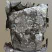
Balnuarin of Clava NE Passage 2
Scotland's Rock Art Project ID: 3201
Location notes: This panel is part of the complex of monuments at Clava ('Clava cairns'), well known and much frequented by visitors. There is a car park and interpretation. It is located on a level river terrace to the SE of the river Nairn, in the flat bottom of the SW to NE valley. The panel is located halfway along the passage into the NE cairn on the NW side.
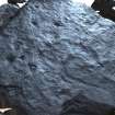
Panel notes: This panel is one of the orthostats in the passage of the NE cairn at Clava, sandstone, and about 0.9m high x 0.8m broad. Photogrammetry reveals several very worn possible cups on the panel. It is recorded (The Good Stones: A New Investigation of the Clava Cairns, Richard Bradley, Society of Antiquaries of Scotland Monograph Series Number 17, Edinburgh 2000) on p33: "Cup-marked stones were identified on two orthostats on the north side of the entrance passage. One of these panels also included a cup-and-ring mark". This one is shown as having 'two or more cups' (illus 33 p34), the other panel mentioned is ScRAP 3099. No sketch is provided in the publication.
Note
Date fieldwork started: 11/08/2018
Compiled by: NOSAS
Balnuarin of Clava NE Passage 1
Scotland's Rock Art Project ID: 3099
Location notes: The panel is part of the complex of monuments at Clava ('Clava cairns'), well known and much frequented by visitors. There is both a car park and on site interpretation. The site is located on a level river terrace to the SE of the river Nairn, in the flat bottom of the SW to NE valley. The panel itself is the last large stone on the left when entering the passage into the NE Cairn at Balnuarin of Clava. This panel has previously been recorded as a part of the Balnuaran of Clava, North East, chambered cairn and stone circle monument (Canmore ID: 14257).
Panel notes: The panel is a flat slab of sandstone, set upright and about 1.2m long by 0.9m high. It forms part of the row of large stones which define the passage into the centre of the cairn, and is the last stone on the left before entering the central chamber. There are 4 cupmark motifs on the top half of the panel. An L-shaped pecked groove in the bottom half of the panel is especially clear in the photogrammetric model. Starting from about 0.1m above ground level, it is vertical for about 0.2m, and then turns sharp right and goes horizontally for about 0.7m, curving and aiming lower towards the edge of panel.
Note
Date fieldwork started: 11/06/2019
Compiled by: NOSAS
Balnuarin of Clava NE Centre 1
Scotland's Rock Art project ID: 3199
Location notes: This panel is part of the complex of monuments at Clava ('Clava cairns'), well known and much frequented by visitors. There is a car park and interpretation. It is located on a level river terrace to the SE of the river Nairn, in the flat bottom of the SW to NE valley. It is located high up in the N wall of the chamber of the NE cairn.
Panel notes: This panel is one of the stones which make up the wall of the chamber of the NE cairn. It is a slab of sandstone, visibly 0.6m x 0.15m thick, and of unknown depth into the wall. On its flat upper surface is one distinct cup and one other possible cup. The stones above this panel are loose and may not be in their original positions. One stone partly obscures the cup. The Good Stones: A New Investigation of the Clava Cairns, Richard Bradley, Society of Antiquaries of Scotland Monograph Series Number 17, Edinburgh 2000 illus 37 p37 shows a cup mark high up in this wall, but not in this location. This panel was discovered whilst searching for the reported cup which was not located.

